Waikato Plains facts for kids
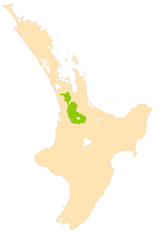
The Waikato Plains are a big, flat area of land in the northwest of New Zealand's North Island. They were formed by the mighty Waikato River, which is the longest river in the country. Over many, many years, the river changed its path several times. Long ago, it flowed towards the east, but now it flows northwest into the Tasman Sea near Port Waikato.
The plains can be split into two main parts. The first is the Waikato Basin, which surrounds the city of Hamilton. The second is the Lower Waikato Plain, which is closer to where the river meets the sea. These two parts are separated by some low hills like the Hakarimata Range and the Taupiri Range, found between Ngāruawāhia and Huntly.
Life on the Waikato Plains
The Waikato Plains are quite busy for New Zealand. Over 250,000 people live here in an area of about 8,000 square kilometers. More than half of these people live in the city of Hamilton.
Farming the Land
A long time ago, much of this land was swampy. Early settlers, like the Morrin brothers, worked hard to drain the water. Now, the plains are used for lots of farming.
Farmers here raise dairy cattle for milk and sheep. They also grow crops like grain and maize. Dairy farming is the most important part of the local economy.
The lower part of the plains is known for its vineyards, where grapes are grown. In the middle part, especially around Cambridge and Matamata, you'll find some of the best stables for thoroughbred horses in the Southern Hemisphere.
Unique Landscapes
A lot of the land on the plains is peaty. This means the soil is made from old, partly decayed plants. Some big areas, especially in the northeast, are still undrained swamps. You can also find dozens of shallow lakes here, like Lake Waikare, which are connected to the river system.
 | Kyle Baker |
 | Joseph Yoakum |
 | Laura Wheeler Waring |
 | Henry Ossawa Tanner |


