
Hakarimata Range facts for kids
Quick facts for kids Hakarimata Range |
|
|---|---|

Hakarimata summit tower
|
|
| Highest point | |
| Elevation | 374 m (1,227 ft) |
| Geography | |

Hakarimata Range
Location in New Zealand
|
|

The Hakarimata Range is a group of hills in the Waikato region of New Zealand. It sits on the western side of the Ngāruawāhia town. These hills look over where the Waikato River and Waipa River meet. The Hakarimata Range is separated from the Taupiri Range by a narrow passage called the Taupiri Gorge, where the Waikato River flows.
After the invasion of the Waikato in 1864, some parts of the Hakarimata area were taken by the government. Today, about 1,850 hectares (around 4,570 acres) of native forest in the range are protected. This area is a special scenic reserve. A local group, the Hakarimata Restoration Trust, started in 2001. They work to help take care of the range and its natural beauty.
Contents
Where is Hakarimata?
Today, people usually think of Hakarimata as the hills right next to Ngāruawāhia. However, older maps show that the 'Hakarimata Range' used to stretch further south. It went all the way to what is now State Highway 23. Long ago, the road from Whatawhata to Raglan was even described as crossing over the Hakarimatas.
What does the Name Hakarimata Mean?
The name Hakarimata comes from a big feast that happened in the 1600s. The Ngāti Maniapoto people joined the local Waikato people to celebrate a baby's birth. There was a huge amount of uncooked food from the forest. So, the name Hākari-kai-mata means "uncooked food mountain." Over time, this name became shorter, turning into Hakarimata.
What is Hakarimata Made Of?
Hakarimata is part of a larger geological feature called the Kawhia Syncline. This is a big fold in the Earth's layers. The rocks here are mostly sandstones, siltstones, and greywacke. These rocks are very old, from the Late Triassic period. They have been folded and broken by Earth's movements. Over time, other sedimentary rocks have also covered them.
Amazing Plants and Animals

Hakarimata has the largest remaining area of a special type of forest. This is a broadleaf-podocarp lowland forest. This kind of forest used to cover much of the Waikato region. Hakarimata is also special because it's where different types of forests meet. It's near the southern edge of kauri forests and the northern edge of beech forests. This means you can find plants and animals from all three forest types here.
Plants of Hakarimata
You can see very tall rata and rimu trees reaching above the other trees. Below them, the main trees are tawa, kohekohe, hinau, rewarewa, mangeao, and pukatea. There are also miro, Hall's totara, and tanekaha. The reserve is home to several rare plants too. One of these is Alseuosmia quercifolia, also known as topara. It has a very strong, pleasant smell in spring.
Animals of Hakarimata
Many different animals live in the Hakarimata bush. You might spot tui birds, kereru (New Zealand pigeons), fantails, and pipwharauroa. There are also karearea (falcons), pekapeka (bats), copper skinks, and Auckland green geckos. Even tiny peripatus (velvet worms) can be found.
The streams in Hakarimata are home to 16 types of native fish. These include short-finned and long-finned eels. You can also find banded, short-jaw, and giant kōkopu. In the mid-1990s, people worked to help native fish. They built fences along 12 kilometers (about 7.5 miles) of streams. They also added bridges and planted over 10,000 trees and shrubs. This helped connect the forest canopy with the Waikato River. By 2003, the number of fish in the streams had increased. A new fish species, the lamprey, was also discovered.
Protecting Hakarimata from Pests
Since the Hakarimata land became a protected reserve, the forest has slowly grown back. This is despite challenges like past logging and fires. Many pests have also affected the area. These include pigs, goats, possums, cats, hedgehogs, rats, mice, stoats, weasels, and ferrets. Sometimes, deer and wallabies also appear.
Groups work to control goats, possums, and rats. In 2011, they even tried out new self-resetting traps for possums. There's also a risk of kauri dieback disease, which harms kauri trees. To stop this disease from spreading, a boot cleaning station was set up at the Huntly end of the range in 2015. This helps visitors clean their shoes before entering the forest.
Fires are another danger. In 2017, a large area of forest on a ridge was burned.
The Hakarimata Quarry
There is a large quarry at 181 Waingaro Road, near Ngāruawāhia. A quarry is a place where rocks and minerals are dug out of the ground. This quarry opened in 1948. It now digs well below sea level. In 2008, a plan to make the quarry twice as big was not allowed. This expansion would have destroyed native trees that were estimated to be 800 years old. The quarry provides about 35% of the area's rock needs. Efforts have been made to protect the environment around the quarry. For example, bait stations were put in place to control pests. In 2018, the quarry was recognized for helping native fish move more easily through streams by extending fish passages.
Exploring the Hakarimata Tracks

People have been enjoying walks in the Hakarimata Range since at least 1892. There are two main walking paths that offer amazing views of the Waikato Plains below.
The main path is the Hakarimata Walkway. It is 12 kilometers (about 7.5 miles) long and takes about 7 hours and 30 minutes to walk. This path follows the ridge from Parker Road in the north to the Hakarimata Rail Trail in the south.
The long-distance walking trail called Te Araroa follows the Hakarimata Walkway to the summit. At the top, there's a viewing tower. From here, on a clear day, you can see the coast, the Waikato Basin, and even Mount Ruapehu. Te Araroa then goes down from the summit using the Hakarimata Summit Track. This track is 2 kilometers (about 1.2 miles) long and takes about 3 hours to go up and down. It has 1,349 steps and leads to Brownlee Avenue in Ngāruawāhia. In 2016, about 140,000 people visited these steps, a huge increase from 5,000 in 2011.
There are also several shorter walks that use parts of these main tracks:
- Kauri Loop Track: This track is at the northern end, starting from the Parker Road car park. It's 3 kilometers (about 1.9 miles) long and takes about 2 hours for the full loop. You can reach a special kauri grove in about 40 minutes. Here, you'll find one of the largest kauri trees in Waikato. It's 7 meters (about 23 feet) around and 36.7 meters (about 120 feet) tall, and is thought to be over a thousand years old. From the Southern Lookout, you can see Huntly, the northern Waikato lakes, Hamilton, and even Tongariro on a clear day.
- Waterworks Walk: This walk is in the middle of the range, starting from Brownlee Avenue. It's 1 kilometer (about 0.6 miles) long and takes about 1 hour to go up and back. It follows the Mangarata Stream to a reservoir built in 1922, which used to be Ngāruawāhia's water supply. In November 2016, a beautiful Tomokanga (archway) was added near the start of this walk.
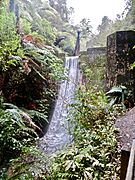
- Hakarimata Rail Trail: This trail is at the southern end. It's 1.5 kilometers (about 0.9 miles) long and takes about 30 minutes. It follows the path of the old Glen Massey railway. A short extra path from here leads to the beautiful Cascades.
Gallery
-
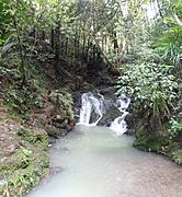
Cascades at the foot of the ascent to the summit from the south
-
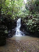
Mangarata Stream waterfall, just above the reservoir
-
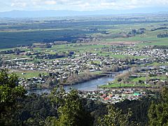
Ngāruawāhia, Waikato basin and Kaimais from Hakarimata Summit
-
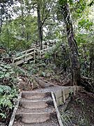
Some of the 1349 steps on the Summit Track
-
Mangarata Dam spillway. Parataniwha is common in the valleys.
-
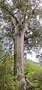
The platform is to protect the big tree from kauri dieback
-
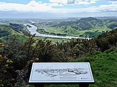
Huntly and Waikato River from Northern Lookout


