Whatawhata facts for kids
Quick facts for kids
Whatawhata
|
|
|---|---|
|
Township
|
|

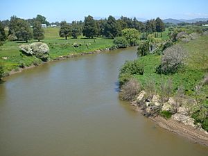
from SH23 bridge
|
|
| Country | New Zealand |
| Region | Waikato |
| District | Waikato District |
| Ward | Newcastle Ward |
| Electorates |
|
| Area | |
| • Territorial | 0.93 km2 (0.36 sq mi) |
| Elevation | 20 m (70 ft) |
| Population
(June 2023)
|
|
| • Territorial | 330 |
| • Density | 355/km2 (919/sq mi) |
| Time zone | UTC+12 (NZST) |
| • Summer (DST) | UTC+13 (NZDT) |
Whatawhata is a small town in the Waikato region of New Zealand. It sits on the east side of the Waipā River. You can find it where two main roads, State Highway 23 and State Highway 39, meet. It's about 12 kilometers (7.5 miles) from the city of Hamilton. The famous Te Araroa walking trail also goes through Whatawhata.
Contents
Discover Whatawhata: History and Culture
Early History: Māori Life and Flour Mills
Long ago, Whatawhata was a village for the Ngāti Māhanga people. You can still find two important Māori meeting places, called marae, on the west side of the river: Te Papa-o-Rotu and Ōmaero.
In the 1800s, many places in the Waikato region had flour mills. Whatawhata got its own mill in 1855. It started making flour by the end of that year. The area was good for growing wheat. Another mill was built nearby at Karakariki by 1860.
European Settlement and Changes Over Time
British soldiers arrived in Whatawhata on December 28, 1863, during the Invasion of the Waikato. They came by land and by river. Soldiers found many peach trees and enjoyed the fruit. A year later, a telegraph line was built, connecting Whatawhata to other places.
In 1915, Whatawhata was described as a farming and dairying town. It had a hotel, a school, and a post and telegraph office. Small steamboats used to travel up and down the Waipā River from Huntly, reaching as far as Pirongia. Back then, Whatawhata was a big Māori center with over a thousand people.
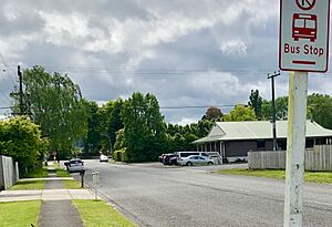
Today, things have changed. The old post office is now a petrol station and a small shop. Coaches have been replaced by buses, which run four times a day. The river is much quieter now, with few boats. In 1949, the AgResearch hill-country research station opened in Whatawhata, focusing on farming research.
A coal mine also operated in Whatawhata. Campbell Coal Ltd started it in 1920. By 1923, it was fully open and produced coal until the 1970s.
In 1880, Whatawhata had two stores, a bakery, and a hotel. A school, built in 1877, had about 40 children attending. There was also a racecourse around the town. A new post office was built in 1915 after the old one burned down in 1913. Electricity arrived in Whatawhata in 1922.
Marae: Important Cultural Meeting Places
Whatawhata is home to two marae, which are special meeting grounds for Māori people. These marae are connected to the Waikato Tainui tribes, specifically the hapū (sub-tribes) of Ngāti Māhanga and Ngāti Hourua.
- Ōmaero Marae: This marae has a meeting house called Te Awaitaia.
- Te Papa o Rotu Marae: Also known as Te Oneparepare Marae, it has a meeting house called Papa o Rotu.
These marae are important places for gatherings, ceremonies, and keeping Māori culture alive.
Whatawhata's Community: Demographics
Whatawhata is a rural settlement. In 2018, it had a population of 303 people. This was an increase of 33 people since 2013. There were 93 households in the settlement.
- About 26.7% of the people were under 15 years old.
- Most people (77.2%) identified as European/Pākehā.
- A significant number (37.6%) identified as Māori.
- Most people (64.4%) said they had no religion. About 22.8% were Christian.
The wider Whatawhata area is larger and includes more people. In 2018, this wider area had a population of 3,267. This was a big increase of 639 people since 2013.
Education in Whatawhata
Whatawhata School is a public primary school for students from Year 1 to Year 8. It teaches both boys and girls. The school opened in 1887. As of March 2024, it has 275 students.
Whatawhata's Weather: Climate
Whatawhata has a mild climate. Here's a quick look at the average temperatures and rainfall:
| Climate data for Whatawhata (1991–2020 normals, extremes 1952–present) | |||||||||||||
|---|---|---|---|---|---|---|---|---|---|---|---|---|---|
| Month | Jan | Feb | Mar | Apr | May | Jun | Jul | Aug | Sep | Oct | Nov | Dec | Year |
| Record high °C (°F) | 32.2 (90.0) |
33.0 (91.4) |
31.3 (88.3) |
26.7 (80.1) |
23.3 (73.9) |
20.6 (69.1) |
20.4 (68.7) |
21.7 (71.1) |
22.9 (73.2) |
24.3 (75.7) |
27.1 (80.8) |
30.2 (86.4) |
33.0 (91.4) |
| Mean maximum °C (°F) | 28.7 (83.7) |
28.4 (83.1) |
27.4 (81.3) |
24.3 (75.7) |
21.0 (69.8) |
17.7 (63.9) |
16.8 (62.2) |
17.6 (63.7) |
19.9 (67.8) |
21.5 (70.7) |
24.4 (75.9) |
26.3 (79.3) |
29.5 (85.1) |
| Mean daily maximum °C (°F) | 23.6 (74.5) |
24.5 (76.1) |
23.1 (73.6) |
20.0 (68.0) |
16.8 (62.2) |
14.3 (57.7) |
13.5 (56.3) |
14.3 (57.7) |
15.8 (60.4) |
17.2 (63.0) |
19.1 (66.4) |
21.4 (70.5) |
18.6 (65.5) |
| Daily mean °C (°F) | 18.4 (65.1) |
19.1 (66.4) |
17.6 (63.7) |
15.1 (59.2) |
12.6 (54.7) |
10.4 (50.7) |
9.5 (49.1) |
10.4 (50.7) |
11.7 (53.1) |
13.1 (55.6) |
14.6 (58.3) |
16.9 (62.4) |
14.1 (57.4) |
| Mean daily minimum °C (°F) | 13.3 (55.9) |
13.7 (56.7) |
12.2 (54.0) |
10.3 (50.5) |
8.4 (47.1) |
6.5 (43.7) |
5.4 (41.7) |
6.4 (43.5) |
7.6 (45.7) |
9.1 (48.4) |
10.1 (50.2) |
12.3 (54.1) |
9.6 (49.3) |
| Mean minimum °C (°F) | 8.5 (47.3) |
8.4 (47.1) |
7.0 (44.6) |
4.1 (39.4) |
1.9 (35.4) |
0.5 (32.9) |
−0.5 (31.1) |
0.6 (33.1) |
2.0 (35.6) |
3.1 (37.6) |
4.1 (39.4) |
6.7 (44.1) |
−0.7 (30.7) |
| Record low °C (°F) | 2.7 (36.9) |
3.0 (37.4) |
0.4 (32.7) |
−2.4 (27.7) |
−3.7 (25.3) |
−3.9 (25.0) |
−3.6 (25.5) |
−3.3 (26.1) |
−2.1 (28.2) |
−0.3 (31.5) |
0.5 (32.9) |
2.6 (36.7) |
−3.9 (25.0) |
| Average rainfall mm (inches) | 89.4 (3.52) |
75.2 (2.96) |
104.9 (4.13) |
116.0 (4.57) |
159.0 (6.26) |
188.2 (7.41) |
192.1 (7.56) |
164.0 (6.46) |
160.7 (6.33) |
138.5 (5.45) |
130.6 (5.14) |
124.1 (4.89) |
1,642.7 (64.68) |
| Source: NIWA | |||||||||||||
 | John T. Biggers |
 | Thomas Blackshear |
 | Mark Bradford |
 | Beverly Buchanan |


