
Waipa River facts for kids
Quick facts for kids Waipa River |
|
|---|---|

From Waingaro Rd bridge looking north down Waipa River to Ngāruawāhia Point bandstand, the Waikato (coming from right) and the Hakarimata Range in the background (19-9-2012)
|
|

The Waipa River – The Waikato's largest tributary
|
|
| Country | New Zealand |
| Physical characteristics | |
| Main source | Rangitoto Range 703 m (2,306 ft) |
| River mouth | Waikato River 20 m (66 ft) |
| Length | 115 km (71 mi) |
| Basin features | |
| Basin size | 3,050 km2 (1,180 sq mi) |
| Tributaries |
|
The Waipa River is a major river in the Waikato region of New Zealand's North Island. It starts in the Rangitoto Range near Te Kuiti. The river flows north for about 115 kilometers (71 miles). It passes through towns like Otorohanga and Pirongia. Finally, it joins the Waikato River at Ngāruawāhia. The Waipa River is the biggest river that flows into the Waikato River. Its main branch is the Puniu River.
In its upper parts, especially near Otorohanga, the Waipa River can be very clear when the water flow is low. This part of the river goes through farms and areas of native bush. It's a good spot for fly fishing for trout. However, you might need permission from landowners to access the river there.
The lower parts of the Waipa River can flood easily. During heavy rains, the water flow can become more than 100 times stronger than during dry times. The river level can rise by as much as 11 meters (36 feet).
In 2013, the Maniapoto Māori Trust Board and local councils made an agreement to manage the river together. This happened after a special law, the Nga Wai o Maniapoto (Waipa River) Act 2012, was passed.
Contents
How Fast Does the Waipa River Flow?

The speed of the Waipa River changes a lot depending on how much water is flowing. When the water is low, it takes much longer for water to travel down the river. When there's a lot of water, it flows much faster.
Here's how long water takes to travel about 130 kilometers (81 miles) from Te Kuiti to where it meets the Waikato River:
| Place | Distance (km) | Time (hours) - Low Flow | Time (hours) - High Flow |
|---|---|---|---|
| Te Kuiti | 0 | 0 | 0 |
| Otorohanga | 37 | 20 | 13 |
| Pirongia | 73 | 40 | 25 |
| Whatawhata | 101 | 59 | 36 |
| Ngāruawāhia | 130 | 98 | 49 |
Power Stations on the Waipa River
People have planned to build power stations near the Waipa River to create electricity.
In 2003, a company called Hydro Power Ltd got permission to build a hydro-electric power station. This type of station uses the force of moving water to make electricity. Work started in 2006, but the company was fined for damaging native plants. The project stopped for a while. Later, another company bought the project and thinks it could still produce a good amount of power.
In 2017, Nova Energy got permission to build a large gas-turbine power station. This station would use natural gas to generate electricity. It's designed to be used for short periods, a few times a day, to help meet electricity needs.
Water Quality and Pollution
Waikato Regional Council regularly checks the water quality in the Waipa River. They measure things like nitrogen, silt, phosphorus, and E. coli.
Overall, the water quality in most parts of the river is not very good. There's too much nitrogen, silt, and phosphorus. These can harm the river's plants and animals. While levels of E. coli (a type of bacteria) have improved because of better sewage treatment, they are often still too high for safe swimming. For a river to be safe for swimming, E. coli levels should be much lower.
North of Otorohanga, the water can be very cloudy (high turbidity). This makes it hard for plants in the river to get enough sunlight. Phosphorus levels also get too high in this area.
Between 1993 and 2012, nitrogen levels increased at all five testing sites. This is mainly because of more intense farming practices in the area. Farming adds a lot of nitrogen to the river each year. Sewage plants and a dairy factory also add some, but much less.
Pollution from nitrogen and phosphorus has generally been getting worse over time. However, the cloudiness of the water (turbidity) has improved in some areas.
Protecting the River and Soil
The Regional Council knows that a lot of land around the Waipa River is at risk of serious soil erosion. This means soil can wash away easily, especially during heavy rains. When soil washes into the river, it adds to the silt pollution.
To help with this, a plan called Project Watershed aims to plant trees and build fences along the riverbanks. This helps to hold the soil in place and stop it from washing into the river.
Organic Farming for a Cleaner River
In 2018, a new idea was launched to help clean up the Waipa River. The plan is to help some dairy farms in the area switch to organic farming. Organic farms use more natural methods and fewer chemicals. This can greatly reduce the amount of pollution that goes into the river from these farms.
Bridges Over the Waipa River
Many bridges cross the Waipa River, connecting communities and allowing people to travel. Here are some of the important ones, listed from north to south:
- The Ngāruawāhia bridge first opened in 1898. It famously collapsed in 1916 when a herd of cattle was crossing it! It was rebuilt in 1922. A newer bridge was opened in 1974.

- The Whatawhata bridge was first built in 1881 out of wood. It was replaced with a stronger bridge in 1924. The current concrete bridge, part of SH23, was built around 1971.

- The Te Rore bridge was built in 1881 and later replaced in 1957. During a big flood in 1958, only the handrails of the new bridge could be seen!

- The Alexandra Bridge at Pirongia was first built by the army around 1865. A new bridge, Pukehoua Bridge, was built upstream in 1912–13 to replace the older one, which was damaged by floods.
- Another Alexandra Bridge, on McClure St in Pirongia, was built in 1882. It was important for reaching a new settlement and connecting to the King Country. Today, SH39 crosses the river on a bridge built in 1953.
Other bridges include the Te Kawa Road bridge (1915), bridges for SH31/SH39 and SH3 in Otorohanga (both 1964), the North Island Main Trunk railway bridge (1887), and the Toa Bridge (1928).
Steamer Services on the Waipa River
For many years, the Waipa River was an important waterway for travel and trade. Traditional Māori canoes (waka) could travel over 50 kilometers (31 miles) up the river. Later, steamboats also used the river.
Pirongia (also known as Alexandra) was a busy place because it was as far as most steamboats could go up the river. This was important until the railway was built in 1880. Some people even tried to use boats as far as Te Kuiti.
Steamboats like the SS Opuatia carried goods and people between Ngāruawāhia, Whatawhata, and Pirongia in the early 1900s. However, traveling upriver could be slow, especially when the water was low.
Over time, as railways and roads improved, river travel became less common. By the 1920s, reports said that large boats could no longer travel far up the Waipa River, mainly due to shallow areas.
Images for kids
-
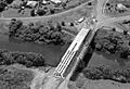
1974 Waipā bridge at Ngāruawāhia under construction in 1972.
-
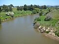
Looking south from the Whatawhata bridge.
-
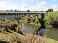
Te Rore bridge from the south.
