Ōtorohanga facts for kids
Quick facts for kids
Ōtorohanga
|
|
|---|---|
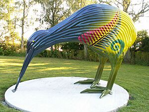
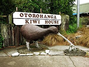
Corrugated Iron Kiwi in Ōtorohanga
|
|
| Country | New Zealand |
| Region | Waikato region |
| District | Ōtorohanga District |
| Ward | Ōtorohanga Ward |
| Community | Ōtorohanga Community |
| Electorates |
|
| Area | |
| • Total | 5.07 km2 (1.96 sq mi) |
| Population
(June 2023)
|
|
| • Total | 3,320 |
| • Density | 654.8/km2 (1,696/sq mi) |
| Time zone | UTC+12 (NZST) |
| • Summer (DST) | UTC+13 (NZDT) |
| Postcode |
3900
|
| Area code(s) | 07 |
Ōtorohanga is a town in the Waikato region of New Zealand's North Island. It's located south of Hamilton and north of Te Kūiti. The town sits on the Waipā River and helps support the local dairy farms. Ōtorohanga is known as the "gateway" to the famous Waitomo Caves. It's also called the "Kiwiana Town" of New Zealand because it used to have a yearly 'Kiwiana Festival'.
Contents
History of Ōtorohanga
Early Times
Before the 1860s, Ōtorohanga was a village for the Ngāti Maniapoto people. It had houses, peach trees, and a flour mill. A very old tree, Huipūtea, which is 300 years old, was the site of a small battle in 1822. This fight was between Ngāti Maniapoto and Ngāpuhi tribes.
After a big conflict called the invasion of the Waikato, the village was left empty. However, a farmer named Lewis Hettit stayed. Even then, the area wasn't completely safe. In 1869, a group led by Te Kooti robbed Hettit's store. But later that year, a meeting with Donald McLean helped bring peace.
In 1885, John William Ellis opened a store and became the postmaster. In 1886, the Ngāti Maniapoto people built a courtroom for the Māori Land Court. This helped settle disagreements and allowed the area to grow. On March 9, 1887, the railway line reached Ōtorohanga. A large hotel was built, mainly for people attending the court. A sawmill also started in 1890, but it closed in 1912.
Recent History
In the early 1900s, many businesses were started by Māori people, especially by John Ormsby (Hōne Ōmipi). The local newspaper, the Otorohanga Times, began in 1912. It later joined with another paper to become the Waitomo News in 1980. A company called McDonald’s started a limestone quarry south of Ōtorohanga in 1968. This quarry was later bought by Graymont in 2015.
Ōtorohanga's population grew quite a lot, from 367 people in 1916 to 1,569 in 1951. After that, the growth slowed down. Even though the population dropped a bit from 2,652 in 1991 to 2,514 in 2013, this fall was much smaller than in other parts of the King Country region.
Harrodsville Story
In 1986, Ōtorohanga made headlines by briefly changing its name to "Harrodsville." This was a way to support a restaurant owner named Henry Harrod. He was being told to change his restaurant's name because of legal threats from Mohamed Al-Fayed. Al-Fayed owned the famous Harrod's department store in London.
To show their support, and to protest against such actions, the people of Ōtorohanga decided to change every business name to "Harrods." The local council even supported this idea. So, Ōtorohanga became "Harrodsville" for a short time.
After this story was reported in British newspapers, Al-Fayed dropped his legal action. Then, Harrodsville and its shops went back to their original names. This event gained a lot of attention around the world. News outlets like the BBC World Service and newspapers in many countries covered the unique protest.
Floods in Ōtorohanga
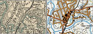
Ōtorohanga is built on the flat land next to the Waipā River. To protect the town from floods, strong walls called stop banks were built between 1961 and 1966. This happened after a very big flood in 1958.
However, floods can still happen. In 2004, Ōtorohanga Primary School was flooded with about 0.6 meters of water. The students had to move to another school temporarily. The whole town was flooded in 1907. Houses were also flooded in 1893 and 1926.
What the People are Like
Ōtorohanga covers about 5.07 square kilometers. In 2018, it had an estimated population of 3,027 people. The population has grown by 15.3% since 2013.
The people living in Ōtorohanga come from different backgrounds. About 67.6% are European/Pākehā, and 40.6% are Māori. There are also smaller groups of Pacific peoples and Asian people.
Marae in Ōtorohanga
A marae is a special meeting place for Māori people. It's a place for gatherings, ceremonies, and important discussions. There are six marae located in and around Ōtorohanga:
- Kahotea Marae and its meeting house, Whatihua, is a place for several Ngāti Maniapoto and Waikato Tainui groups.
- Rereamanu Marae and its meeting house, Te Kawau Kaki Maro, is for the Maniapoto groups of Huiao and Te Kanawa.
- Tārewānga Marae and its meeting house, Te Rau a te Moa, is for the Maniapoto groups of Pare te Kawa, Rungaterangi, Urunumia, and Tārewānga.
- Te Keeti Marae and its meeting house, Parewaeono, is for the Maniapoto groups of Ngutu, Parewaeono, and Urunumia.
- Te Kotahitanga Marae and its meeting house, Te Kotahitanga, is for the Maniapoto groups of Pourahi and Urunumia.
- Turitea Marae and its meeting house, Turitea, is for the Maniapoto group of Pourahui.
Fun Things to Do
Ōtorohanga is famous around the world for its Kiwi House. This was the very first place where people could see kiwi birds up close. In 2008, about 5,000 visitors came to the Kiwi House each month!
The town also has a public library, a swimming pool, a supermarket, and a McDonald's restaurant that's open 24 hours.
Getting Around
Ōtorohanga is on the North Island Main Trunk railway line. The Otorohanga railway station opened in 1887. The Northern Explorer passenger train, which travels between Auckland and Wellington, stops in Ōtorohanga.
Schools in Ōtorohanga
Ōtorohanga has several schools for different age groups:
- Ōtorohanga School is a primary school for students in Years 1 to 8.
- Ōtorohanga South School is also a primary school for Years 1 to 8.
- St Mary's Catholic School is a Catholic primary school for students in Years 1 to 8.
- Ōtorohanga College is a secondary school for students in Years 9 to 13. It also offers community education.
 | Bayard Rustin |
 | Jeannette Carter |
 | Jeremiah A. Brown |


