
Waingaro River (Waikato) facts for kids
Quick facts for kids Waingaro River |
|
|---|---|

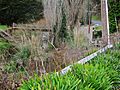
Waingaro Landing and mangroves at mouth of Waingaro River
|
|
| Country | New Zealand |
| Physical characteristics | |
| Main source | 150 m (490 ft) |
| River mouth | Raglan Harbour 0 m (0 ft) |
| Length | 18 km (11 mi) |
| Basin features | |
| Basin size | 123 km2 (47 sq mi) |
The Waingaro River is a river located in the Waikato region of New Zealand's North Island. It starts near Glen Afton and Glen Massey, which are west of Ngāruawāhia. From there, it flows towards the southwest.
The river eventually reaches a northern part of Raglan Harbour. A "tributary" is a smaller stream or river that flows into a larger one. The main tributary of the Waingaro River is Kahuhuru Stream. Many smaller streams also flow into the Waingaro River. At a place called Waingaro, the river gets water from a hot spring.
What is the Waingaro River like?
The lower part of the Waingaro River flows over a type of rock called Puti siltstone. This rock is blue-grey and is very old, about 150 million years old.
How Clean is the Waingaro River?
The Waingaro River is one of the biggest sources of "sediment" in Whaingaroa Harbour. Sediment is like tiny bits of dirt, sand, or rock that get carried by the water. This happens partly because almost all of the riverbanks (99 percent) do not have fences. Fences can help keep soil from washing into the river.
The river's water quality has been changing. "Nutrient pollution" means there are too many nutrients, like phosphorus and nitrogen, in the water. These can come from farms or other sources. The amount of phosphorus in the river has been getting worse. However, the amount of nitrogen has improved.
Scientists use special ways to measure these changes over time. For example, they look at how much pollution changes each year.
Images for kids
-
Waingaro River and hot water pump station. Water from the hot spring is pumped under the road.

