Te Kauwhata facts for kids
Quick facts for kids
Te Kauwhata
|
|
|---|---|
 |
|
| Country | New Zealand |
| Region | Waikato |
| District | Waikato District |
| Ward | Whangamarino Ward |
| Electorates |
|
| Area | |
| • Total | 8.90 km2 (3.44 sq mi) |
| Population | |
| • Total | 2,980 |
| • Density | 334.8/km2 (867.2/sq mi) |
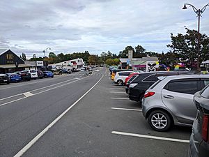
Te Kauwhata is a small town in the north of the Waikato region of New Zealand. It is located near the western shore of Lake Waikare. The town is about 40 km north of Hamilton and 58 km south of Manukau City.
The area around Te Kauwhata is mostly made up of farms. These include dairy farms, farms that raise animals for meat, and places where fruits and vegetables are grown. The town's newest building is its library, which is part of the Waikato District Council. Te Kauwhata was first known as Wairangi. It started to grow around a railway station built in the late 1870s.
Contents
About Te Kauwhata's Name
The name Te Kauwhata can mean a few different things. It might mean "the empty storehouse," which could refer to old Māori food storage buildings. It can also mean "the spiritual medium" or "the frame."
The area where the research farm and railway station are was first called Wairangi. This name was changed to Waerenga in 1897. Waerenga means a clearing in the bush that is used for farming. The name Te Kauwhata began to be used for the town from 1910. The town was officially mapped out in 1912.
Te Kauwhata is surrounded by different types of farms. Locals often call the town "TK." It is also next to the Whangamarino Swamp, which is a large wetland area.
Who Lives in Te Kauwhata?
Te Kauwhata covers about 8.90 square kilometers. As of 2018, its estimated population was around 1,900 people. This means there are about 213 people living in each square kilometer.
| Historical population | ||
|---|---|---|
| Year | Pop. | ±% p.a. |
| 2006 | 906 | — |
| 2013 | 1,134 | +3.26% |
| 2018 | 1,617 | +7.35% |
In 2018, the town had 1,617 people living in 603 homes. This was a big increase of 483 people since 2013. The population has grown a lot over the years.
Most people in Te Kauwhata are of European descent (77.9%). There are also many Māori people (23.0%), along with smaller groups of Pacific peoples (3.3%) and Asian people (7.6%). About 21% of the people living here were born outside of New Zealand.
When asked about their beliefs, about half of the people (52.1%) said they had no religion. Many others (34.0%) were Christian. Some people also followed Māori religious beliefs, Hinduism, Islam, or Buddhism.
Growing Grapes for Wine
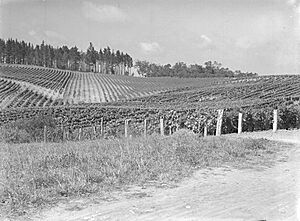
Te Kauwhata is in the middle of one of New Zealand's smaller wine-making areas. This region stretches from Pukekohe, south of Auckland, to Thames and Paeroa. The area is known for its Cabernet Sauvignon, Chardonnay, and Sauvignon blanc wines.
A government research station was started here in 1886. Its goal was to find out what different crops could grow well. In 1901, Romeo Bragato took over the station. The first wine was made there in 1903. The original buildings of the research station are still used today as a place where visitors can taste wine. In 2016, a company called Invivo Wines started using this winery.
Marae: A Special Meeting Place
The local Waikare Marae and Ngāti Hine meeting house is a traditional gathering place. It is used by the Waikato Tainui hapū (sub-tribes) of Ngāti Hine, Ngāti Naho, Ngāti Pou, and Ngāti Taratikitiki. A marae is a very important cultural and spiritual center for Māori people.
Schools in Te Kauwhata
Te Kauwhata has schools for different age groups.
- Te Kauwhata Primary School is for students in Year 1 to Year 6. It is a co-educational school, meaning both boys and girls attend.
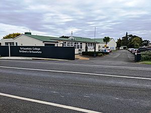
- Te Kauwhata College is a co-educational state secondary school. It is for students from Year 7 to Year 13.
The town also has three places for younger children to learn before they start primary school.
Getting Around Te Kauwhata
The Te Kauwhata railway station was used by trains from 1877 to 1995. These trains ran on the North Island Main Trunk line. A new train service called Te Huia started in August 2020. This service connects Auckland and Hamilton. There are plans to possibly open the Te Kauwhata railway station again in the future.
Te Kauwhata's Weather
| Climate data for Te Kauwhata (1981–2010) | |||||||||||||
|---|---|---|---|---|---|---|---|---|---|---|---|---|---|
| Month | Jan | Feb | Mar | Apr | May | Jun | Jul | Aug | Sep | Oct | Nov | Dec | Year |
| Mean daily maximum °C (°F) | 23.9 (75.0) |
24.4 (75.9) |
22.9 (73.2) |
20.0 (68.0) |
17.2 (63.0) |
14.7 (58.5) |
14.1 (57.4) |
14.9 (58.8) |
16.4 (61.5) |
18.0 (64.4) |
19.9 (67.8) |
22.5 (72.5) |
19.1 (66.3) |
| Daily mean °C (°F) | 18.6 (65.5) |
19.1 (66.4) |
17.5 (63.5) |
14.7 (58.5) |
12.4 (54.3) |
10.1 (50.2) |
9.4 (48.9) |
10.4 (50.7) |
12.0 (53.6) |
13.4 (56.1) |
15.1 (59.2) |
17.3 (63.1) |
14.2 (57.5) |
| Mean daily minimum °C (°F) | 13.4 (56.1) |
13.8 (56.8) |
12.1 (53.8) |
9.5 (49.1) |
7.6 (45.7) |
5.4 (41.7) |
4.6 (40.3) |
5.9 (42.6) |
7.5 (45.5) |
8.8 (47.8) |
10.3 (50.5) |
12.2 (54.0) |
9.3 (48.7) |
| Average rainfall mm (inches) | 82.2 (3.24) |
66.4 (2.61) |
85.4 (3.36) |
86.5 (3.41) |
107.6 (4.24) |
110.3 (4.34) |
106.0 (4.17) |
100.2 (3.94) |
99.5 (3.92) |
87.9 (3.46) |
74.9 (2.95) |
101.9 (4.01) |
1,108.8 (43.65) |
| Mean monthly sunshine hours | 220.7 | 176.6 | 161.7 | 157.5 | 131.6 | 91.0 | 127.8 | 125.2 | 136.8 | 168.0 | 169.3 | 197.4 | 1,863.6 |
| Source: NIWA (rain 1971–2000) | |||||||||||||
 | Anna J. Cooper |
 | Mary McLeod Bethune |
 | Lillie Mae Bradford |


