Manukau City facts for kids
Quick facts for kids
Manukau City
|
||
|---|---|---|
|
Territorial authority of New Zealand
|
||

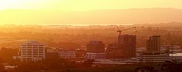
The Manukau skyline looking northwest.
|
||
|
||
| Nickname(s):
South Auckland
|
||
| Motto(s):
Ante Alios Prosili (Be ahead of the times)
|
||

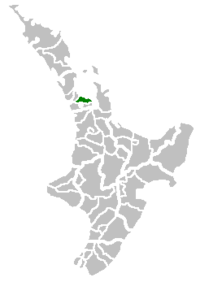
Manukau City within New Zealand
|
||

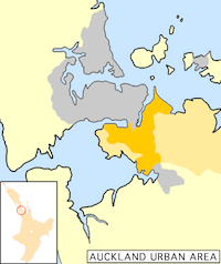
Manukau City (in orange) within the Auckland metropolitan area. The darker orange indicates the urban area.
|
||
| Country | New Zealand | |
| Island | North Island | |
| Region | Auckland | |
| Wards | Botany-Clevedon, Howick, Māngere, Manurewa, Otara, Pakuranga, Papatoetoe | |
| Area | ||
| • Total | 683 km2 (264 sq mi) | |
| Time zone | UTC+12 (NZST) | |
| • Summer (DST) | UTC+13 (NZDT) | |
| Area code(s) | 09 | |
Manukau City was a special area in Auckland, New Zealand. It had its own council that looked after it. Many people called it "South Auckland," but that wasn't its official name. It didn't include places like East Auckland, even though they were inside the city's borders.
Manukau City was quite new. It was formed not long ago, and it grew very quickly. In 2010, it was the third largest city in New Zealand. But in that same year, all the different parts of the Auckland Region joined together under one big council called the Auckland Council.
The name Manukau comes from the Māori language. It means "wading birds." This name comes from the Manukau Harbour, which is west of the city. Some people think the original name of the harbour was Mānuka. This means a marker post that an early chief used to claim the land.
Contents
History of Manukau City
Manukau City was created in 1965. It was formed by joining two areas: Manukau County and Manurewa Borough. The council first had its offices at the Nathan Estate. This place is now the Auckland Botanic Gardens. Later, new, permanent offices were built for them.
Manukau County's Past
Manukau County became smaller on April 1, 1912. The southern part of the county became a new area called Franklin County.
In 1923, Manukau County was about 195 square miles (505 km²). It had a population of 6,146 people. Most of its roads were made of gravel or mud, and some were just tracks.
Geography of Manukau
The Manukau City area is just south of the Ōtāhuhu isthmus. An isthmus is a narrow strip of land connecting two larger land areas. This isthmus is the narrowest link between Auckland City and the rest of the North Island. At its narrowest point, it's only about 1,500 metres wide.
The main part of Manukau is south of this narrow strip of land. It spreads out around State Highway 1 and New Zealand State Highway 20. These are major roads in New Zealand. The area called Manukau Central is near where these two highways meet. It's about 20 kilometres southeast of Auckland city's centre.
Manukau City also included a lot of countryside to the east. This area stretched towards the Hunua Ranges, close to the Firth of Thames. It included small towns like Clevedon and Maraetai.
South of Manukau City are Papakura and the Franklin District. These areas are less urban but are still part of the Auckland Region. Many people see them as part of Auckland's larger urban area.
Auckland Airport is in Māngere, which is in the west of Manukau. It's very close to the Manukau Harbour. Manukau City is also home to the fun theme park Rainbow's End. It also has one of New Zealand's oldest shopping malls, now called Westfield Manukau City.
Transport in Manukau
In 2009, work began on a new train line called the Manukau Branch. This line connects to the main railway line at Puhinui. The Manukau Branch line opened on April 15, 2012. Manukau railway station became the end stop for trains on the Eastern Line.
The Manukau Institute of Technology university campus building is built right over the train station. This makes it easy for students and others to get to the Manukau city centre. On April 7, 2018, a large bus station opened next to the train station. This created a major transport hub for most of the southern Auckland Region.
Population of Manukau
In the late 2000s, almost half of the people living in Manukau City were of European background. About 17% were Māori, 27% were Pacific Islanders, and 15% were Asian. The rest of the population was made up of other groups.
Schools in Manukau
Administrative Divisions
Before Manukau City joined the Auckland Council in November 2010, it was split into seven main areas called wards. Each ward included different suburbs, towns, and communities.
Some of these areas are now part of the Manurewa and Manukau Wards in the new Auckland Council:
- Manurewa Ward includes places like Manurewa, Clendon Park, and Wiri.
- Māngere Ward includes Māngere East, Favona, and Māngere.
- Papatoetoe Ward includes Papatoetoe and Puhinui.
- Otara Ward includes Ōtara, Clover Park, and parts of East Tāmaki.
Other areas are now part of the Howick Ward in the new Auckland Council:
- Pakuranga Ward included Bucklands Beach, Half Moon Bay, and Pakuranga.
- Howick Ward included Mellons Bay, Howick, and Botany Downs.
- Botany-Clevedon Ward was divided into two community boards:
- Botany Community Board included East Tāmaki, Flat Bush, and Botany.
- Clevedon Community Board included Whitford, Beachlands, and Clevedon.
Prominent People from Manukau
Many well-known people have connections to Manukau City:
- Len Brown: He was a former Mayor of Manukau and later became the first Mayor of Auckland.
- Jim Anderton: He was a city councillor in Manukau. He later became the Deputy Prime Minister of New Zealand.
- Sir Barry Curtis: He was the Mayor of Manukau for a long time, from 1983 to 2007.
- David Lange: He was a former Prime Minister of New Zealand. He was also a Member of Parliament for the Māngere area.
- Savage: An award-winning rapper and former member of the music group The Deceptikonz.
Sister City
Manukau City had a special friendship with a city in Japan:
 Utsunomiya, Tochigi, Japan
See also
 In Spanish: Manukau para niños
 | Charles R. Drew |
 | Benjamin Banneker |
 | Jane C. Wright |
 | Roger Arliner Young |


