Ōtāhuhu facts for kids
Quick facts for kids
Ōtāhuhu
|
|
|---|---|
|
Suburb
|
|

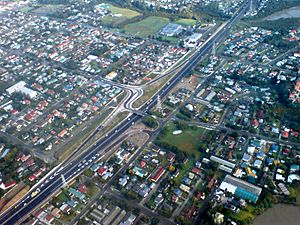
Part of eastern Ōtāhuhu from the air, 2007
|
|
| Country | New Zealand |
| Local authority | Auckland |
| Electoral ward | Manukau ward |
| Local board | Māngere-Ōtāhuhu Local Board |
| Area | |
| • Land | 668 ha (1,651 acre) |
| Population
(June 2023)
|
|
| • Total | 17,710 |
| Train station(s) | Ōtāhuhu railway station |
|
|
||
Ōtāhuhu is a busy suburb in Auckland, New Zealand. It's about 13 kilometers (8 miles) southeast of Auckland's city center. This area is special because it sits on a very narrow strip of land, called an isthmus. This strip connects the North Auckland Peninsula to the rest of the North Island. At its narrowest point, Ōtāhuhu is only about 1.2 kilometers (0.75 miles) wide! It's located between the Manukau Harbour on the west and the Tāmaki River estuary on the east. Ōtāhuhu is considered part of South Auckland.
The name Ōtāhuhu comes from the Māori language. It means "the place of Tāhuhu." Tāhuhu-nui-a-Rangi was an important ancestor of the Ngāi Tāhuhu people.
Contents
People and Population
Ōtāhuhu covers about 6.68 square kilometers (2.58 square miles). As of June 2023, it has an estimated population of 17710 people.
The population has been growing steadily. In 2018, there were 15,165 people living here. This was an increase of about 11.8% since 2013. Many different groups of people live in Ōtāhuhu. In 2018, the population included:
About 46.1% of the people in Ōtāhuhu were born outside of New Zealand. This is higher than the national average of 27.1%.
History of Ōtāhuhu
The area is named after Tāhuhunui-o-te-rangi. He was the captain of the Moekākara waka (canoe). His descendants became the Ngāi Tāhuhu iwi (tribe).
The Ancient Portage
Portage Road is a very old and important path. It runs between the Manukau Harbour and Ōtāhuhu Creek. This path was originally called Te Tō Waka. It was a "portage" where Māori would carry their waka (canoes) between the Manukau and Waitemata harbours. This allowed them to travel easily between the east and west coasts. The famous Tainui waka is traditionally said to have been carried here. In the early 1800s, during the Musket Wars, the Ngāpuhi tribe used this portage. They used it to attack Tainui tribes in the Waikato.
Early European Settlement
Ōtāhuhu was set up in 1847 as a "fencible" settlement. Fencibles were soldiers who were given land. The idea was that they would defend the area if there was a war. However, professional soldiers were used in later conflicts. Many early buildings from this time are now gone. For example, a stone bridge built by the fencibles over the Tāmaki River was removed to make Great South Road wider.
By the 1870s, Ōtāhuhu became the biggest farming town in the Auckland Province. Farmers grew wheat and other crops. They traded these goods with Auckland city using the Tāmaki River.
Railways and First Supermarket
In December 1873, the Southern Line railway opened. It connected Auckland to Penrose. A year and a half later, on May 20, 1875, the line was extended. The Ōtāhuhu railway station was then opened.
Ōtāhuhu is also famous for something else! The very first supermarket in New Zealand opened here on June 18, 1958. It was a Foodtown store, started by Tom Ah Chee and two other shop owners.
Famous People from Ōtāhuhu
Many well-known people went to Otahuhu College. These include:
- David Tua, a famous heavyweight boxing champion.
- David Lange, who later became the Prime Minister of New Zealand.
- Sir Barry Curtis, a former mayor of Manukau City.
Schools in Ōtāhuhu
Ōtāhuhu has several schools for different age groups:
- Otahuhu College is a secondary school for students in years 9–13.
- Otahuhu Intermediate is for students in years 7–8.
- Otahuhu School and Fairburn School are primary schools for years 1–6.
- McAuley High School is a Catholic secondary school for girls in years 9–13.
- St Joseph's School is a Catholic primary school for years 1–8. These two Catholic schools are across the street from each other.
- King's College is a private Anglican secondary school for years 9–13. For years 9–11, it's only for boys. For years 12 and 13, it's for both boys and girls.
- Mt Richmond School is a special school for students with intellectual disabilities.
Most of these schools are for both boys and girls, except for McAuley High School (girls only) and King's College (boys only for some years).
Community Places
The Giac Nhien Temple, a Vietnamese Buddhist temple, is located in Ōtāhuhu. It serves as a spiritual and community hub.
Getting Around: Transport
Ōtāhuhu is a very important place for transport in Auckland. It's a major hub for both roads and railways. A modern bus and train station opened here on October 29, 2016. This station helps people connect easily between buses and trains. It was a big project by Auckland Transport and NZ Transport Agency.
This new station is key to Auckland's public transport system. It helps connect local bus services with frequent train and bus routes. This makes it easier for people to travel across the city.
Ōtāhuhu Today
Today, Ōtāhuhu is known for its many industries. It's part of a large industrial area that includes nearby suburbs like Favona, Māngere East, Mt Wellington, Penrose, and Westfield. This industrial zone stretches along the Māngere Inlet.
The community and town center in Ōtāhuhu are very lively. It acts as a crossroads between Central and South Auckland. Many people from the Pacific Islands live here, adding to its diverse culture.
Sports and Fun
Ōtāhuhu is home to two sports clubs:
- The Otahuhu Rugby Football Club for rugby.
- The Otahuhu Leopards for rugby league.
 | Aaron Henry |
 | T. R. M. Howard |
 | Jesse Jackson |


