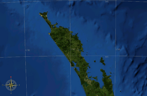
Northland Peninsula facts for kids

The Northland Peninsula is a long piece of land in the far north of New Zealand's North Island. It used to be called the North Auckland Peninsula. This peninsula connects to the rest of the island through a narrow strip of land called the Auckland isthmus. This isthmus is located in the middle of the Auckland city area, between the Waitematā Harbour and the Manukau Harbour.
The Northland Peninsula is not exactly the same as the Northland Region, which is a local government area. The Northland Region covers about 80% of the peninsula's northern part. The southern part of the peninsula is actually part of the Auckland Region.
Contents
Geography and Size
The Northland Peninsula stretches about 330 kilometres (205 miles) towards the northwest from the Auckland isthmus. At its widest point, it is about 85 kilometres (53 miles) across. It has a very twisty coastline with many smaller peninsulas branching off it.
Aupouri Peninsula
The last 100 kilometres (62 miles) of the Northland Peninsula is a smaller peninsula called the Aupouri Peninsula. This part narrows down to only about 10 kilometres (6 miles) wide. At its very northern end, the Aupouri Peninsula has several important capes. These include Cape Maria van Diemen, Cape Reinga, North Cape, and the Surville Cliffs. The Surville Cliffs are the northernmost point of the New Zealand mainland, located at about 34° 23' 47" South.
Harbours and Important Places
The Northland Peninsula is home to some very large and important harbours.
Kaipara Harbour
Partway up the western side of the peninsula, facing the Tasman Sea, is the Kaipara Harbour. This is one of the largest harbours in the world! It stretches about 65 kilometres (40 miles) from north to south.
Hokianga and Bay of Islands
Further north, you'll find the smaller Hokianga harbour. This harbour is very important for its history and culture, especially for the Māori people. Another historically significant place is Waitangi and the nearby Bay of Islands. This area was a major settlement when New Zealand was first being settled by Europeans. It was also where the first signing of the Treaty of Waitangi took place. This treaty is considered the founding document of New Zealand as a nation.
Whangarei City
The largest city on the peninsula (apart from parts of Auckland) is Whangarei. It is located on a harbour that opens into the Pacific Ocean, close to where the peninsula is widest.
See also
 In Spanish: Península de Northland para niños
 | Audre Lorde |
 | John Berry Meachum |
 | Ferdinand Lee Barnett |

