Auckland City facts for kids
Quick facts for kids
Auckland City
|
|||
|---|---|---|---|
|
Former territorial authority of New Zealand
|
|||
|
|||
| Motto(s):
Advance
|
|||

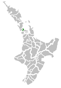
Auckland City's location in the North Island
|
|||

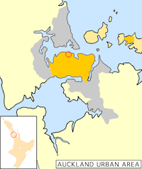
Auckland City's urban areas (in orange) within the greater Auckland urban region (grey). The city centre is ringed. Auckland City also encompassed islands of the inner (upper right) and outer Hauraki Gulf.
|
|||
| Country | New Zealand | ||
| Region | Auckland | ||
| Founded | 1871 | ||
| Final extent formed | 1989 | ||
| Disestablished | 1 November 2010 | ||
| Seat | Auckland CBD | ||
| Area | |||
| • Total | 637 km2 (246 sq mi) | ||
| Time zone | UTC+12 (NZST) | ||
| • Summer (DST) | UTC+13 (NZDT) | ||
| Area code(s) | 09 | ||
| Website | www.aucklandcity.govt.nz (archived) | ||
Auckland City (Māori: Tāmaki-Makaurau) was a special area in New Zealand. It was like a city that managed its own local rules. It covered the central part of the bigger Auckland area.
From 1989 to 2010, the Auckland City Council was in charge of Auckland City. It also worked with the Auckland Regional Council for the wider Auckland area.
On 1 November 2010, Auckland City stopped being a separate local authority. Its council joined with other councils in the Auckland Region. They all became part of the new Auckland Council. When it closed, about 450,000 people lived in Auckland City.
Auckland City included the Auckland CBD (Central Business District). This is a big area for businesses and money. It also had many suburbs around it. Plus, some islands in the Hauraki Gulf were part of it. These included Waiheke and Great Barrier Island.
Contents
Auckland City's Location and Land
The main part of Auckland City was on the Auckland isthmus. This is a narrow strip of land also called the Tāmaki isthmus.
Harbours and Rivers
- The Waitematā Harbour is on one side. It opens up to the Hauraki Gulf. This harbour separated Auckland City from North Shore City.
- The Manukau Harbour is on the other side. It opens to the Tasman Sea. This harbour separated Auckland City from Manukau City.
- The land between these two harbours is very narrow in some spots.
- At the western end, the Whau River gets very close to the Manukau Harbour.
- A bit further southeast, the Tāmaki River is only 1200 metres from the Manukau Harbour.
Volcanic Landscape
- The isthmus is part of the Auckland volcanic field.
- This means much of the land has volcanic rocks and soil.
- You can see several tall, cone-shaped hills called scoria cones dotted around. These are old volcanoes.
Islands of the Hauraki Gulf
Many islands in the Hauraki Gulf were part of Auckland City.
- Inner Gulf islands: These included Rangitoto, Motutapu, Browns Island, Motuihe, Rakino, Ponui, and Waiheke.
- Outer Gulf islands: These included Little Barrier Island, Great Barrier, and the Mokohinau Islands.
People and Population
Auckland City was the biggest local authority in New Zealand by population.
- On 30 June 2010, about 450,300 people lived there.
- It was a very diverse city in 2010, with 188 different ethnic groups. This made it New Zealand's most diverse city.
- In 2010, women in Auckland City lived to about 83 years old. Men lived to about 79.6 years old.
- The average age of people living there was 33.4 years.
In 2009, a company called Mercer did a survey. They rated Auckland as the fourth-best place to live in the whole world!
Economy and Jobs
Auckland City was a very important place for New Zealand's economy.
- In March 2009, there were 353,000 jobs in Auckland City.
- A lot of these jobs (26.3%) were in property and business services.
- There were also 65,655 businesses. This was a big part of all businesses in New Zealand.
Economic Growth
- The city's economy grew by 1.4% each year on average during its last five years. This was higher than the average for the whole region and country.
- Many large companies had their main offices in the Auckland CBD.
- For example, Air New Zealand, Fletcher Building, and Foodstuffs were three of the ten largest companies in New Zealand in 2003. They all had their headquarters in Auckland City.
- Air New Zealand moved its main office, called "The Hub," in 2006. It moved from the CBD to the Western Reclamation area.
How Auckland City Was Organized
Before it joined with other areas in 2010, Auckland City was split into seven main areas called wards. Each ward had different suburbs and towns. These were set up for elections.
|
|
|
|
Important Roads
Auckland City had several key roads that helped people get around.
- Dominion Road – This road runs north to south across most of the central land.
- Great North Road – This road starts near Karangahape Road and goes southwest.
- Great South Road – This road goes south from Epsom.
- Karangahape Road – A busy street with shops. It runs west to east and meets Queen Street.
- Portage Road – Located in Ōtāhuhu, this road follows an old Māori canoe path.
- Queen Street – This was the main shopping street. It goes uphill from Queens Wharf through the city centre.
- Tāmaki Drive – A road along the coast. It runs east from the city centre to Saint Heliers.
Friendship Around the World
Auckland City had special relationships with other cities around the world. These are called sister cities or friendship cities. Most of these cities are located around the Pacific Ocean.
 | DeHart Hubbard |
 | Wilma Rudolph |
 | Jesse Owens |
 | Jackie Joyner-Kersee |
 | Major Taylor |


