Saint Marys Bay, New Zealand facts for kids
Quick facts for kids
Saint Marys Bay
|
|
|---|---|
|
Suburb
|
|

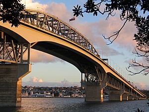
The suburb and Westhaven Marina seen under the Auckland Harbour Bridge from the North Shore.
|
|
| Country | New Zealand |
| Local authority | Auckland |
| Electoral ward | Waitematā and Gulf ward |
| Local board | Waitematā Local Board |
| Area | |
| • Land | 83 ha (205 acre) |
| Population
(June 2023)
|
|
| • Total | 2,060 |
|
|
||
Saint Marys Bay is a cool inner suburb in Auckland, New Zealand. It's located right next to the Waitematā Harbour, offering great views and a rich history. It's known for its beautiful old homes and its connection to the sea.
Contents
Who Lives in Saint Marys Bay?
Saint Marys Bay covers about 0.83 square kilometers. In the 2023 New Zealand census, about 2,049 people lived here. This means there are about 2,469 people living in each square kilometer.
| Historical population | ||
|---|---|---|
| Year | Pop. | ±% p.a. |
| 2006 | 2,169 | — |
| 2013 | 2,286 | +0.75% |
| 2018 | 2,205 | −0.72% |
| 2023 | 2,049 | −1.46% |
Most people living in Saint Marys Bay are from European backgrounds (about 86.5%). There are also people from Māori (7.3%), Asian (10.4%), and Pasifika (2.8%) backgrounds, along with others.
Most people (98.1%) speak English. Some also speak Māori (1.6%) and other languages. About 31.2% of the people living here were born in other countries.
The average age of people in Saint Marys Bay is around 48.7 years old. About 9.2% of the residents are under 15 years old, and 24.2% are 65 or older.
Many adults in Saint Marys Bay have a university degree or higher (52.1%). The average income here is higher than the national average, at about $63,800. Most adults (53.2%) work full-time.
A Look Back in Time: Saint Marys Bay History
The 1700s: Early Days
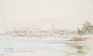
The area now called Point Erin, near the Auckland Harbour Bridge, was once a Māori village (called a pā) named Okā or Te Koraenga. Māori people used this spot as a fishing base, especially for catching sharks in summer. Saint Marys Bay itself was known as Ko Takere Haere, which means "the split canoe hull." This name comes from a story about a canoe that broke while being brought ashore.
The 1800s: Churches and New Homes
- Mid-1840s: A farmer named George Scott worked the land where the area known as Three Lamps is today.
- 1853: Catholic Bishop Pompallier bought a large piece of land (about 19 hectares) between Three Lamps and the coast. He named it Mount Saint Mary.
- 1854: A school for Māori girls, St. Anne's School, opened in James O’Neill's old house. It was run by the Sisters of Mercy, who came from Ireland and already spoke Māori.
- 1854: St. Mary's College for Catechists (people who teach about religion) moved to Ponsonby. A school for boys and a seminary (a school for training priests) were built.
- 1858: The first wooden Church of the Immaculate Conception was built.
- 1859: A new street was built through the Mount Saint Mary estate. Bishop Pompallier gave land for St. Mary's College. The Sisters built a three-story convent building, which opened in 1861. The only building left from this time is the Kauri St Mary's Chapel, built in 1865.
- 1860s: Many Roman Catholics bought land nearby to be close to the church, convent, and schools. This is why some street names, like "Dublin" and "Green," remind us of Ireland.
- 1860: Bishop Pompallier returned from Europe with French nuns. They started a new group called the Congregation of the Holy Family, focusing on teaching Māori girls.
- 1862: The Convent was finished, and the Holy Family order took over teaching at the school.
- 1862: The Bishop moved into O'Neill's old house as his home.
- 1863: The Bishop sold more land, keeping a smaller area with his house, the Church of the Holy Family, and the Holy Family Convent. The Nazareth Institute for Māori and Half-Caste Girls was started.
- 1866: St. Mary's Convent, with its dorms and chapel, was built.
- 1865–68: The Suffolk Hotel (now the Cavalier Tavern) was built on College Hill.
- 1869–70: The Holy Family Convent was destroyed by fire. The Bishop had to sell his remaining land, including his house. The new owner tore down the Church of the Immaculate Conception. The Bishop resigned and left, and the Holy Family order ended. St. Mary's Convent remained.
- 1873: Bishop Croke, the next Catholic Bishop of Auckland, bought back the land with the Bishop's House. In 1874, the wooden house was moved to its current spot at 57 St Marys Road.
- 1874: A farm called "Campbellville" was divided up to create new areas for homes.
- 1886–87: The Catholic Church of the Sacred Heart was built. It became the main church for the area, taking over from St Mary's Chapel.
- 1890s: Public toilets for men were built underground at Three Lamps. These might have been the first public toilets in Auckland!
- 1894: The new Bishop's Palace was built. It was designed by famous architects, the Pugin brothers. This large brick building was partly paid for by donations from all over the world. It's believed to be the first house in Auckland to have electric lights!
The 1900s: Modern Changes
- 1902: The Ponsonby Fire Station was built on St Marys Road.
- 1905: The Leys Institute was opened at Three Lamps. This grand building had a public library, a lecture hall, and a gym.
- 1911: The Ponsonby Post Office was built.
- 1912: The Shelly Beach Baths, a popular place for swimming in saltwater, were opened.
- 1950s: The coastline of Saint Marys Bay changed a lot when the motorway for the Auckland Harbour Bridge was built. Many small boatyards had to close. Local residents, including engineers and architects, helped create Westhaven Marina, which is now a major part of Auckland.
- 1959: The Auckland Harbour Bridge officially opened.
Getting Around Saint Marys Bay
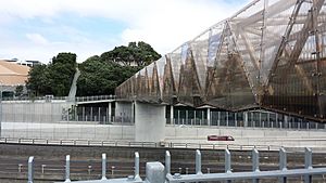
Saint Marys Bay used to have direct paths and roads leading down the cliffs to the water. However, when the motorway was built, most of these links disappeared. In 2012, the Jacobs Ladder Bridge was opened. This bridge goes over State Highway 1 and helps people walk to Westhaven Marina.
Schools in Saint Marys Bay
St Mary's College is a Catholic secondary school for girls (Years 7–13). As of 2023, it has about 50 students.
Other nearby schools include Auckland Girls' Grammar School and St Paul's College for boys, which is also a Catholic school.
Famous People from Saint Marys Bay
- The Catholic Bishop of Auckland: Every Bishop since Bishop Pompallier has lived in the Bishop's Palace in St Marys Bay.
- Sister Mary Leo: A very famous singing teacher who taught world-renowned opera singers like Dame Kiri te Kanawa and Dame Malvina Major.
 | Sharif Bey |
 | Hale Woodruff |
 | Richmond Barthé |
 | Purvis Young |


