
Auckland Harbour Bridge facts for kids
Quick facts for kids Auckland Harbour Bridge |
|
|---|---|
.jpg)
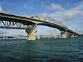
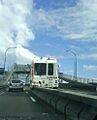
Auckland Harbour Bridge, seen from the North Shore looking toward Auckland City
|
|
| Coordinates | 36°49′46″S 174°44′47″E / 36.82944°S 174.74639°E |
| Carries | 8 lanes of New Zealand State Highway 1 (as the Auckland Northern Motorway) |
| Crosses | Waitematā Harbour |
| Locale | Auckland, New Zealand |
| Maintained by | NZ Transport Agency |
| Characteristics | |
| Design | Box truss |
| Material | Steel |
| Total length | 1,020 metres (3,350 ft) |
| Longest span | 243.8 metres (800 ft) |
| Number of spans | 9 |
| Load limit | 13 tonnes (13 long tons; 14 short tons) on outside lanes |
| Clearance above | 4.8 metres (16 ft) |
| Clearance below | 43.27 metres (142.0 ft) at high tide |
| History | |
| Designer | Freeman Fox & Partners |
| Constructed by | Dorman Long and Cleveland Bridge & Engineering Company |
| Construction begin | 1954 |
| Construction end | April 1959 |
| Opened | 30 May 1959 |
| Statistics | |
| Toll | Until 31 March 1984 |
The Auckland Harbour Bridge is a large bridge in Auckland, New Zealand. It has eight lanes for cars and trucks. The bridge crosses the Waitematā Harbour, connecting St Marys Bay in Auckland city with Northcote on the North Shore. It is an important part of State Highway 1.
The bridge is managed by the NZ Transport Agency (NZTA). It is the second-longest road bridge in New Zealand. It is also the longest road bridge in the North Island.
The first four lanes of the bridge opened in 1959. They were built using a strong "box truss" design. Later, in 1968–1969, two more lanes were added to each side. These new lanes are supported by the original bridge structure. The bridge is 1,020 metres (3,348 feet) long. Its main section spans 243.8 metres. It rises 43.27 metres above the water at high tide. This height allows ships to pass underneath to places like the Chelsea Sugar Refinery.
Many people see the Auckland Harbour Bridge as a symbol of the city. However, some have said it looks similar to the Sydney Harbour Bridge. When it was built, there were no paths for walking, cycling, or trains. This is seen as a missed opportunity by many. But in 2016, a plan called "SkyPath" was approved. This plan would add a path for walkers and cyclists to the bridge.
Around 170,000 vehicles cross the bridge every day (as of 2019). This includes over 1,000 buses. These buses carry many people during busy morning times.
Contents
Why the Bridge Was Built
Before the bridge opened in 1959, getting from Auckland city to the North Shore was difficult. People usually took a ferry for passengers or cars. Driving was a very long trip, about 50 kilometres (31 miles). It meant going far inland through places like Massey and Albany.
As early as 1860, an engineer named Fred Bell suggested building a bridge. Farmers on the North Shore wanted to bring their animals to market in Auckland. His idea involved floating sections, but it was too expensive at the time.
In the 1950s, when the bridge was being planned, the North Shore was mostly countryside. Only about 50,000 people lived there. There were not many jobs. The bridge was built to help the area grow. It opened up the North Shore for more homes and businesses.
Building the Bridge
The First Structure
When the bridge was designed, it was meant to have five or six lanes. It was also supposed to have footpaths for people to walk on. However, to save money, these features were removed. The government decided on a simpler four-lane design without footpaths. This decision has been called a "penny-pinching" mistake.

The bridge took four years to build. The main companies that built it were Dorman Long and the Cleveland Bridge & Engineering Company. Hundreds of workers were involved, including 180 people from the UK. Work sometimes slowed down because of worker strikes in 1956 and 1957.
Large steel sections of the bridge were put together first. Then, they were floated into place on special barges. Once, during a storm, one of the main sections almost drifted away. But a tugboat called William C Daldy managed to hold it in place for 36 hours against strong winds.
The bridge was finished in April 1959, ahead of schedule. It was officially opened on May 30, 1959, by the Governor-General, Lord Cobham. Before the official opening, a special day was held where 106,000 people walked across the new bridge.
Sadly, three or four workers died in accidents during the construction. The names of three of them are on a memorial plaque under the bridge on the Northcote side.
The bridge was paid for with government loans. It started as a toll bridge, meaning drivers had to pay to cross it. This was the first toll bridge in New Zealand. Toll booths were at the northern end. The toll was removed on March 31, 1984. This happened because the government had promised to stop charging tolls once the building costs were paid off.
The 'Nippon Clip-ons'

The bridge was first built with four lanes. But the North Shore grew very quickly, and traffic increased a lot. By 1965, about 10 million vehicles used the bridge each year. This was three times more than expected!
So, in 1969, just ten years after it opened, two extra lanes were added to each side. These new sections are called "clip-ons." They were made by a Japanese company called Ishikawajima-Harima Heavy Industries. Because of this, they were nicknamed the 'Nippon clip-ons'. Choosing a Japanese company was a big step at the time, as it was only 20 years after World War II. Adding these lanes later cost much more than if they had been built from the start.
The clip-ons have had some problems over the years. In 1987, they needed major repairs because of cracks. In 2006, more cracks were found. The clip-ons were originally expected to last 50 years. To keep them safe, in 2007, a rule was made to ban very heavy vehicles (over 13 tonnes) from the outside lanes of the clip-ons.
In 2007, NZ$45 million was spent on maintenance work for the clip-ons. In 2008, it was suggested that trucks might need to be banned from all clip-on lanes. This was to make sure the bridge could last longer. In 2009, the cost of fixing the clip-ons increased further. After these repairs, the clip-ons are expected to last another 20 to 40 years.

Managing Traffic

The bridge uses a "tidal flow" system to manage traffic. This means the direction of the two middle lanes changes depending on the time of day. During the busy morning rush, five of the eight lanes are for traffic heading south into the city. In the afternoon, five lanes are for traffic heading north to the North Shore. At other times, the lanes are split evenly.
For many years, overhead signals showed which way the lanes were going. But in the late 1980s, some serious head-on crashes happened. Drivers sometimes crossed into oncoming traffic. So, in 1990, a special movable concrete barrier was put in place. This barrier separates traffic going in opposite directions. It helped stop head-on accidents.
Two special machines move this concrete barrier. They shift it by one lane four times a day. It takes about 40 minutes to move the barrier. This was the first system of its kind in the world. In 2009, newer machines and a slightly narrower barrier were installed. The new machines can move the barrier in half the time.
Events on the Bridge
Sometimes, for big events like the Auckland Marathon, people are allowed to walk or cycle on the bridge. In December 2011, cyclists were officially allowed on the bridge for a race. This was the first time cyclists could use the bridge. Buses were used to create a "guard of honour" to protect the cyclists from other traffic.
Proposed Walk and Cycleway

Original Idea
When the bridge was first built, paths for walking and cycling were removed to save money. They were not added when the clip-ons were built either. Today, people can only walk on the bridge as part of special guided tours.
In 2007, there were talks about adding a path for cyclists and walkers. It was estimated to cost between NZ$20 million and $40 million. However, many people supported the idea. Groups like GetAcross and Cycle Action Auckland argued that cheaper options were possible. They believed a path could be added during the bridge strengthening work.
The GetAcross group proposed a solution called SkyPath. It would be a walking and cycling path attached to the bridge.
Protests

On May 24, 2009, thousands of people walked across the bridge as a protest. The GetAcross group organised it because they wanted walking and cycling access. The NZTA had forbidden the crossing due to safety and traffic concerns. After some speeches, many people walked onto the bridge. Police then closed the northbound lanes to traffic. No accidents or arrests were reported. The protesters left the bridge about an hour later.
This protest caused a lot of discussion. Some people thought it was dangerous. Others saw it as a successful way to show authorities that many people wanted a walk and cycleway.
Updated Proposal and Approval
Because of the high costs and problems with the clip-ons, the GetAcross group suggested a new idea in 2009. They proposed a single path for walking and cycling hung under the eastern clip-on. This clip-on has more spare strength. This new idea would not need to widen the bridge. It was estimated to cost around NZ$12 million.
The group suggested raising most of the money through a loan. This loan would be paid back by small tolls, like NZ$1 for regular users. The NZTA said they would consider the idea if funding could be found.
In 2011, the idea gained more support. Auckland Mayor Len Brown agreed that a walk and cycleway was a good goal. He asked Auckland Transport to make it a priority. Several city organisations also supported the plan.
In 2014, the proposed walk and cycleway was officially announced. It received approval in 2015. Although there were some appeals, the decision was upheld in 2016. The Auckland Council also approved a plan for public and private groups to fund it together.
In 2019, it was announced that work on the walking and cycling "clip-on" could start in 2020.
Bridge Utilities
The bridge also carries important services. These include pipes for water and gas. It also has fibre-optic cables for telecommunications.
In 2012, Transpower installed three large 220,000-volt power cables on the bridge. These cables connect power stations in Auckland city to the North Shore.
Bungy Jumping
Bungy jumping is available from the bridge. The company AJ Hackett runs a 40-metre (131-foot) bungy jump. They also offer a bridge climb. This climb gives amazing views of the city and harbour.
Second Harbour Crossing

Almost as soon as the bridge was full of traffic, people started talking about a second crossing. This was even before the clip-ons were added. Building another crossing is very expensive. It is also hard to connect it to the existing road network. Because of this, plans are still just ideas.
In 2008, a study looked at many options. They decided on a plan for multiple tunnels. These tunnels would be about one kilometre east of the bridge. They could have separate tunnels for cars, public transport, and trains. This plan has not yet been approved or funded. However, the areas needed for the tunnels are being protected. This ensures they can be built in the future.
2020 Bridge Damage
In September 2020, strong winds caused a heavy truck to tip over and crash into the bridge structure. This caused significant damage. Temporary repairs were made quickly. A new, permanent support piece was installed on October 4, 2020. All lanes of the bridge were open again on October 7, 2020.
Images for kids
-
Auckland Harbour Bridge, seen from the North Shore looking toward Auckland City
-
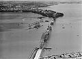
The bridge under construction in 1958
-
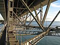
Support structure under the bridge
-
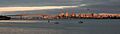
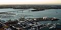
The Auckland CBD skyline and Harbour Bridge at sunset
-
The barrier transfer machine moving the barrier for the afternoon/evening traffic rush
-
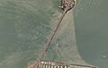
Auckland Harbour Bridge seen from above.
-
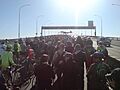
Protesters in favour of a walk and cycleway surge onto the bridge, May 2009.
-
The bridge north-west from the Sky Tower
See Also
- Cycling in Auckland
- Second Harbour Crossing, Auckland
- North Auckland and Northland grid upgrade project
