North Shore, New Zealand facts for kids
Quick facts for kids
North Shore
|
|
|---|---|

The North Shore captured by a Planet Labs satellite in 2016
|
|
| Country | New Zealand |
| Island | North Island |
| Region | Auckland Region |
| Area | |
| • Total | 116.64 km2 (45.03 sq mi) |
| Population
(June 2023 )
|
|
| • Total | 248,997 |
| • Density | 2,134.75/km2 (5,528.97/sq mi) |
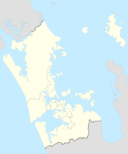
The North Shore (also known as Māori: Te Whenua Roa ō Kahu or Māori: Te Raki Paewhenua) is a large area in Auckland, New Zealand's biggest city. It covers the northern side of the Waitematā Harbour and stretches north to the Ōkura River.
This area was formed mostly from sandstone that was pushed up from the sea floor millions of years ago. It also has some of the oldest volcanoes in Auckland, like Lake Pupuke. Māori people settled here in the 1200s or 1300s. The harbour was important for gathering food and for travel. European settlers arrived in the 1840s. By the early 1900s, the inland areas grew fruit, and the eastern coast became a popular holiday spot.
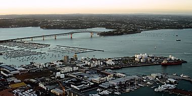
The North Shore grew very quickly after the Auckland Harbour Bridge was built in 1959. In 1989, five local councils joined together to form North Shore City. This city existed until 2010.
Contents
What is the North Shore?
The name "North Shore" has been used since 1843. It generally means the land north of the Waitematā Harbour, reaching up to Lucas Creek and Ōkura River. Some other places like Pāremoremo and Dairy Flat are also part of the North Shore. North Shore Aerodrome is located in Dairy Flat.
Important towns and suburbs on the North Shore include Albany, Birkenhead, Browns Bay, Devonport, Glenfield, Northcote, and Takapuna.
Māori Names for the North Shore
The two main Māori names for the North Shore are Te Whenua Roa o Kahu and Te Raki Paewhenua.
- Te Whenua Roa o Kahu means "The Greater Lands of Kahu." Kahu was the granddaughter of Maki, an important ancestor of the Te Kawerau ā Maki tribe.
- Te Raki Paewhenua has been used since the 1980s. You can find this name in local organisations like schools and health services.
In the mid-1800s, Māori texts often used the names Takapuna or Awataha to describe the North Shore. Takapuna was originally the name of a spring at Maungauika / North Head. Over time, it came to mean the wider southern North Shore area.
Geology of the North Shore
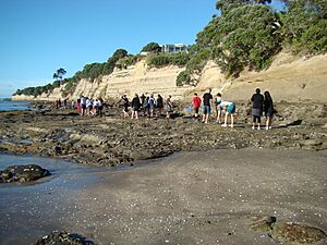
The North Shore is mostly made of Waitemata Group sandstone. This rock formed on the sea floor about 22 to 16 million years ago during the Miocene epoch. Later, movements in the Earth's crust pushed these layers upwards. You can clearly see these layers in the cliffs along the Hauraki Gulf.
The very oldest rocks underneath are called greywacke and argillite. Some headlands are made of harder Parnell grit rocks. These formed from lahars, which are like mudflows from volcanoes, also during the Miocene.
Volcanic Features
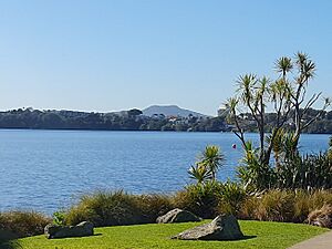
The North Shore has the northernmost volcanoes of the Auckland volcanic field.
- Lake Pupuke in Takapuna is a volcanic maar (a wide, flat-bottomed crater). It's one of the oldest volcanoes in Auckland, erupting around 193,200 years ago. When it erupted, lava flowed east, burning trees and covering their lower trunks. This lava turned into hard basalt rock, creating the Takapuna Fossil Forest. This forest was uncovered about 7,000 years ago by coastal erosion.
- There are two other volcanic maars on the eastern coast of Northcote: Tank Farm (also called Tuff Crater or Te Kōpua ō Matakamokamo) and Onepoto (Te Kōpua ō Matakerepo). They erupted around 187,600 and 181,000 years ago.
- In Devonport, you'll find three volcanic features: Takarunga / Mount Victoria, which is the highest volcano on the North Shore at 81 metres. There's also Maungauika / North Head, a headland at the entrance to the Waitematā Harbour. The third, Takararo / Mount Cambria, was completely quarried away by the 1970s. Maungauika / North Head is the oldest of these, erupting about 87,000 years ago. Takararo / Mount Cambria erupted around 43,000 years ago, and Takarunga / Mount Victoria around 35,000 years ago.
Even though it's not on the North Shore, the 260-metre-high Rangitoto Island is a famous landmark. It's the youngest volcano in the Auckland field, erupting around the year 1500.
Geography of the North Shore
The North Shore is a large suburban area north of downtown Auckland. It's connected to the rest of Auckland by two bridges: the Auckland Harbour Bridge and the Upper Harbour Bridge.
In the past, the North Shore was governed by the North Shore City Council. However, on 1 November 2010, this council and six other local councils joined with the Auckland Regional Council to form the single Auckland Council.
The former North Shore City area was bordered by the Rodney District to the north, the Waitematā Harbour to the south, and the Rangitoto Channel (part of the Hauraki Gulf) to the east. The main office of the council was in Takapuna.
Today, the North Shore is divided into four local board areas under the Auckland Council: Devonport-Takapuna, Kaipatiki, Upper Harbour, and Hibiscus and Bays.
Some of the inner suburbs include Milford, Takapuna, Belmont, Devonport, Bayswater, Northcote, Birkenhead, Highbury, Hillcrest, Glenfield, Wairau Valley, Westlake, and Forrest Hill.
Outer suburbs include Birkdale, Beach Haven, North Harbour, Albany, Greenhithe, Long Bay, Torbay, Waiake, Browns Bay, Rothesay Bay, Murrays Bay, Mairangi Bay, Campbells Bay, Sunnynook, and Castor Bay. Many of the beaches on the Hauraki Gulf coast are known as the East Coast Bays.
Flora of the North Shore
Before people settled here, the inland North Shore was covered in thick native forests. These forests had large trees like kauri, tōtara, mataī, miro, and kahikatea. Along the coast, Pōhutukawa trees were very common. By the 1800s, much of the North Shore had become scrubland, with plants like mānuka, tutu, harakeke flax, and ferns.
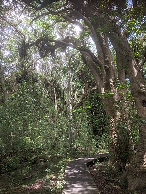
Today, some small parts of the original kauri forest still exist around Birkenhead, such as Kauri Park and Le Roys Bush. Smiths Bush in the Onewa Domain is another native forest with many kahikatea and taraire trees. Fernhill Escarpment in Albany has very old tōtara trees, some estimated to be 800 years old.
In 1974, Graeme Platt started New Zealand's first business that grew native plants. Many of his plants came from the Albany area. This means that many native plants grown across New Zealand in the 1970s and 1980s originally came from North Shore forests. One example is the tōtara plant called Aurea, also known as Albany Gold.
History of the North Shore
For a long time, the North Shore was a very rural area. People from Auckland City would often visit on weekends to enjoy the beaches. Ferries connected the North Shore to Auckland. By the 1950s, only about 50,000 people lived there. The area didn't grow as fast as other parts of Auckland because there weren't many jobs.
This all changed when the Auckland Harbour Bridge was built in 1959. The bridge made it much easier to travel to the North Shore, which then became a popular place for people who worked in Auckland to live. The number of cars using the bridge grew much faster than expected. The North Shore grew so much that it became its own city. However, it still has fewer people living close together compared to areas south of the harbour.
On 1 November 2010, the North Shore's local government changed. The North Shore City Council was replaced by the new Auckland Council, which now manages all council services for the entire Auckland Region.
North Shore Population
The North Shore covers 116.64 square kilometres. As of June 2023, it has an estimated population of 248997 people.
| Historical population | ||
|---|---|---|
| Year | Pop. | ±% p.a. |
| 2006 | 203,400 | — |
| 2013 | 221,682 | +1.24% |
| 2018 | 238,629 | +1.48% |
| 2023 | 244,515 | +0.49% |
| The 2006 population is for a smaller area of 114.27 km2. | ||
In the 2023 New Zealand census, the North Shore had a population of 244,515. This was an increase of 5,886 people (2.5%) since the 2018 census.
About 18% of the people were under 15 years old, and 19.5% were aged 15 to 29. Most people (47.8%) were between 30 and 64 years old, and 14.7% were 65 or older.
People could choose more than one ethnic group. The results showed that 58.6% were European (Pākehā), 6.9% were Māori, 3.9% were Pasifika, and 35.4% were Asian.
English was spoken by 92.1% of people. Other languages were spoken by 34.2%. About 55.1% of people said they had no religion, while 31.4% identified as Christian.
Many people on the North Shore have higher education. About 39% of people aged 15 or older had a bachelor's degree or higher. Most people (53.9%) were employed full-time.
Transportation in the North Shore
It's fairly easy to travel within the North Shore. However, if you need to go to Auckland's city centre, crossing the Auckland Harbour Bridge can mean heavy traffic, especially during busy times. The other route through the western suburbs also gets very busy. There has been a lot of talk about how to fix this traffic problem, but building new bridges or tunnels is very expensive and difficult.
The Northern Busway is a special bus lane that runs next to the Northern Motorway. It helps people on the North Shore and Hibiscus Coast travel faster by bus. There are also "park and ride" stations where people can leave their cars and take the bus. The busway has been fully working between Constellation and Akoranga since 2008.
Many North Shore suburbs have a regular ferry service to Auckland's city centre. These include Devonport, Stanley Bay, Bayswater, and Birkenhead. There are also plans for ferry services from Takapuna and Browns Bay.
Economy of the North Shore
The North Shore has over 22,000 businesses. These businesses contribute more than 6% to New Zealand's total economy. Between 1998 and 2002, the North Shore had the fastest growth in new businesses in the country, increasing by 29.3%.
The suburb of Albany has become the main business area of the North Shore. Many large stores, like those from Westfield, have built "super stores" there. This is because people expect the area to keep growing. Albany has also seen a lot of new, more affordable homes being built. Thousands of acres of farmland have been turned into new neighbourhoods with many similar houses. Because of this, Albany has attracted hundreds of millions of dollars in investment.
The Royal New Zealand Navy has its main base in Devonport. This base is a big employer and an important part of the local economy.
New homes are still being built very quickly, spreading northwards from the North Shore. Places like Orewa and the Whangaparāoa Peninsula, which are about 25 kilometres north of Takapuna, used to be holiday spots. Now, they are connected by the Northern Motorway and might eventually become part of the continuous urban area of the North Shore.
Some areas on the North Shore have some of the most expensive homes in New Zealand. The coastal area from Takapuna Beach to Milford is often called the "Golden Mile." Many properties here have sold for millions of dollars. This is because of the beautiful beaches, Lake Pupuke, popular schools, and shopping centres like Shore City. In 2005, one beachfront property sold for $12.8 million. Rent and property prices on the North Shore are generally high compared to other parts of New Zealand.
Television
The North Shore is the setting for New Zealand's most popular TV soap opera, Shortland Street. While it used to be filmed mostly there, some scenes are still set on the North Shore. Go Girls is another popular show that takes place on the North Shore. The Prime TV channel has its studios in Albany.
Sports
The North Shore is home to the North Harbour Rugby Union, which has a team in the Mitre 10 Cup. Their home ground is North Harbour Stadium in Albany. The North Shore Rugby Football Club, based in Devonport, is the oldest rugby union club in the Auckland Region and one of the oldest in New Zealand. The North Shore is also where North Shore United, founded in 1886, plays. It is the oldest surviving association football (soccer) club in New Zealand.
Notable people
- Judy Bailey – retired television newsreader
- Dean Barker – yachtsman
- Robert Berridge – professional boxer
- Stephen Berry – politician and political commentator
- Sir Peter Blake – yachtsman
- Nick Evans – rugby player
- Ian Ferguson – canoeist, Olympic gold medalist
- John Hood – former vice-chancellor of the University of Oxford and University of Auckland
- Rachel Hunter – model and actress
- Ian Jones – rugby union player
- Lorde – singer/songwriter
- Sean Marks – basketball player
- Luke McAlister – rugby union player
- Peter Montgomery – sports broadcaster
- Danny Morrison – cricketer
- Kirk Penney – basketball player
- Winston Reid – footballer
- Frank Sargeson – writer
- Wayne "Buck" Shelford – rugby player
- Pamela Stephenson, Lady Connolly – psychologist, writer, actress, comedian, wife of Billy Connolly
- Bert Sutcliffe – cricketer
- Rosita Vai – New Zealand Idol winner
- Richard Fairgray – author and illustrator
Panorama
See also
 In Spanish: North Shore (Auckland) para niños
 | Leon Lynch |
 | Milton P. Webster |
 | Ferdinand Smith |


