
Mount Victoria (Auckland) facts for kids
Quick facts for kids Takarunga |
|
|---|---|
| Mount Victoria | |

Takarunga / Mount Victoria as seen from the south on the Waitematā Harbour, the Devonport ferry terminal in the middle distance.
|
|
| Highest point | |
| Elevation | 66 m (217 ft) |
| Geography | |
| Location | North Island, New Zealand |
| Geology | |
| Volcanic arc/belt | Auckland volcanic field |
Takarunga / Mount Victoria is the tallest volcano on Auckland's North Shore. It stands 66 meters high. Its age is currently unknown. The lava flows from this volcano now form much of the Devonport waterfront. Takarunga was once an important pā (a fortified village) used by Tāmaki Māori people. In the late 1800s, a gun fort was built on top of the hill. This fort helped defend the city of Auckland. Since 2014, Takarunga has been managed by the Tūpuna Maunga Authority. This group looks after 14 special mountains across Auckland.
Contents
Exploring Takarunga / Mount Victoria
This hill offers amazing views of Auckland's Waitematā Harbour and the inner Hauraki Gulf. Over the years, the top of the hill has been used for many things. It was a signal station for ships. It also had places for artillery (large guns) and concrete army bunkers. Some of these bunkers date back to the 1870s. One old bunker is now a place where the Devonport Folk Music Club meets.
The slopes of Takarunga / Mount Victoria are also home to Devonport Primary School. You can find a playcentre, tennis courts, and a cemetery here too. There is also a large water reservoir that supplies water to the area. It's a great spot for a scenic lookout! The old Signalman's House is now the Michael King Writers Centre. This centre helps writers by offering special programs and workshops.
A Look at Takarunga's History
An important pā (fortified village) once stood on the slopes of Takarunga. You can still see some of the old earthworks from this settlement. In the 1700s, Waiohua chief Kiwi Tāmaki used Takarunga seasonally. He came here to catch and preserve birds.
The traditional Māori name, Takarunga, means "The Hill Standing Above." This name is different from Mount Cambria, another nearby hill. Mount Cambria was known as Takararo, meaning "The Hill Standing Below." A smaller hill made of scoria (volcanic rock) called Duders Hill was mostly quarried away. It was located on Takarunga's southern slopes.
French explorer Jules Dumont d'Urville climbed the hill in 1827. Later, early European settlers named it Mount Victoria after Queen Victoria.

In 1841, a signal station was built on the peak. This helped guide ships coming into the Port of Auckland. In 1880, the hill became a public park. In 1885, a gun fort was built on the peak. This fort was used until after World War II.
How the Land is Managed Today
In 2014, a special agreement was made. This was part of the Treaty of Waitangi settlement between the Crown and 13 Auckland iwi and hapu (Māori tribes and sub-tribes). This group is also known as the Tāmaki Collective.
Through this agreement, ownership of 14 Tūpuna Maunga (ancestral mountains) in Auckland was given to the collective. Takarunga / Mount Victoria was one of these mountains. The law states that the land should be held in trust. This means it is for the benefit of both the Tāmaki Collective and all other people of Auckland.
The Tūpuna Maunga Authority (TMA) was created to manage these 14 Tūpuna Maunga. It is a co-governance group. The Auckland Council helps manage the Tūpuna Maunga under the direction of the TMA.
Gallery
-
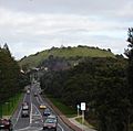
The north side of Takarunga / Mount Victoria, seen from Lake Road
-
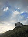
The Bunker, home of the Devonport Folk Club
-
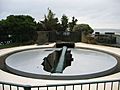
BL 8 inch Mk VII Disappearing gun at the summit of Takarunga / Mount Victoria
-
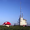
'Mushrooms' on top of the hill, which are in fact vents for a water pumping station


