Auckland volcanic field facts for kids
Quick facts for kids Auckland Volcanic Field |
|
|---|---|
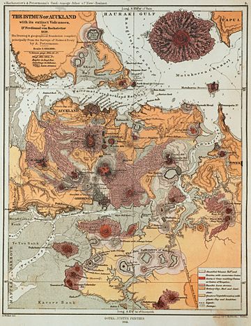
Map of the field drawn by Hochstetter in 1859 and published in English in 1864
|
|
| Highest point | |
| Elevation | 260 m (850 ft) |
| Geology | |
| Age of rock | Pleistocene and Holocene |
| Mountain type | Volcanic Field |
| Type of rock | Basalt |
| Last eruption | c. 1400 CE |
The Auckland volcanic field is a special area in Auckland, New Zealand. It is home to many different volcanoes. Auckland is the largest city in New Zealand, located on the North Island.
This area has about 53 volcanoes. Each volcano has erupted only once. They have created various landforms like big holes (called maars), flat rings of ash (tuff rings), rocky hills (scoria cones), and rivers of hardened rock (lava flows).
Even though each volcano erupts only once, an eruption can last for weeks or even years. The volcanoes here are fed by a type of molten rock called basaltic magma. This is different from the powerful, explosive volcanoes in the central North Island, like Mount Ruapehu and Lake Taupō. The Auckland volcanic field is currently quiet, or dormant. But it could become active again in the future.
Contents
What Makes the Auckland Volcanic Field Special?
The volcanic field stretches across a large area. It goes from Lake Pupuke and Rangitoto Island in the north. It reaches Matukutururu (Wiri Mountain) in the south. From west to east, it spans from Mount Albert to Pigeon Mountain.
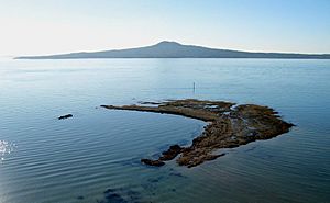
The first volcano to erupt in this field was at Pupuke. This happened about 193,200 years ago. The most recent eruption was about 600 years ago. This was Rangitoto, an island volcano just east of the city. It was a huge eruption, sending out 0.7 cubic kilometres of lava. Rangitoto is much bigger than the other volcanoes. It makes up 41% of all the material that has erupted from the field. Most of the volcanoes in the field are quite small, usually less than 150 metres (490 feet) tall.
Lake Pupuke, near Takapuna, is a large hole made by a volcanic explosion. Other similar craters, like Orakei Basin, are now open to the sea.
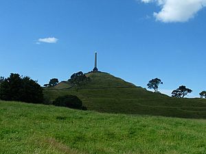
The volcanoes have also created many large lava flows. These flows cover much of the Auckland area. One of the longest flows goes from Mt Saint John northwards. It almost crosses the Waitematā Harbour to form Meola Reef. More than 50 lava tubes (underground tunnels made by flowing lava) and other lava caves have been found. One example is the 290-metre (950-foot) long Wiri Lava Cave. Another long cave is the Cave of a Thousand Press-ups, near Maungakiekie/One Tree Hill. There are also impressive dips in the ground where lava caves have collapsed. These include the Puka Street Grotto and Hochstetter Pond in Onehunga.
For most of the last 200,000 years, the Earth has been in ice ages. During these times, sea levels were much lower because a lot of water was frozen in ice. The Waitemata and Manukau Harbours were dry land. Most volcanoes likely erupted on land. Rangitoto is an exception, as it erupted during the current warmer period between ice ages.
Volcanoes and People
How People Have Used the Volcanoes
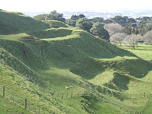
Many of the volcanic hills were once home to large Māori pā. These were fortified villages. You can still see terraces and other signs of these old settlements today. Many of the cones have been flattened or changed a lot. This was partly due to Māori use, but mostly because of recent quarrying. Quarrying is when rocks, especially scoria, are dug out for building materials.
However, several remaining volcanoes are now protected. They are important landmarks and parks. A law from 1915 helps protect these cones. This law was passed because people were worried that the unique landscape was being destroyed. This law has helped prevent big changes to places like Mount Roskill.
In 2007, New Zealand suggested that the Auckland volcanic field become a World Heritage Site. This is because it has a special mix of natural and cultural features. At that time, only 2% of World Heritage Sites were in this "mixed" category.
What Are the Dangers?
The volcanic field is not extinct, meaning it could erupt again. New volcanic events could happen at any time. Usually, there are hundreds or thousands of years between eruptions. However, if a big eruption happened, the effects would be serious. These could include fast-moving clouds of hot gas and ash (pyroclastic surges), earthquakes, flying rocks (lava bombs), ash falling from the sky, and volcanic gases. There could also be lava flows.
These effects might last for several months. They could cause a lot of damage and disruption. Homes and businesses could be buried. Important parts of the country's transport system, like the Port of Auckland, the State Highway network, or the Auckland Airport, might have to close. It's even possible that several volcanoes could erupt at the same time. There is evidence that eight volcanoes erupted within a 3,000-year period, between 31,000 and 28,000 years ago.
To prepare for volcanic activity, special plans and systems are in place. The Auckland Regional Council has an 'Auckland Volcanic Field Contingency Plan'. This plan helps civil defence and emergency services work together during an eruption. Auckland also has a network of six seismometers. These devices detect small tremors that usually happen before a volcanic eruption. This system could give people a few hours to several days of warning before an eruption, and help pinpoint its location.
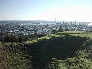
The Auckland War Memorial Museum, which is built on the edge of the Pukekawa crater, has an exhibition about the volcanic field. It includes a "Puia Street multi-sensory visitor experience" that makes you feel like you're watching an eruption in Auckland.
In 2013, scientists found that Rangitoto was much more active in the past than they first thought. It was active on and off for about 1,000 years before its final eruptions around 550 years ago. Civil Defence officials said this discovery doesn't make living in Auckland more dangerous. However, it does change how they might plan an evacuation if needed.
List of Volcanoes
The volcanoes within the field are:
| Volcanoes | Age (thousand years) | Height | Location (Coordinates) | Refs | Images |
|---|---|---|---|---|---|
| Albert Park Volcano | 145 | Unclear | 36°51′03″S 174°46′03″E / 36.8507°S 174.7675°E | ||
| Ash Hill | 30.5 | 30 metres (98 ft) | 37°00′10″S 174°52′03″E / 37.002754°S 174.867545°E | ||
| Boggust Park Crater | 130 | 5 metres (16 ft) | 36°57′19″S 174°48′49″E / 36.955413°S 174.813552°E | ||
| Cemetery Crater | Unknown | 33 metres (108 ft) | 36°59′23″S 174°50′28″E / 36.989828°S 174.841082°E | ||
| Crater Hill | 30.5 | 36°59′12″S 174°49′38″E / 36.986546°S 174.827135°E | |||
| Grafton Volcano | 100 | 36°51′30″S 174°45′49″E / 36.858440°S 174.763624°E | |||
| Hampton Park | Unknown | 35 metres (115 ft) | 36°57′03″S 174°53′44″E / 36.950925°S 174.89544°E | ||
| Kohuora | 30.5 | 36°58′43″S 174°50′34″E / 36.97873°S 174.842691°E | |||
| Mangere Lagoon | 50 | 36°57′25″S 174°46′39″E / 36.95702°S 174.77763°E | |||
| Matanginui/Green Mount | 20 | 78 metres (256 ft) | 36°56′24″S 174°53′54″E / 36.939911°S 174.898267°E | ||
| Matukutureia/McLaughlins Mountain | 50 | 73 metres (240 ft) | 37°00′49″S 174°50′46″E / 37.013511°S 174.845974°E | ||
| Maungakiekie/One Tree Hill | 60 | 182 metres (597 ft) | 36°54′0″S 174°46′59″E / 36.90000°S 174.78306°E | ||
| Maungarahiri/Little Rangitoto | 24.5 | 75 metres (246 ft) | 36°52′31″S 174°48′35″E / 36.875407°S 174.809636°E | ||
| Maungarei/Mount Wellington | 10 | 135 metres (443 ft) | 36°53′35″S 174°50′47.6″E / 36.89306°S 174.846556°E | ||
| Maungataketake/Elletts Mountain | 90 | 76 metres (249 ft) | 36°59′41″S 174°44′51″E / 36.994635°S 174.747548°E | ||
| Maungauika/North Head | 90 | 50 metres (160 ft) | 36°49′40″S 174°48′43″E / 36.827751°S 174.81205°E | ||
| Maungawhau/Mount Eden | 28 | 196 metres (643 ft) | 36°52′37″S 174°45′50″E / 36.877°S 174.764°E | ||
| Motukorea/Browns Island | 24 | 68 metres (223 ft) | 36°49′50″S 174°53′41″E / 36.8306°S 174.8948°E | ||
| Mount Robertson/Sturges Park | 24 | 78 metres (256 ft) | 36°56′55″S 174°50′30″E / 36.948477°S 174.841726°E | ||
| Ōhinerau / Mount Hobson | 34 | 143 metres (469 ft) | 36°52′40″S 174°47′10″E / 36.877814°S 174.786156°E | ||
| Ohuiarangi/Pigeon Mountain | 24.5 | 55 metres (180 ft) | 36°53′20″S 174°54′11″E / 36.888846°S 174.903116°E | ||
| Orakei Basin | 120 | Sea level | 36°52′02″S 174°48′47″E / 36.867124°S 174.81308°E | ||
| Otahuhu/Mount Richmond | 30 | 50 metres (160 ft) | 36°55′57″S 174°50′22″E / 36.932562°S 174.839451°E | ||
| Ōtuataua | 15 | 64 metres (210 ft) | 36°59′10″S 174°45′15″E / 36.98611°S 174.75417°E | ||
| Ōwairaka / Mount Albert | 120 | 135 metres (443 ft) | 36°53′26″S 174°43′12″E / 36.890475°S 174.720097°E | ||
| Puhinui Craters | 50 | 22 metres (72 ft) | 37°00′53″S 174°49′59″E / 37.01465°S 174.83296°E | ||
| Pukaki Lagoon | 65 | Sea Level | 36°58′59″S 174°48′37″E / 36.982998°S 174.810226°E | ||
| Pukeiti | 15 | 30 metres (98 ft) | 36°59′02″S 174°45′26″E / 36.983756°S 174.757183°E | ||
| Pukekawa/Auckland Domain | 100 | 36°51′33″S 174°46′33″E / 36.859158°S 174.775808°E | |||
| Puketāpapa / Mount Roskill | 105 | 110 metres (360 ft) | 36°55′S 174°44′E / 36.917°S 174.733°E | ||
| Pukewairiki | 130+ | 30 metres (98 ft) | 36°56′39″S 174°51′57″E / 36.944078°S 174.865887°E | ||
| Pupuke | 190 | −57 metres (−187 ft) | 36°46′48″S 174°45′58″E / 36.780115°S 174.766184°E | ||
| Rangitoto Island | 0.6 | 260 metres (850 ft) | 36°47′12″S 174°51′36″E / 36.786742°S 174.860115°E | ||
| Rarotonga / Mount Smart | 20 | 87 metres (285 ft) (quarried) | 36°55′6″S 174°48′45″E / 36.91833°S 174.81250°E | ||
| Styaks Swamp | 20 | 36°56′10″S 174°54′01″E / 36.936138°S 174.900155°E | |||
| Takaroro / Mount Cambria | 40 | 30 metres (98 ft) (quarried) | 36°49′28″S 174°48′07″E / 36.824444°S 174.801933°E | ||
| Takarunga / Mount Victoria | 35 | 87 metres (285 ft) | 36°49′36″S 174°47′56″E / 36.8266°S 174.7990°E | ||
| Taurere / Taylors Hill | 30 | 56 metres (184 ft) | 36°51′51″S 174°52′12″E / 36.864223°S 174.869943°E | ||
| Te Apunga-o-Tainui / McLennan Hills | 41 | 45 metres (148 ft) (quarried) | 36°55′45″S 174°50′47″E / 36.929208°S 174.846468°E | ||
| Te Hopua-a-Rangi / Gloucester Park | 20+ | Sea level (reclaimed) | 36°55′46″S 174°47′05″E / 36.9295°S 174.784734°E | ||
| Te Kopua Kai-a-Hiku / Panmure Basin | 25 | Sea level | 36°54′18″S 174°50′58″E / 36.90495°S 174.849343°E | ||
| Te Kopua-o-Matakamokamo / Tank Farm | 180 | 36°48′07″S 174°45′12″E / 36.8020°S 174.7533°E | |||
| Onepoto | 185 | 36°48′29″S 174°45′03″E / 36.80818°S 174.75085°E | |||
| Te Kōpuke / Mount Saint John | 75 | 126 metres (413 ft) | 36°53′00″S 174°46′49″E / 36.883431°S 174.780196°E | ||
| Te Motu-a-Hiaroa/Puketutu | 30 | 65 metres (213 ft) | 36°57′55″S 174°44′50″E / 36.965186°S 174.747248°E | ||
| Te Pane-o-Mataaho/Māngere Mountain | 50 | 106 metres (348 ft) | 36°56′59″S 174°46′59″E / 36.9496°S 174.7831°E | ||
| Te Pou Hawaiki | 28 | Quarried | 36°52′57″S 174°46′00″E / 36.88247°S 174.766726°E | ||
| Te Puke ō Tara / Otara Hill | Unknown | 89 metres (292 ft) (quarried) | 36°56′50″S 174°53′54″E / 36.947105°S 174.898363°E | ||
| Te Tātua-a-Riukiuta / Three Kings | 28.5 | 133 metres (436 ft) | 36°54′11″S 174°45′17″E / 36.902926°S 174.754651°E | ||
| Te Tauoma / Purchas Hill | 10 | 50 metres (160 ft) (quarried) | 36°53′14″S 174°50′51″E / 36.887138°S 174.847476°E | ||
| Waitomokia / Mt Gabriel | 20.3 | 20 metres (66 ft) (quarried) | 36°58′37″S 174°46′13″E / 36.976981°S 174.770336°E | ||
| Whakamuhu/Saint Heliers/Glover Park – see Achilles Point | 160 | Sea level | 36°50′36″S 174°51′50″E / 36.843390°S 174.863800°E | ||
| Wiri Mountain / Matukutūruru | 30 | 80 metres (260 ft) (quarried) | 37°00′26″S 174°51′30″E / 37.007334°S 174.858441°E |
See also
 In Spanish: Campo volcánico de Auckland para niños
 | Kyle Baker |
 | Joseph Yoakum |
 | Laura Wheeler Waring |
 | Henry Ossawa Tanner |


