Motukorea facts for kids
|
Motukorea (Māori)
|
|
|---|---|

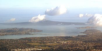
View of Hauraki Gulf with Motukorea at the right
|
|
| Geography | |
| Location | Hauraki Gulf |
| Coordinates | 36°49′50″S 174°53′41″E / 36.8306°S 174.8948°E |
| Highest elevation | 68 m (223 ft) |
| Administration | |
|
New Zealand
|
|
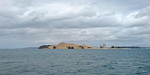
Motukorea, also known as Browns Island, is a small island in New Zealand. It is located in the Hauraki Gulf, just north of Musick Point. This island is one of the best-preserved volcanoes in the Auckland volcanic field.
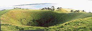
Scientists don't know exactly when the volcano erupted. Over many years, people used the island for farming. This means most of the original native plants are gone. You can easily see the different shapes of the volcano. The island shows three types of volcanic eruptions. It has a main scoria cone (a hill made of rocky bits). There is also a deep crater (bowl-shaped hole) at its top. Part of a tuff ring (a low, flat ring of volcanic ash) forms cliffs on the northeast side. You can also see parts of lava flows. When the volcano erupted, the area was dry land. Now, much of the old lava is under the sea.
Contents
Island History
Early Māori Life on Motukorea
The history of Motukorea before Europeans arrived is not fully known. However, it is clear that Ngāti Tamaterā Māori people lived there. They had the right to sell the island in 1840. Old stories say the Tainui canoe stopped at the island. This was after leaving Wakatiwai and before going to Rangitoto Island.
Later, the Ngāti Paoa people controlled the general area. The Ngāti Whātua people controlled lands to the west. But Motukorea remained under Ngāti Tamaterā control. Historians have different ideas why this was. Some think it was given for help in battles. Others believe it shows how different Hauraki tribes used the inner Gulf.
Motukorea was very important because it was at the mouth of the Tamaki River. This meant it controlled who could travel up the river. It also controlled access to the Ōtāhuhu and Karetu portages. These portages were paths to carry canoes between the Tamaki River and the Manukau Harbour.
Archaeological finds show that Motukorea was used a lot before Europeans came. People worked with stone and gathered food from the sea. They also gardened in the rich volcanic soil. They built both open and protected settlements. Three pā (fortified villages) sites have been found on the island. Old tools, like those made from moa bone, were found. Fishhooks made from one piece of bone were also found. Stones like chert, basalt, argillite, and obsidian were brought from other places. These places include nearby islands and as far as Coromandel Peninsula and Great Barrier Island. The name Motukorea means "oystercatcher island" in Māori.
European Settlers: Brown and Campbell
From 1820, early European visitors came to Motukorea. These included Richard Cruise, Samuel Marsden, and John Butler. They traded goods with Māori people. Jules Dumont d'Urville visited in 1827. He said the island was empty, probably because of the musket wars.
Since the island was empty and far from where Ngāti Tamaterā lived, they were willing to sell it. On May 22, 1840, Te Kanini of Ngāti Tamaterā and chiefs Katikati and Ngatai sold Motukorea. They sold it to William Brown and Logan Campbell. Brown and Campbell moved to the western side of the island on August 13, 1840. This made it one of the first European settlements in the Auckland area. They built a house from raupo (a type of reed). They also raised pigs on the island. They hoped to use it as a base to supply the new town of Auckland.
Soon after, the Ngāti Whātua chief Āpihai Te Kawau gave the island to Captain Hobson. He wanted Hobson to choose Auckland as the new capital. A flagpole was to be put on the island's highest point to claim it for the Crown. But Brown and Campbell heard about this. They quickly returned to the island and said they had the right to be there. So, the plan was stopped. Governor Hobson refused Brown's request for official ownership in August 1840. He said their purchase was made after a rule that stopped direct land purchases from Māori.
Things changed when Robert FitzRoy became governor in 1843. Brown and Campbell officially received the land on October 22, 1844. Campbell left the island in December 1840 to start a trading business in Auckland. Brown stayed until February of the next year. He managed the pig farm and looked after their interest in the island. In 1856, both men left New Zealand for Great Britain. They hired someone to manage their affairs. Campbell eventually bought Brown's share of their business, including Motukorea, in May 1873. He paid £40,000 for it. In 1877, Campbell wanted to plant olive trees on Motukorea. About 5000 young trees were grown for this, but they were never planted on the island. Campbell sold the island to the Featherstone family in 1879. They built a bigger house on the northeast side. This house burned down in 1915. The ruined house was still on the island until the 1960s.
Later Owners and Public Use
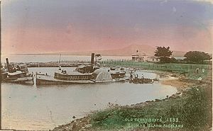
In 1906, the Alison family bought the island. They owned the Devonport Steam Ferry Company. During their time, four old coal-powered paddle steamers were left on the western end of the island. Browns Island is also important in aviation history. In June 1909, the Barnard brothers from Auckland flew gliders from the upper slopes of the cone. These might have been New Zealand's first glider flights. In the 1920s, the Devonport Steam Ferry Company often brought picnickers to the island. They landed at a long wooden wharf on the north side. A 1922 map shows a cottage on the northwest flat. This was likely built to replace the one that burned down in 1915.
The Auckland Metropolitan Drainage Board bought the island in 1946. They planned to build a sewage treatment plant there. But many people disagreed with this idea, so the plan was dropped. Sir Ernest Davis bought the island in 1955. He then gave it as a gift to the people of Auckland. Ernest Davis had been the head of the Devonport Steam Ferry Company for 20 years. This might explain why he liked Browns Island so much.
The Auckland City Council managed the island until 1968. Then it became part of the Hauraki Gulf Maritime Park. The Department of Lands and Survey managed it next. In 1987, this changed to the Department of Conservation. After the Hauraki Gulf Maritime Park Board ended in 1990, the Auckland City Council managed it again. They then passed the management back to the Department of Conservation.
In November 2018, a woman got stuck on the island. She was rescued after a fire she lit to get attention started to burn out of control.
Island Features
Browns Island is part of the Hauraki Gulf Maritime Park. There are three pā (old Māori fortified villages) sites on the island. The biggest one is on the slopes of the main scoria cone. The highest point of the island is 68 meters (223 feet) above sea level.
A special mineral called motukoreaite was found on the island in 1977. It was named after the island.
How to Visit
There are no regular ferries to Browns Island. So, you can only get there by private boat or seaplane.
There is no big wharf or easy landing spot for large boats. For small boats, the best place to land is on the northern side. This side is more sheltered. There is a 100-meter (328-foot) long beach there. Behind the beach is a steep cliff. It can be tricky to navigate because there is a 70-meter (230-foot) long rock reef parallel to the beach. A beacon marks this reef. Inside the reef, there are small rocks. But there is enough water for a small boat (up to 6 meters or 20 feet long) to move around. Someone should stand at the front of the boat to guide the driver.
To get to the rest of the island, you need to use a steep, rough path. This path goes up a small headland at the north end of the beach. It is only suitable for people who are fit and agile. The flatter areas to the west have very large mussel beds. These beds are partly underwater and stretch out 100 meters (328 feet) from the shore. This makes it hard to land there.
The closest places on the mainland to launch a boat are Bucklands Beach or Half Moon Bay Marina.
 | George Robert Carruthers |
 | Patricia Bath |
 | Jan Ernst Matzeliger |
 | Alexander Miles |


