Tamaki River facts for kids
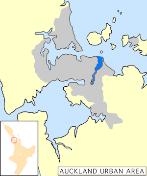
The Tāmaki River is a special kind of waterway in Auckland, New Zealand. It's mostly an estuary, which means it's where the ocean meets a river. This part of the Hauraki Gulf stretches south for about 15 kilometres (9.3 miles). It starts between the areas of Saint Heliers and Bucklands Beach, near a spot called Musick Point.
Along its sides, you'll find many suburbs. On the west side are places like Glendowie, Wai o Taiki Bay, Point England, Glen Innes, Tāmaki, Panmure, and Ōtāhuhu. On the east side, there's Bucklands Beach, Half Moon Bay, Farm Cove, Sunnyhills, and Pakūranga.
The Tāmaki River also has smaller arms, like branches of a tree. These include the Pakūranga Creek and Ōtara Creek on the east, and the Ōtāhuhu Creek and Panmure Basin on the west. The Ōtāhuhu Creek is very interesting because it's close to the narrowest part of the Auckland land strip, called an isthmus. Here, it's only about 1.25 kilometres (0.75 miles) to the Manukau Harbour, which is part of the Tasman Sea.
The river was originally called Te Wai o Taiki. This means "The Waters of Taiki." Taiki is a shorter version of Taikehu, who was an important ancestor of the Ngāi Tai people.
Contents
River History
Ancient Travel Routes
Long ago, before roads and cars, people used the Tāmaki River for travel. Portage Road is a famous spot where Māori people would move their waka (canoes) from one side of the land to the other. This was called a portage. By dragging their canoes overland, they could avoid paddling all the way around North Cape.
There was another portage called Kāretu. It connected the very north-east part of the Manukau Harbour to a bay near where a new bridge crosses the Tāmaki today. These portage routes were super important. They made the area a key place for travel and trade, both before Europeans arrived and in the early days of European settlement.
Early Bridges
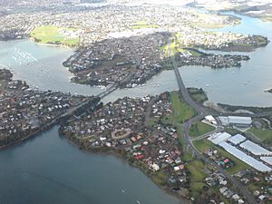
In 1865, the Tāmaki River got its first bridge. It was a steel swing bridge built in Panmure. This bridge helped connect Auckland with Howick. It was built about 20 metres (66 feet) to the left of the Panmure bridge you can see in the photo. The round base that allowed the bridge to swing open was only removed in the 1980s.
Explosives Ship Incident
In the 1890s, the mouth of the river was a safe place for ships carrying explosives to anchor. One time, a ship with explosives caught fire and exploded. Sadly, some people lost their lives. After this, the special buoy for explosives was moved to a more open area east of Browns Island (Motukōrea). It's still there today, marking a safer spot.
The Leopard in the River
Here's a wild story! In 1925, a leopard escaped from the Auckland Zoo. Three weeks later, a fishing group found it dead in the Tāmaki River, near Karaka Bay. It was about 1.8 metres (6 feet) long!
Getting Around the River
Crossing the Tāmaki
The Tāmaki River stretches from north to south and sits between Auckland City and Manukau City. This makes it a natural barrier for traffic. Only three bridges cross the river, and they get very busy, especially during rush hour. To help with this traffic, a big project called the Eastern Busway is being built. It aims to make it easier for people to travel across the river.
Boats and Ferries
The Tāmaki River is also important for boats. There's a marina and ferry wharf at Half Moon Bay. From here, you can catch ferries to Auckland CBD (the city centre) or car and passenger ferries to Waiheke Island. Many yachts are also kept here because the river offers good protection from the open sea.
The main path for boats in the river is marked by large green buoys. If you're on a big boat, it's important to stay close to these buoys. The channel is about 20 metres (66 feet) deep on average, but it can be quite narrow in some places. Near the big sand spit at Point England, there are many muddy areas that are barely covered by water when the tide is high.
For safety, the speed limit in the river is 10 kilometres per hour (5.4 knots). At the western entrance of the river, near St Heliers, there are rocks marked by a distinctive barber's pole. If your boat needs more than 4 metres (13 feet) of water, you should not try to go between Musick Point and Browns Island. The channel there is marked by special buoys about 20 metres (66 feet) apart. It's about 0.5 kilometres (0.3 miles) northwest of Musick Point. Also, watch out for large mussel beds that stretch out about 200 metres (660 feet) from Browns Island into the river.
 | Dorothy Vaughan |
 | Charles Henry Turner |
 | Hildrus Poindexter |
 | Henry Cecil McBay |


