Bucklands Beach facts for kids
Quick facts for kids
Bucklands Beach
|
|
|---|---|
|
Suburb
|
|
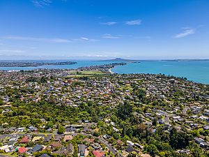
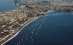
Aerial view looking along the Bucklands Beach peninsula
|
|
| Country | New Zealand |
| Local authority | Auckland |
| Electoral ward | Howick ward |
| Local board | Howick Local Board |
| Area | |
| • Land | 308 ha (761 acre) |
| Population
(June 2023)
|
|
| • Total | 9,360 |
|
|
||
Bucklands Beach is a cool suburb located about 13 kilometers east of Auckland's city center in New Zealand. It's part of the Howick area, which is one of the main parts of the Auckland Council region.
Contents
Exploring Bucklands Beach Geography
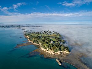
Bucklands Beach sits on the western side of a long piece of land, like a finger pointing out. This land is between the Tāmaki River and the Hauraki Gulf. At the very tip of this land is Musick Point / Te Naupata. The beach itself faces west, looking out towards a sandbar called Tahuna Torea on the other side of the Tāmaki River.
A Glimpse into Bucklands Beach History
Māori History and Early Life
The Bucklands Beach area has a rich history with the Ngāi Tai ki Tāmaki people. They are descendants of the Tainui canoe crew, who arrived around the year 1300. The mouth of the Tāmaki River was known as Te Wai ō Tāiki, named after an ancestor.
The traditional name for Bucklands Beach is Te Kōmiti. This area was very important because it was close to the Tāmaki Strait and a route called Te Tō Waka. This was a place where canoes could easily be moved across land to reach the Manukau Harbour.
Te Kōmiti was also a place where Tāmaki Māori made stone tools called adzes. They used special rocks found on Motutapu Island. The whole area was full of food, and the eastern side of the Tāmaki River was used for farming.
Around the 1700s, a Ngāi Tai chief named Ngāriki built a strong fort, or pā, at Te Naupata (Musick Point). It was called Te Waiārohia. This name means it had amazing views of the whole area.
During the Musket Wars in the 1820s, people left Te Waiārohia and the Bucklands Beach area for safety. The land became sacred to Ngāi Tai because of the fighting. Many Ngāi Tai people went to the Waikato region for a while. When a missionary visited in 1833, the area was mostly empty.
European Settlement and Growth
In 1847, Howick was set up as a military outpost. In 1851, William Mason bought land at Bucklands Beach and started a farm. At that time, the area was known as Tamaki Landing. It was a key transport spot, with a ferry connecting it to Panmure.
In 1861, William Mason sold his farm to Alfred Buckland, a big farmer in Auckland. The Buckland family loved to holiday at the beach. In 1865, they built a wharf for their animals. From the 1860s to 1879, a brick factory operated nearby.
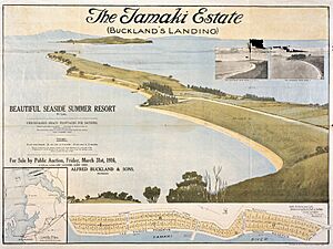
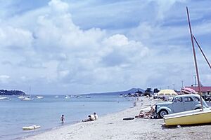
In the 1910s, Bucklands Beach became a popular holiday spot for people from Auckland. The Buckland farm was divided into smaller sections in 1916. A new wharf was built for passenger ferries. The first post office opened in 1921.
During World War II, a local defense group was formed. In 1942, an important radio station was built at Musick Point. It helped communicate with ships and planes. In 1949, the suburb's name officially changed from Buckland's Beach to Bucklands Beach.
The area stayed a holiday destination until the 1950s. After Howick became a borough in 1952, Bucklands Beach grew quickly. In 1954, the golf course moved to Musick Point. In 1956, the Buckland and Eastern Beaches War Memorial Community Centre opened.
Bucklands Beach Population
Bucklands Beach covers about 3.08 square kilometers. As of June 2023, it has an estimated population of 9360 people. This means there are about 3039 people per square kilometer.
The population has grown steadily. In 2018, there were 9,042 people living here. This was an increase from 8,817 people in 2013 and 8,598 people in 2006.
Many different cultures make up Bucklands Beach. In 2018, about 51.1% of people were European/Pākehā. About 3.3% were Māori, and 2.2% were Pacific peoples. A large group, 45.3%, were Asian. About 55.2% of the people living in Bucklands Beach were born outside of New Zealand.
Places to Visit and Things to Do
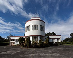
- Musick Point / Te Naupata: This area is home to the Musick Memorial Radio Station. It also has the Howick Golf Club, where you can play golf.
- Boating and Life Saving Club: The old clubrooms and boat ramp were built in 1968. The yacht club later moved to Half Moon Bay in 1982.
- Warren Boardwalk: This is a walking path built in 2011. It connects Half Moon Bay and Little Bucklands Beach. It's part of a longer path along the peninsula.
- Rogers Park: A public park with fields for football and American football. The local football club built its clubrooms here in 1984.
- Bucklands Beach Bowling Club: This club for lawn bowling was started in 1929.
- Reformed Presbyterian Church: This church opened its doors in 1955.
Schools in Bucklands Beach
Bucklands Beach has several schools for different age groups.
- Bucklands Beach Primary School: This was the first school here, opening in 1955.
- Macleans Primary School and Pigeon Mountain School: These are also primary schools for younger students (Years 1-6).
- Bucklands Beach Intermediate School: This school opened in 1976 for students in Years 7-8.
- Macleans College: This is a secondary school for older students (Years 9-13). It was established in 1980.
All these schools welcome both boys and girls. The number of students in each school changes, but they are all important parts of the community.
 | Aurelia Browder |
 | Nannie Helen Burroughs |
 | Michelle Alexander |


