Motutapu Island facts for kids
|
Native name:
Motutapu (Māori)
|
|
|---|---|

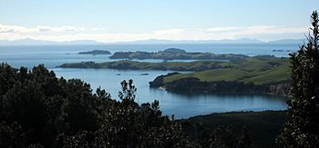
The nearest two headlands in this view from Rangitoto are part of Motutapu
|
|

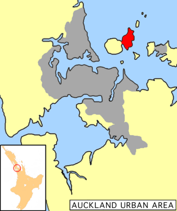
Location of Motutapu island (marked in red)
|
|
| Geography | |
| Location | Hauraki Gulf |
| Coordinates | 36°45′S 174°55′E / 36.750°S 174.917°E |
| Area | 15.1 km2 (5.8 sq mi) |
| Administration | |
| Demographics | |
| Population | 6 |
Motutapu Island is a 1,510-hectare island in the Hauraki Gulf. It is located northeast of Auckland, New Zealand. This special island is part of the Hauraki Gulf Maritime Park. You can visit Motutapu by taking a ferry from Auckland City.
Contents
What's in a Name?
The full Māori name for Motutapu is Te Motutapu a Taikehu. This means "The sacred island of Taikehu." Taikehu was a tohunga, or tribal priest, from the Tainui tribe. The word Motutapu means 'sacred' or 'sanctuary' island. This name is used for many islands in Polynesian areas.
Island Geography
About 18,000 years ago, during the Last Glacial Maximum, sea levels were much lower. Motutapu Island was actually connected to the North Island. A huge flat plain existed where the Hauraki Gulf is today. Around 7,000 years ago, sea levels rose. This made Motutapu an island, separate from the rest of New Zealand.
Today, the island is connected to Rangitoto Island by a man-made causeway. Rangitoto is a much younger volcanic island. Before Rangitoto's volcano erupted, Māori people lived on Motutapu for over 100 years. The eruption happened about 700 years ago. It destroyed their homes. Some people might have escaped by waka (canoe). One special place, called the Sunde Site, has human and dog footprints. These footprints were saved in hardened ash from the eruption.
Motutapu Island does not have many forests like Rangitoto. Most of the land is covered in grass and wet meadows. There are not many large trees. However, the Motutapu Restoration Trust is working to plant many native trees and plants.
In March 2013, two small earthquakes happened under Motutapu Island. They measured 3.1 and 3.9. People worried they might mean Rangitoto volcano would erupt. But geologists said the earthquakes were from fault lines, not volcanic activity.
Island History
Motutapu was one of the first places where people lived in the Auckland area. This includes both Polynesians and later, Europeans. The earliest signs of people living on Motutapu are from before the Rangitoto eruption, around 1400 AD. The eruption covered Motutapu in ash. This destroyed many forests. But the ash also made the soil good for gardening.
Archaeologists found that after the eruption, people changed how they lived. They started to focus more on fishing and growing crops. Many kumara pits were found. Between 1400 and 1500 AD, people also made adze (toki) tools on the island. They used the greywacke rock found there.
After the eruption, the Arawa and Tainui canoes are said to have visited Motutapu. The Tainui ancestors of the Ngāi Tai ki Tāmaki then settled there. The island's traditional name, Te Motu Tapu a Taikehu, refers to a tohunga from the Tainui canoe. The Ngāi Tai people lived on Motutapu for a long time.
In the 1820s, many islands in the Hauraki Gulf were left empty. This was because of the threat from Hongi Hika and the Ngāpuhi tribe, who had muskets. Many Hauraki tribes went south. The Ngāi Tai found safety at Maungatautari. From 1836, many of the empty areas were settled again. The Ngāi Tai stayed on Motutapu until 1840. That year, the northern part of the island was sold to Tom Maxwell. Since the 1840s, the island has been used as a farm. Farming settlements were set up at Emu Bay and Home Bay.
Maxwell was married to Ngeungeu, the daughter of a main chief. From 1840 to 1845, the northern part of the island was rented out. The southern part was bought in 1845. Later, it was given to politician Robert Graham in 1857. Motutapu became a popular place for trips. Home Bay Wharf had fun activities like whale boat racing and hunting. The Reid brothers bought the island in 1869–70. They owned it until 1943. Several farmhouses were built at Home Bay. The current Reid Homestead was built in 1901–03.
Work began on the Motutapu counter-bombardment battery in 1936. This was a military defense site. By 1937, the battery and observation post were finished. Guns were put in place by 1938. When World War II started in 1939, the number of soldiers on the island grew from 10 to 200. More buildings were needed. The US Navy planned to use Auckland as a base. This led to building deepwater wharves and 50 ammunition magazines between 1942 and 1943. The war ended in 1945. Within five years, the entire military site was left empty.
The Department of Conservation started a long-term project on the island in 1992. Their goal is to replant the island with native plants by the 2040s.
Island Landscape
Motutapu Island is made of different types of rock. It has greywacke, chert, and argillite rocks. These are covered by younger sediments and ash from Rangitoto. The island has many archaeological sites. These include old campsites from before the Rangitoto eruption. There are also sites where tools were made. You can find 13 pā (fortified villages), many open settlements, and areas for farming. There are 372 recorded sites, and many more are likely hidden underground.
The size of these sites changes over time. Settlement sites are found all over the island. Some are grouped on the western side, near streams. Early settlements were often near stream mouths. This might mean people used a system of rotating gardens. Pā sites are on most defendable coastal areas. However, the small size of these fortified areas suggests that Motutapu was mostly a peaceful farming community. Forts were built only when there was a threat.
People used local rocks like greywacke for tools. They also used obsidian from Great Barrier and Northland. Other rocks like jasper and sandstone were used for hammerstones and grinders.
There are three main areas linked to 19th-century farming. Home Bay still has a farmhouse, plants, a seawall, and graves. Emu Bay has the foundations of old buildings and some Norfolk pines. No old farm remains have been found yet at Station Bay.
The military structures on Motutapu are still mostly there from World War II. This includes the main gun area with three gun pits and underground storage. There are also observation posts, engine rooms, and plotting rooms. Searchlights were placed at Billy Goat point. Soldier camps were at Administration Bay. The US Navy had ammunition magazines north of the causeway. Many small concrete bunkers, called pillboxes, were built to protect the battery. The island also has old roads, wharves, and quarries from that time.
Restoring Nature
By the mid-1800s, almost all the natural plants on Motutapu were gone. This was due to the volcanic eruption and later, farming. Also, pests were brought to the island by both Māori and Europeans.
Removing Pests and Bringing Back Native Animals
Animals like possums and wallabies were removed from the island in the early 1990s. In 2009, poison baits were dropped by air on Motutapu and Rangitoto. By 2010, rats, rabbits, and stoats seemed to be gone. Most cats were removed, and hedgehogs were still common. In August 2011, both Rangitoto and Motutapu were declared free of pests.
Since then, many native New Zealand animals have been brought to Motutapu. These include takahē, saddleback, and North Island brown kiwi. The Motutapu Restoration Trust leads this work. They are restoring both the natural environment and the island's history. This includes fixing up the historic Reid homestead, replanting forests, and restoring wetlands.
Farming for a Healthier Island
Since the mid-1990s, Motutapu Farms Limited has been using 'regenerative farming' methods. This is also called 'biological' farming in New Zealand. It means farming in a way that helps the soil and nature.
Professor Norman Uphoff from Cornell University says that this type of farming is very modern. It uses science, especially biology, ecology, and microbiology, to build healthy systems.
Regenerative farming is becoming more popular. Farmers are responding to social and environmental needs. A 2011 UN report looked at 286 sustainable farming projects. It found that this approach is stronger against extreme weather. It also greatly reduces the need for oil-based pesticides and fertilizers. The report also showed that using soil health methods increased food production by 150%. This matches what New Zealand farmers have seen on their own land.
See also
 In Spanish: Motutapu para niños
 | George Robert Carruthers |
 | Patricia Bath |
 | Jan Ernst Matzeliger |
 | Alexander Miles |


