
Pakuranga facts for kids
Quick facts for kids
Pakuranga
|
|
|---|---|
|
Suburb
|
|
.jpg)
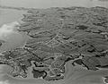
Pakuranga, looking east (the suburb is the "peninsula"-shape on the far side of the Tamaki River)
|
|

Pakuranga
Location in New Zealand
|
|
| Country | New Zealand |
| Local authority | Auckland |
| Electoral ward | Howick ward |
| Local board | Howick Local Board |
| Area | |
| • Land | 342 ha (845 acre) |
| Population
(June 2023)
|
|
| • Total | 9,810 |
|
|
||
Pakuranga is a suburb in eastern Auckland, New Zealand. It sits on low hills and flat areas that used to be swamps. These lands are now drained. Pakuranga is located between the Pakuranga Creek and the Tamaki River. Both are arms of the Hauraki Gulf. It is about 15 kilometres southeast of Auckland CBD, which is the city centre.
Contents
Exploring Pakuranga's Location and Environment
Pakuranga is found on the eastern side of the Tāmaki River. It's like a small land area (a peninsula) between the river and the Pakuranga Creek to the south. A long time ago, in the 1800s, the inner parts of Pakuranga were wet, swampy areas. These swamps were full of Cordyline australis, also known as cabbage trees.
Understanding Pakuranga's Weather
Pakuranga has a mild climate. The warmest month is usually February, with average high temperatures around 25°C. The coolest month is July, with average high temperatures around 16°C. It rarely gets very cold, with the lowest recorded temperature being -3.3°C in June.
The Story Behind the Name Pakuranga
The name Pakuranga comes from the Māori phrase Te Pakuranga-rāhīhī. This means "The Battle of the Sun's Rays." It's part of an old Tāmaki Māori story. This story tells of a battle between magical people called Tūrehu. They used magic to turn warriors into stone using the sun's rays. The gods Mataaho and Rūaumoko were so angry about this battle that they created the Auckland volcanic field. The name Pakuranga was also used for Ōhuiarangi / Pigeon Mountain, a volcano nearby.
Early European settlers started using the name Pakuranga in the 1840s. It referred to the area between the Tāmaki River and Tūranga Creek. After the town of Howick was set up, Pakuranga meant the countryside west of Howick. The modern area of Pakuranga was officially named in 1956.
A Glimpse into Pakuranga's Past
Māori Heritage and Early Settlements

The Pakuranga area is the traditional home of Ngāi Tai ki Tāmaki. These people are descendants of the Tainui canoe crew, who arrived around the year 1300. The mouth of the Tāmaki River was known as Te Wai ō Tāiki. This name honours the Ngāi Tai ancestor Tāiki. Tāiki and his people settled along the eastern shores of the Tāmaki River.
The upper part of the river near Pakuranga was called Te Wai Mokoia. This refers to Mokoikahikuwaru, a special taniwha (water spirit) from the Tainui canoe stories. This taniwha was said to live in the Panmure Basin.
Ngāi Tai people grew many crops along the Tāmaki River's eastern shores. Ōhuiarangi / Pigeon Mountain was a very important fortified village (pā) for Ngāi Tai ki Tāmaki. It was named after an ancestress, Huiārangi. The slopes of the mountain were used for stonefield gardens. People also caught kererū (native pigeons) there. Around the 1700s, a Ngāi Tai leader named Ngāriki built a fortified pā called Te Waiārohia at Te Naupata (Musick Point).
By the mid-1700s, Ngāti Pāoa, a tribe from the Hauraki Gulf, settled on the western side of the river in Panmure. They had a pā called Mokoia and a village (kāinga) called Mauināina. When missionaries visited in 1820, thousands of people lived along the Tāmaki River at Mokoia.
During the Musket Wars in the 1820s, Mokoia pā and Mauināina were attacked. Many people left the area, with Ngāi Tai members going to the Waikato for safety. By 1833, the area was mostly empty. The land at Mokoia and Mauināina pā became tapu (sacred) for Ngāti Pāoa because so many people had died there.
In 1836, a missionary named William Thomas Fairburn arranged a land sale. This sale covered much of modern-day South Auckland, East Auckland, and the Pōhutukawa Coast. The idea was to stop conflicts, but it's not clear if the Māori chiefs fully understood or agreed. Māori continued to live on the land. In 1854, a special reserve was created for Ngāi Tai near the Wairoa River. As part of this, Ngāi Tai people agreed to leave their traditional homes to the west.
European Settlers Arrive

The Pakuranga area was sold by the government in 1843. Many people started farms there. One of the first European houses was built in 1843 by Joseph Hargreaves. In 1847, Howick was set up as a military outpost for Auckland. Retired British soldiers and their families lived there. Ferry services across the river to Panmure began in 1850. Many early farmers in Pakuranga were soldiers from Howick. By the mid-1860s, wheat was the main crop.
In September 1863, during the Invasion of the Waikato, a Ngāi Tai village was attacked. The villagers moved to communities closer to the river's mouth. While some Māori were forced to leave, Ngāi Tai were considered "friendly" by the Crown and stayed neutral in the fighting. After 1865, much of the Ngāi Tai land was taken by the government. The remaining land was divided and slowly sold to European farmers.
Pakuranga became easier to reach after the Panmure Bridge opened in 1865. This bridge connected Pakuranga to Panmure across the Tāmaki River. In the same year, the capital of New Zealand moved from Auckland to Wellington. This caused money problems for the area. Land prices dropped, and the demand for butter decreased. In 1869, Alfred, Duke of Saxe-Coburg and Gotha (the Duke of Edinburgh) visited New Zealand. He spent a month living in Pakuranga.
In 1874, the Pakuranga Hunt was started. By 1900, it was one of Auckland's biggest social clubs. The Hunt was based in East Tāmaki. They organized hare hunts and county balls. The name Pakuranga became strongly linked to the hunt. By 1960, the hunt had moved south to Karaka.
By the late 1800s, Pakuranga looked like the English countryside. It had many poplar, oak, and willow trees. Over time, dairy farms replaced the wheat fields. These farms were common until the 1940s. The Pakuranga Hall opened in 1921.
Growing into a Suburb


In the 1930s, the road to Howick was paved with concrete. This made it faster to transport milk to Auckland and for people to travel. In 1948, Pakuranga was considered for a new international airport. However, the airport was eventually built in Māngere. From the 1950s, land in Pakuranga was divided into sections for houses. The local council wanted to keep a green area between Pakuranga and Howick. But they lost a court case to a farmer who wanted to divide his land. By 1956, Pakuranga had grown enough to become a County Town. A new Panmure Bridge was built in 1959, helping the area grow even more.
In 1965, the Pakuranga Town Centre, now known as Pakuranga Plaza, officially opened. It was Auckland's second modern American-style shopping mall. It had big stores like Farmers. By the mid-1970s, Pakuranga became known as a place for busy housewives. It even got nicknames like "Nappy Valley" and "Vim Valley." The second name came from a popular advertisement for a cleaning product called Vim, which featured housewives from Pakuranga.
The Pakuranga Community Hall opened in 1975. In 1981, Lloyd Elsmore Park officially opened. This is a large park with sports facilities. It is also home to the Howick Historical Village.
The Eastern Busway project started in 2019. This project aims to connect Botany to Panmure with fast bus transport. The busway opened to Pakuranga in 2021. The whole project is expected to be finished by the mid-2020s.
People and Population in Pakuranga
Pakuranga covers about 3.42 square kilometres. It has an estimated population of 15,300 people as of 2023. This means there are about 4,474 people living in each square kilometre.
In 2018, Pakuranga had a population of 7,689 people. This was an increase of 444 people since 2013. There were 2,418 households. The population included 3,798 males and 3,888 females. About 19.8% of the people were under 15 years old.
People in Pakuranga come from many different backgrounds. In 2018, about 44.4% were European/Pākehā. About 11.7% were Māori. Around 13.2% were Pacific peoples. A large group, 41.4%, were Asian. About 48.0% of people in Pakuranga were born overseas. This is higher than the national average of 27.1%.
Many people in Pakuranga have no religion (40.9%). About 37.2% are Christian. Other religions include Hindu (6.3%), Muslim (3.4%), and Buddhist (3.3%).
About 24.2% of people aged 15 or older had a university degree or higher. About 16.1% had no formal qualifications. Many people work full-time (52.3%) or part-time (12.5%).
Interesting Places to Visit in Pakuranga
- Pakuranga Plaza was built in 1965. It's a major shopping centre.
- Howick Historical Village is a place where you can see what a European settler village looked like in the 1800s. It opened in 1997.
- Te Tuhi (formerly Te Tuhi Centre for the Arts) is an art gallery that opened in 1975.
- Bell House was built in 1851. It was moved to Lloyd Elsmore Park in 1895. In 1973, it was given to the Historic Places Trust to protect it.
Schools in Pakuranga
Before the 1960s, there were no schools in Pakuranga. Children had to walk or ride horses to the old Howick school. This old school was later moved to the historical village display in Bells Road, Pakuranga.
Pakuranga has several schools:
- Edgewater College is a secondary school for students in years 9–13.
- Pakuranga Intermediate is for students in years 7–8.
- Anchorage Park School and Riverina School are primary schools for years 1–6.
- Saint Kentigern College is a private Presbyterian secondary school for years 7–13.
All these schools teach both boys and girls.
Images for kids
-

Pakuranga is located on the eastern shores of the Tāmaki River.
-
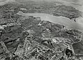
Aerial view of Pakuranga in 1961, when the area was predominantly farmland.
-
Aerial view of Pakuranga in 1969, during the widespread construction of suburban housing developments.

