East Auckland facts for kids
Quick facts for kids
East Auckland
|
|
|---|---|
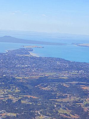
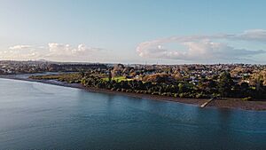
An aerial view of some of the suburbs traditionally considered East Auckland, including Bucklands Beach, Howick and Botany Downs.
|
|
| Country | New Zealand |
| Island | North Island |
| Region | Auckland Region |
| NZ Parliament | Botany Pakuranga |
| Area | |
| • Total | 69.70 km2 (26.91 sq mi) |
| Population
(2023 estimation)
|
|
| • Total | 157,700 |
| • Density | 2,262.6/km2 (5,860.0/sq mi) |
East Auckland (also known as Māori: Te Rāwhiti o Tāmaki Makaurau in Māori) is a large area within Auckland, which is the biggest city in New Zealand. People first settled here in the 1300s. It is the traditional home of the Ngāi Tai ki Tāmaki people.
In the 1840s, the area became farmland. The town of Howick was set up as a military base. It was built by fencibles, who were retired British Army soldiers. Their job was to help protect Auckland.
From the 1910s, coastal areas became popular holiday spots. Then, from the 1950s, East Auckland grew into a big suburban area. Since the 1980s, many Asian New Zealander families have moved to live here.
Contents
What is East Auckland?
Defining the Area
Most people agree that East Auckland includes the Howick local board area. This area has suburbs like Botany, Bucklands Beach, Howick, Flat Bush, and Pakuranga.
Sometimes, other areas are also called East Auckland. These can be suburbs from the eastern Auckland isthmus, like Glen Innes and Panmure. The Pōhutukawa Coast is also sometimes included.
How the Name Came About
The name "East Auckland" first appeared in the 1970s. Back then, it mostly referred to Glen Innes. The name became popular for areas near Howick in the 1990s. In the 1800s, the area was sometimes called East Tāmaki.
Nature and Landscape
Rivers, Coasts, and Landforms
Much of East Auckland is a peninsula. It has the Tāmaki River to the west and the Tāmaki Strait (part of the Hauraki Gulf) to the east. The Mangemangeroa Creek is also on the eastern side. The peninsula ends in the north at a place called Musick Point / Te Naupata.
The land is mostly made of Waitemata sandstone. This rock formed a very long time ago, in the Early Miocene era. You can see interesting rock folds, called anticlines, at the cliffs of Eastern Beach. Many areas near the Tāmaki River and other creeks have rich, soft soils.
Volcanic Features
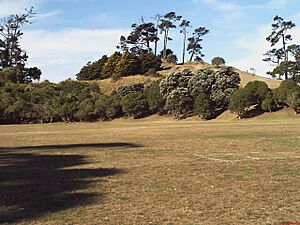
East Auckland also has features from the Auckland volcanic field. These include Ōhuiarangi / Pigeon Mountain, Ōtara Hill, and Green Hill. These volcanoes erupted between 57,000 and 20,000 years ago. Because of these eruptions, parts of Half Moon Bay and East Tāmaki are made of volcanic rock.
Ancient Forests and Modern Farms
The Tāmaki River is a "drowned river valley." This means it was a river valley that filled with sea water as sea levels rose. This happened after the last Ice Age, between 12,000 and 7,000 years ago.
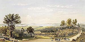
Before people arrived, East Auckland was covered in thick forests. These forests had trees like tōtara, mataī, and pōhutukawa. By the 1800s, much of the forest had been replaced by bracken fern plants. In the 1850s, the area was turned into English-style farmland. It became mostly pastures with trees like poplar and oak.
History of East Auckland
Māori History and Early Settlements
The Tainui waka (canoe) visited the Tāmaki Strait around the year 1300. Some of its crew settled in what is now East Auckland. These people were the ancestors of Ngāi Tai ki Tāmaki, who are the traditional people of this land.
The wider bay between Howick and Beachlands was known as Waipaparoa. The mouth of the Tāmaki River was called Te Wai ō Tāiki. This name means "The Waters of Tāiki," after a Ngāi Tai ancestor. The upper part of the river near Pakuranga was known as Te Wai Mokoia. This refers to Mokoikahikuwaru, a special taniwha (water spirit) from Tainui legends.
The settlements along the Tāmaki River were important. They were close to Te Tō Waka, a place where canoes could be carried across land to the Manukau Harbour. Many old trails in East Auckland might have started as moa trails.
Ngāi Tai people lived between the Tāmaki and Wairoa rivers. They moved around based on what food was available each season. They gathered fish, shellfish, and birds. They also grew crops like kūmara (sweet potato) and taro. The volcanic soils, especially near Ōtara Hill, were used for large gardens.
Ōhuiarangi / Pigeon Mountain was an important pā (fortified village) for Ngāi Tai ki Tāmaki. It was named after an ancestress, Huiārangi. Other pā sites, like Paparoa at Waipaparoa / Howick Beach, helped protect the gardens.
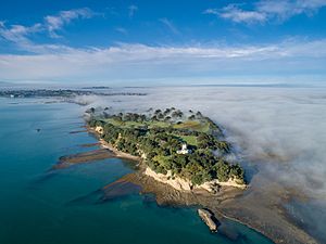
In the 1700s, Ngāriki, a leader of Ngāi Tai, built a strong pā at Musick Point, called Te Waiārohia. This became a major center for Ngāi Tai life. By the early 1800s, thousands of people lived along the Tāmaki River.
Arrival of Europeans and Changes
The first Europeans to regularly visit Māori in East Auckland were whalers in the late 1700s. These visits brought diseases like rewharewha (respiratory illness), which greatly reduced the Māori population.
During the Musket Wars in the 1820s, many Māori settlements were attacked. Ngāi Tai people had to leave their homes and seek safety in the Waikato region. When missionary William Thomas Fairburn visited in 1833, the area was mostly empty. Many old settlements became tapu (sacred and forbidden) because so many people had died there.
In 1836, Fairburn arranged a large land sale with Māori chiefs. This sale covered much of modern-day South and East Auckland. However, it's not clear if the chiefs fully understood or agreed to the sale. Māori continued to live on the land. Later, the New Zealand government reduced the size of Fairburn's purchase. Most of the land that was taken back was not returned to Ngāi Tai. Instead, the government kept it to sell to new settlers.
Early European Settlement and Howick's Beginnings
Fairburn started a mission at Maraetai in 1837. He taught reading, writing, and Christianity to Ngāi Tai and Ngāti Pāoa. This mission farm was one of the first farms in Auckland.
The town of Howick was founded in 1847. It was meant to be a defensive outpost for Auckland, settled by retired British soldiers called fencibles. The government owned all the land in Howick, so they could sell it directly to these settlers.
Early settlers found it hard to build homes and farm. There were almost no trees for building, and the soil was mostly clay. This was different from other fencible settlements that had better soil. Settlers often worked on government projects like building roads. They relied on boats for transport until the Panmure Bridge was built across the Tāmaki River in 1865.
In the 1860s, during the Invasion of the Waikato, a defensive fort was built at Stockade Hill. Ngāi Tai people were considered "friendly" by the government and stayed neutral in the fighting. However, after 1865, much of Ngāi Tai's land was taken by the government and sold to European farmers.
When Wellington became the capital of New Zealand in 1865, it caused money problems for Howick. Land prices dropped. In 1874, the Pakuranga Hunt was started. This became a very popular social club.
By the late 1800s and early 1900s, dairy farms replaced wheat fields. In the 1910s and 1920s, places like Bucklands Beach and Eastern Beach became popular holiday spots for people from Auckland. Holiday homes were built, and seasonal communities grew around these beaches.
Modern Suburban Growth
In the 1930s, the road to Howick was paved. This made it easier to transport milk to Auckland and for people to travel. Howick then became a "commuter suburb" for people working in other parts of Auckland. During World War II, defenses were built along the coast. In 1942, a Japanese submarine and plane were seen near Howick.
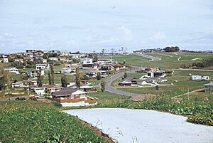
In 1952, Howick became its own borough (a type of town council). From the 1950s to the 1970s, East Auckland grew rapidly with many new suburbs. In 1965, the Pakuranga Town Centre (now Pakuranga Plaza) opened. It was one of the first modern American-style shopping malls in Auckland.
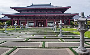
In the 1980s and 1990s, many Asian families moved to East Auckland. Business owner Kit Wong helped create shopping and restaurant areas in Meadowlands and Somerville. These places became important centers for Chinese New Zealander communities. In 2007, the Fo Guang Shan Temple, the largest Buddhist temple in New Zealand, opened in Flat Bush.
Lloyd Elsmore Park, a large park with sports facilities and the Howick Historical Village, opened in 1981. The Botany Town Centre shopping area opened in 2001.
In the 2000s, many new housing areas were built in the south, including Flat Bush and Dannemora. The Ormiston Town Centre opened in 2021. The Flat Bush area is expected to have 40,000 residents by 2025. The Eastern Busway, a project to connect Botany to Panmure with fast bus routes, started construction in 2019. The busway opened to Pakuranga in 2021.
Local Government
Road boards were the first local governments in the 1860s. They helped manage roads. Later, in 1876, the Manukau County was created to govern South and East Auckland.
Howick became a town district in 1921 and its own borough in 1952. In 1965, Howick and Pakuranga joined the new Manukau City. In 1989, Howick Borough became part of Manukau City.
In November 2010, all the cities and districts in the Auckland Region joined together to form one big council, the Auckland Council. Now, East Auckland is mainly managed by the Howick Local Board. People in the Howick ward also vote for two councillors to represent them on the Auckland Council.
People of East Auckland
Population and Diversity
The Howick ward in East Auckland covers about 69.70 square kilometers. As of 2023, it had an estimated population of 157,700 people.
In the 2023 census, the population was 153,570. This was an increase of 12,600 people since the 2018 census. The median age was 38.1 years. About 19.0% of the people were under 15 years old.
People in East Auckland come from many different backgrounds. The census showed that 38.1% identified as European (Pākehā), 6.3% as Māori, 8.0% as Pasifika, and 52.5% as Asian. Many people also identified with other ethnic groups.
English is spoken by most people (88.6%). Other languages are also widely spoken, with 43.3% speaking a language other than English, Māori, or Samoan.
Religion and Education
Many different religions are practiced in East Auckland. About 32.4% of people identified as Christian, 7.2% as Hindu, and 3.6% as Buddhist. A large number of people (42.6%) said they had no religion.
Education levels are high in the area. About 31.9% of people aged 15 or older had a bachelor's degree or higher. Many people also had other post-high school qualifications. The median income was $44,900.
 | Roy Wilkins |
 | John Lewis |
 | Linda Carol Brown |


