Eastern Beach, New Zealand facts for kids
Quick facts for kids
Eastern Beach
|
|
|---|---|
|
Suburb
|
|

Eastern Beach Aerial Photo
|
|
| Country | New Zealand |
| Local authority | Auckland |
| Electoral ward | Howick ward |
| Local board | Howick Local Board |
| Area | |
| • Land | 118 ha (292 acre) |
| Population
(June 2023)
|
|
| • Total | 2,140 |
|
|
||
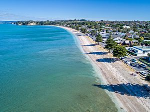
Eastern Beach is a suburb in Auckland, New Zealand. It's located on the eastern side of the city centre. This area is part of the Howick ward, which is one of Auckland City's main administrative areas. The most popular spot here is its beautiful white-sand beach, also called Eastern Beach. It has palm trees and attracts many people in summer. They come to enjoy the shallow water, and there are shops and parks nearby. At the southern end of the beach, there's a boat ramp. This ramp allows boats to access a special water skiing zone when the tide is high or medium. People used to gather shellfish like pipi and cockles here. However, due to too much collecting, there is now a rāhui (a ban or restriction) on the beach to protect them. Eastern Beach is part of the Bucklands Beach peninsula.
Contents
Eastern Beach Geography
Eastern Beach is found on the eastern side of a peninsula. A peninsula is a piece of land surrounded by water on three sides. This peninsula is located between the Tāmaki River and the Tāmaki Strait, which is part of the Hauraki Gulf. The beach faces out towards the Tāmaki Strait and Waiheke Island.
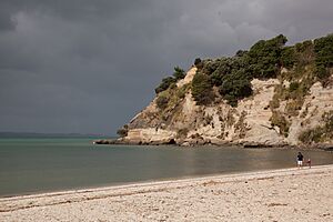
The land in this area is mostly made of a type of rock called Waitemata sandstone. If you look closely at the cliffs along the beach, you can see interesting folds in the layers of sandstone. These folds are called anticlines. Also, Macleans Reserve, a nearby park, has a large bed of fossilized shells. This area is known as a chenier plain.
Eastern Beach History
Eastern Beach is part of the traditional land, or rohe, of Ngāi Tai ki Tāmaki. These are Māori people who are descendants of the crew from the Tainui canoe. They visited this area around the year 1300. An early ancestor named Tāiki and his followers settled along the eastern shores of the Tāmaki River. They lived alongside the descendants of Huiārangi from the early iwi (tribe) Te Tini ō Maruiwi. The traditional Māori name for Eastern Beach is Okokino. The headland south of the beach was known as Ngataieura. Eastern Beach and the surrounding areas were important for Ngāi Tai's farming.
Early Settlements and Conflicts
Around the early 1700s, Ngāriki, a chief (rangatira) of Ngāi Tai, built a fortified village called a pā. This pā was at Te Naupata, also known as Musick Point. Its name was Te Waiārohia, meaning it had amazing views of the area. Ngāriki and the people of Te Waiārohia often had disagreements with Ngaromania. Ngaromania was another chief who lived across the Tāmaki River. He demanded high fees from anyone passing by. From the 1790s, Te Rangitāwhia was the main chief of Ngāi Tai. His main homes were at Waiārohia and further south at Ōhuiarangi / Pigeon Mountain.
During the Musket Wars in the 1820s, Te Waiārohia and the Eastern Beach area were left empty. The land became tapu (sacred or forbidden) to Ngāi Tai because of the events of the conflict. Most Ngāi Tai people went to the Waikato region for safety during this time. When an English missionary named William Thomas Fairburn visited in 1833, the area was mostly empty.
European Settlement and Development
In 1836, William Thomas Fairburn arranged a large land sale with Tāmaki Māori chiefs. This sale covered much of what is now South and East Auckland. The idea was to stop fighting in the area. However, it's not clear if the chiefs fully understood or agreed to the sale. Māori people continued to live in the area as before. In 1854, when Fairburn's purchase was looked into by the New Zealand Land Commission, a special reserve was created for Ngāi Tai. This reserve was around the Wairoa River and Umupuia areas. As part of this agreement, Ngāi Tai members agreed to leave their traditional settlements to the west.
In 1847, Howick was set up as a military outpost for Auckland. It was settled by fencibles, who were retired British Army soldiers, and their families. In 1851, William Mason bought a large piece of land from Fairburn. This land is where Bucklands Beach is today. Mason started a farm there, growing crops and raising goats. He built a two-story house above the beach, which was later taken down in the 1950s. This area became known as Mason's Beach until the late 1940s. In 1861, Mason sold his farm to Alfred Buckland, who was a very large farmer in Auckland. The Buckland family used to spend holidays at the beach. In 1865, they built a wharf for cattle and sheep. From 1880 to 1922, John Granger ran a lime factory at Eastern Beach. Here, local shells were crushed and burned to make lime.
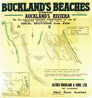
Eastern Beach and Bucklands Beach became popular holiday spots starting in the 1910s. The Buckland farm was divided into smaller sections for housing in 1916, creating Bucklands Beach. The Devonport Steamship Company built a second wharf at Bucklands Beach for passenger services. Around this time, phoenix palm trees were planted at Eastern Beach. This was done to give the area a tropical look. In 1923, Eastern Beach was also divided into sections for houses. By 1934, it became a regular spot for the Auckland Caravaning Club.
During World War II, local residents built concrete pillboxes (small defensive bunkers) on the clifftops at each end of Eastern Beach. After Howick became a borough (a type of town) in 1952, the area quickly grew with new suburban houses.
Eastern Beach Facilities
- Eastern Beach, which has a boat ramp for easy water access.
- Macleans Park, a large urban park and nature reserve.
- Willow Park Christian Camp, a big camping facility located in Eastern Beach.
Eastern Beach Population
Eastern Beach covers about 1.18 square kilometers. As of 2023, it had an estimated population of 2,200 people. This means there are about 1,864 people living per square kilometer.
Population Changes Over Time
- 2006: 2,181 people
- 2013: 2,136 people
- 2018: 2,190 people
At the 2018 New Zealand census, Eastern Beach had 2,190 residents. This was a small increase of 54 people (2.5%) since the 2013 census. There were 765 households. The population included 1,050 males and 1,140 females. The average age was 45.0 years. About 360 people (16.4%) were under 15 years old.
Ethnic Backgrounds
The people living in Eastern Beach come from various backgrounds:
Many people (48.5%) living in Eastern Beach were born overseas. This is higher than the national average of 27.1%.
Religious Beliefs
When asked about their religion, people in Eastern Beach shared:
- 49.9% had no religion
- 35.6% were Christian
- 0.3% had Māori religious beliefs
- 2.2% were Hindu
- 1.8% were Muslim
- 3.0% were Buddhist
- 2.9% had other religions
Education and Work
Of those aged 15 and older, 594 people (32.5%) had a bachelor's degree or higher. About 189 people (10.3%) had no formal qualifications. The average income was $35,100. Many people (44.6%) worked full-time, while 14.3% worked part-time. About 2.6% were unemployed.
| Historical population | ||
|---|---|---|
| Year | Pop. | ±% p.a. |
| 2006 | 2,181 | — |
| 2013 | 2,136 | −0.30% |
| 2018 | 2,190 | +0.50% |
 | Kyle Baker |
 | Joseph Yoakum |
 | Laura Wheeler Waring |
 | Henry Ossawa Tanner |


