Māngere facts for kids
Quick facts for kids
Māngere
|
|
|---|---|
|
Suburb
|
|
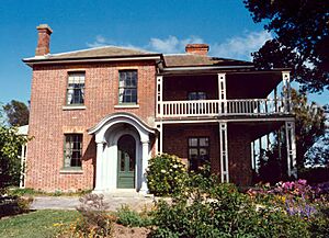
Massey Homestead, the former residence of William Massey prime minister of New Zealand and notable resident of Māngere
|
|
| Country | New Zealand |
| Local authority | Auckland |
| Electoral ward | Manukau ward |
| Local board | Māngere-Ōtāhuhu Local Board |
| Area | |
| • Land | 904 ha (2,234 acre) |
| Population
(June 2023)
|
|
| • Total | 24,060 |
| Postcode(s) |
2022
|
| Airport(s) | Auckland Airport |
|
|
||
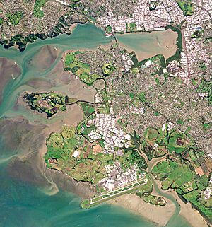
Māngere (Māori pronunciation: [ˈmaːŋɛɾɛ]) is a large suburb in South Auckland, New Zealand. It sits on flat land near the Manukau Harbour. It is about 15 kilometres south of Auckland city centre. Auckland Airport is located here, close to the harbour.
People from Tāmaki Māori groups have lived in Māngere for a very long time. They used to farm the land and build fortified villages called pā on places like Māngere Mountain. In the 1840s and 1850s, Te Ākitai Waiohua communities grew strong with a mission and large wheat farms. However, this changed in 1863 during the Invasion of the Waikato. Māngere stayed a rural area until the mid-1900s. Then, it became one of Auckland's biggest areas for state housing.
Contents
What's in a Name?
The name Māngere comes from the Māori language phrase "Ngā Hau Māngere". This means "the gentle breezes". Taikehu, a chief from the Tainui canoe, gave the area this name.
In the 1800s, the spelling of Māngere changed a lot. It was sometimes written as Mangere, Mangerei, or Mangare. After 1897, the spelling "Mangere" became more common. In 2019, the official name was changed to Māngere, with a line over the 'a' (called a macron).
The middle part of Māngere was once known as Taotaoroa. This name means "The Extensive Plains".
Where is Māngere?
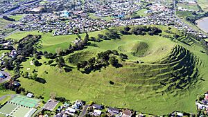
Māngere is a piece of land that sticks out into the Manukau Harbour. It is south of the main Auckland isthmus. You can see many old volcanoes around Māngere. The most famous is Māngere Mountain, which is 106 metres tall.
The oldest known volcano feature is the Boggust Park Crater. It erupted about 130,000 years ago. The newest is Waitomokia, which erupted around 20,300 years ago. Local Māori people called the low volcanic areas, like the Māngere Lagoon and Crater Hill, "Nga Tapuwae a Mataoho". This means "The Sacred Footprints of Mataoho", referring to a god who helped create them.
Several streams flow through Māngere. These include the Tararata Creek and Harania Creek, which flow into the Māngere Inlet. The Pūkaki Creek and Waokauri Creek are in the south.
Weather in Māngere
| Climate data for Mangere (1991–2020 normals, extremes 1959–present) | |||||||||||||
|---|---|---|---|---|---|---|---|---|---|---|---|---|---|
| Month | Jan | Feb | Mar | Apr | May | Jun | Jul | Aug | Sep | Oct | Nov | Dec | Year |
| Record high °C (°F) | 29.7 (85.5) |
30.5 (86.9) |
28.1 (82.6) |
26.7 (80.1) |
24.5 (76.1) |
21.7 (71.1) |
19.2 (66.6) |
21.3 (70.3) |
22.8 (73.0) |
23.5 (74.3) |
26.8 (80.2) |
27.9 (82.2) |
30.5 (86.9) |
| Mean maximum °C (°F) | 27.3 (81.1) |
27.4 (81.3) |
26.0 (78.8) |
24.2 (75.6) |
21.3 (70.3) |
18.6 (65.5) |
17.6 (63.7) |
18.3 (64.9) |
19.4 (66.9) |
21.3 (70.3) |
23.4 (74.1) |
25.6 (78.1) |
27.7 (81.9) |
| Mean daily maximum °C (°F) | 23.6 (74.5) |
24.3 (75.7) |
22.7 (72.9) |
20.5 (68.9) |
17.8 (64.0) |
15.5 (59.9) |
14.7 (58.5) |
15.2 (59.4) |
16.4 (61.5) |
17.7 (63.9) |
19.5 (67.1) |
21.8 (71.2) |
19.1 (66.5) |
| Daily mean °C (°F) | 19.9 (67.8) |
20.4 (68.7) |
18.7 (65.7) |
16.6 (61.9) |
14.2 (57.6) |
12.1 (53.8) |
11.1 (52.0) |
11.8 (53.2) |
13.0 (55.4) |
14.4 (57.9) |
16.1 (61.0) |
18.4 (65.1) |
15.6 (60.0) |
| Mean daily minimum °C (°F) | 16.1 (61.0) |
16.5 (61.7) |
14.8 (58.6) |
12.7 (54.9) |
10.5 (50.9) |
8.7 (47.7) |
7.5 (45.5) |
8.3 (46.9) |
9.6 (49.3) |
11.0 (51.8) |
12.7 (54.9) |
14.9 (58.8) |
11.9 (53.5) |
| Mean minimum °C (°F) | 10.8 (51.4) |
11.4 (52.5) |
9.5 (49.1) |
6.4 (43.5) |
4.0 (39.2) |
1.9 (35.4) |
1.0 (33.8) |
2.6 (36.7) |
3.8 (38.8) |
5.8 (42.4) |
7.8 (46.0) |
10.2 (50.4) |
0.5 (32.9) |
| Record low °C (°F) | 6.8 (44.2) |
4.4 (39.9) |
3.4 (38.1) |
1.7 (35.1) |
−0.3 (31.5) |
−1.5 (29.3) |
−2.2 (28.0) |
−2.0 (28.4) |
−0.1 (31.8) |
1.9 (35.4) |
3.3 (37.9) |
6.3 (43.3) |
−2.2 (28.0) |
| Average rainfall mm (inches) | 55.4 (2.18) |
59.1 (2.33) |
85.4 (3.36) |
91.9 (3.62) |
113.4 (4.46) |
123.7 (4.87) |
136.8 (5.39) |
116.9 (4.60) |
103.8 (4.09) |
81.9 (3.22) |
62.5 (2.46) |
80.3 (3.16) |
1,111.1 (43.74) |
| Source: NIWA | |||||||||||||
Māngere's Past
Early Māori Life
The first signs of Tāmaki Māori in Māngere date back to the 1300s. Settlements began to appear in the 1400s. The Pūkaki Creek was a key part of a portage route. This route connected the Manukau Harbour and Tāmaki River. It helped Māori travel and trade.
Much of the coastal area was used for farming. They used special Polynesian stonefield methods, like at the Ōtuataua Stonefields.
In the early 1700s, Te Pane o Mataaho / Māngere Mountain was a major pā (fortified village). It was home to the Waiohua people. Thousands of people might have lived there. The mountain had many pits for storing food. The chief Kiwi Tāmaki would stay at Māngere to hunt sharks in the harbour.
Around 1740, Kiwi Tāmaki was killed in a battle. Many Waiohua people left the area. Some regrouped at Te Pane o Mataaho. They spread pipi shells around the mountain to warn of attacks. But their enemies, the Te Taoū, covered the shells with dogskin cloaks to be silent. They raided the pā at dawn. This is why the mountain has another name, Te Ara Pueru, meaning "the dogskin cloak path".
After this war, Ngāti Whātua Ōrākei settled in the area. They were a group formed from Te Taoū and Waiohua people. They lived near Maungakiekie / One Tree Hill and later at Māngere Bridge and Onehunga. They chose Māngere for its good soil, harbour resources, and trade routes.
Later, Te Ākitai Waiohua people returned to the area. They lived in villages called kāinga (settlements) near resources. One kāinga was Te Ararata, used for growing food and plants.
In the 1820s and 1830s, many people left the area because of attacks from northern groups. A peace agreement was made, and some people returned. Ngāti Whātua re-established a pā on Māngere Mountain called Whakarongo.
Changes and Land Loss
In 1836, a missionary named William Thomas Fairburn arranged a large land sale. It covered most of what is now South Auckland. However, it's not clear if the Māori chiefs fully understood or agreed to this sale. Māori continued to live on the land. Later, the government reduced Fairburn's land and gave much of it to European settlers.
In 1840, Ngāti Whātua chief Apihai Te Kawau signed the Treaty of Waitangi. He invited the Governor to settle in Auckland. This was hoped to protect the land and people. Most of Ngāti Whātua moved closer to the new European settlement. But some Māori groups stayed in Māngere.
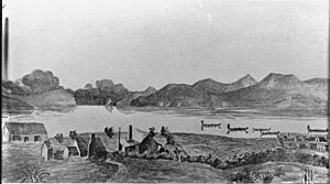
In the late 1840s, a mission was set up at Ihumātao. The area became a successful farming region, especially for wheat. Māori farmers produced goods to sell at the port of Onehunga. At this time, more Māori lived in Māngere than Europeans.
In 1863, the Governor ordered all Māori in South Auckland to declare loyalty to the Queen and give up their weapons. Many refused and moved south before the Invasion of the Waikato. Only six men stayed in Māngere to look after their farms. One chief, Ihaka Takanini, was arrested and later died.
European settlers took over the abandoned Māori settlements. In 1867, some land was returned to Māori, but much was kept by the Crown or sold to British farmers. Te Ākitai Waiohua people began to return to the area in 1866.
Growing as a Community
In 1862, the first local government was formed. The first school, Mangere Central School, opened in 1859. Churches were built in the 1870s and 1890s. Māngere became known for growing wheat and later for dairy farming. A dairy factory opened in 1887, supplying milk to Auckland. It closed in 1937. By 1915, Chinese New Zealand families started market gardens in Māngere.
Māngere stayed mostly rural until the mid-1900s. The Māngere Bridge area started to grow in 1875 after a bridge was built. Māngere East grew when the Otahuhu Railway Workshops opened in the late 1920s. The Pukaki Lagoon was even used as a speedway for a while! In the 1950s, Andrew Fistonich started the first vineyards, which became Villa Maria Estates.
In the 1950s, Chinese New Zealand gardeners Fay Gock and Joe Gock grew kūmara (sweet potatoes) on their farm. They developed a new type of kūmara that is now very common.
Modern Māngere
In 1958, the New Zealand Government chose Māngere for a new airport. Auckland Airport opened in 1966. In 1962, Māngere was chosen for a large state housing project. This was to provide homes for low-income families. By the 1980s, Māngere was one of the poorer areas in New Zealand. But by the early 2000s, it had become a very multicultural place.
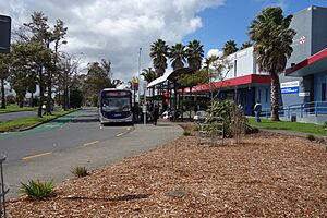
Major roads like State Highway 20 were extended to Māngere. There were also talks about building a light rail (a type of tram) system to connect Māngere to the city centre. However, these plans are currently on hold.
Cool Places to See
- Waterlea: A unique house on Ambury Road built with poured concrete.
- Barrow House: An old cottage on Church Road, built in 1841 and later made bigger.
- Rennie Farmhouse: A lovely house built in 1910 on Oruarangi and Ihumatao Road.
- Rennie-Jones Homestead: A two-storey house on Ihumatao Road built in 1885.
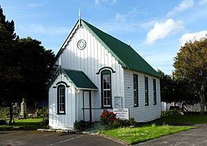
- Westney Road Methodist Church: Located on George Bolt Drive and Ihumatao Road. It was built in 1856 and made bigger in 1887.
- Massey Homestead: The old home of William Massey, who was a Prime Minister of New Zealand. It was built in 1852–1853 and is now a community centre.
- Abbeville Farm House: On Nixon Road, this was the home of Colonel Marmaduke Nixon. It was built in 1854.
- Mangere Presbyterian Church: On Kirkbride Road, built in 1874.
- Mangere Central School House: Also on Kirkbride Road, built around 1880. It was part of the first school in Māngere.
Who Lives in Māngere?
Māngere covers about 9.04 square kilometres. It has an estimated population of 24060 people as of June 2023, .
In 2018, Māngere had 21,363 people. This was an increase of over 2,000 people since 2013. About 28% of the people were under 15 years old.
Māngere is a very diverse place! The main ethnic groups are:
Many people in Māngere were born overseas (39.7%). Most people identify as Christian (64.7%).
Sports and Fun
The Māngere Arts Centre Ngā Tohu o Uenuku is a place for performing arts and art shows.
Māngere is home to several sports clubs:
- The Mangere East Hawks rugby league club at Walter Massey Park.
- The Manukau Rovers RFC rugby union club.
- The Mangere United football club.
Marae in Māngere
Māngere has three marae (traditional Māori meeting grounds):
- Makaurau Marae: This marae and its meeting house, Tāmaki Makaurau, are connected to the Ngāti Paretaua, Te Ākitai, and Ngāti Te Ata groups of Waikato Tainui.
- Pūkaki Marae: This marae and its meeting house, Te Kāhu Pokere o Tāmaki Mākaurau, are connected to the Ngāti Pare Waiohua from Te Ākitai Waiohua, and Te Ākitai, Ngāti Te Ata, and Ngāti Paretaua from Waikato Tainui.
- Mātaatua Marae: This marae and its meeting house, Awanuiarangi, are connected to the Ngāti Awa group of Ngāti Awa ki Tāmaki Makaurau.
Schools in Māngere
Māngere has a variety of schools for different age groups:
- Māngere College: A high school for students in years 9–13.
- Sir Douglas Bader Intermediate School: For students in years 7–8.
- Mangere Central School and Viscount School: Full primary schools for years 1–8.
- Jean Batten School and Nga Iwi School: Primary schools for years 1–6.
- Te Kura Kaupapa Māori o Māngere: A Māori-language school for years 1–13.
- Al-Madinah School and Zayed College for Girls: These are Islamic schools located next to each other. Al-Madinah is for years 1–13, and Zayed College for Girls is for years 7–13.
All these schools are coeducational (for both boys and girls), except for Zayed College for Girls.
Famous People from Māngere
- William Massey – He was the 19th Prime Minister of New Zealand.
- Frank Bunce – A famous rugby union player.
- Jonah Lomu – A legendary rugby union player.
- Joseph Parker – A well-known boxer.
- Jason Taumalolo – A talented rugby league player.
- Grant Baker – A successful businessman.
 | Emma Amos |
 | Edward Mitchell Bannister |
 | Larry D. Alexander |
 | Ernie Barnes |


