Onehunga facts for kids
Quick facts for kids
Onehunga
|
|
|---|---|
|
Suburb
|
|
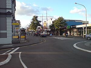
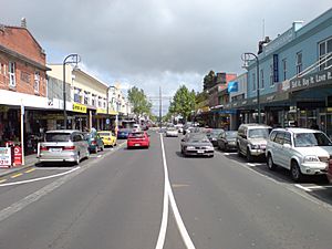
Onehunga Mall viewed from near the southern end
|
|
| Country | New Zealand |
| Local authority | Auckland |
| Electoral ward | Maungakiekie-Tāmaki ward |
| Local board | Maungakiekie-Tāmaki Local Board |
| Board subdivision | Maungakiekie |
| Established | 1843 (European) |
| Area | |
| • Land | 563 ha (1,391 acre) |
| Population
(June 2023)
|
|
| • Total | 12,430 |
| Train station(s) | Onehunga railway station |
|
|
||
Onehunga is a suburb in Auckland, New Zealand. It's home to the Port of Onehunga, a small port on the Manukau Harbour. Onehunga is about 8 kilometers (5 miles) south of Auckland's city center. It's also very close to the volcanic hill called Maungakiekie / One Tree Hill.
This area is a mix of homes and light industries. There are almost 1,000 businesses here. Onehunga stretches from Royal Oak in the north down to the Manukau Harbour. To the east are Oranga and Te Papapa. To the west is Hillsborough. On the other side of the Manukau Harbour, connected by two bridges, is the suburb of Māngere Bridge.
Contents
Exploring Onehunga's Location
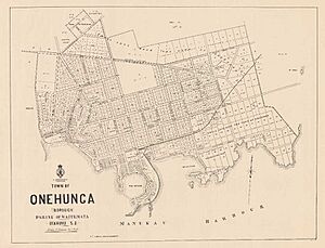
Onehunga is located on the Auckland isthmus, a narrow strip of land. It sits on the northern shore of Mangere Inlet, which is part of the Manukau Harbour. Just south of Onehunga is the volcanic cone of Maungakiekie / One Tree Hill.
The Port of Onehunga, on the Manukau Harbour, is now much smaller than Auckland's main port on the Waitematā Harbour. However, in the 1800s, the Onehunga port was actually bigger! The port's docks are built on land that was once a low volcanic crater called Te Hopua. This crater used to be a tidal lagoon, but it has been filled in.
Onehunga's side near the Manukau Harbour lost its direct access to the water when the Southwest Motorway was built in the 1970s. Only a tidal lagoon remains on the city side. However, there have been projects to restore the Onehunga foreshore. A new pedestrian and cycle bridge was built over State Highway 20 to connect the city park to the harbor.
Onehunga's Underground Water Supply
A large underground water source, called an aquifer, flows beneath Onehunga. This water comes from rainwater soaking through the lava around Maungakiekie / One Tree Hill. Up to 21 million liters of clean water are pumped from this aquifer every day. This water is treated and then supplied to Onehunga as part of Auckland's water network.
Most of Auckland's drinking water comes from large reservoirs. But the Onehunga aquifer provides about 5% of the city's water. Another major aquifer in Auckland, the Western Springs aquifer, is no longer used for drinking water.
Onehunga's Past: A Look Back
What's in a Name?
The name Onehunga comes from the Māori language. It means "a beach made of mixed sand and mud" or "alluvial soil." This describes the type of land found there.
Some people have suggested other meanings for the name. One idea was Ōnehunga, meaning "the place of burial." Another idea was Oneunga (or Oneūnga), meaning "beach" (one) and "landing" (ūnga), because canoes would land there. The New Zealand Geographic Board officially approved Onehunga as the name in 2019.
Māori History in Onehunga
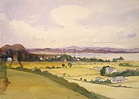
Onehunga was a very important area on the Auckland isthmus in pre-European times. Many battles happened here between different Māori groups. In the late 1830s, before many Europeans arrived, Onehunga was the main settlement for the Ngāti Whātua people. They had returned to the Manukau Harbour after moving away during the Musket Wars.
European Settlement and Growth
The European village of Onehunga was started in 1843 by Governor Grey. He settled former soldiers, called Fencibles, here. These soldiers, many from Ireland, were given land. In return, they were expected to defend the Auckland area if Māori groups threatened it. Onehunga was the first Fencible village in New Zealand. The Fencibles arrived in 1847.
Onehunga became the main European settlement around the Manukau Harbour. During the New Zealand Wars in the 1860s, naval volunteers from Onehunga carried out raids on Māori lands south of the harbor.
In 1863, during the Invasion of the Waikato, many women and children from smaller European settlements came to Onehunga as refugees. The Onehunga Ladies' Benevolent Society was formed to help them. This group was the oldest surviving women's organization in New Zealand until it closed in 2017.
Onehunga as a Busy Port
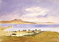
In the 1800s, most ships traveling between New Zealand and Great Britain came to Onehunga. They would sail around South Africa and Australia to get here. While some ships went to Auckland's east coast port, many chose Onehunga. This saved several days of sailing around North Cape.
However, the Manukau Harbour was dangerous. For example, HMS Orpheus sank there in 1863, and 180 people died. Despite this, coastal steamship lines carried almost all passengers and goods between Auckland and Wellington via Onehunga. Onehunga was the main way to travel to and from the south. Until 1908, a steamer from Onehunga was the fastest way to get from Auckland to Wellington, New Zealand's capital.
By the First World War, Onehunga was no longer a major commercial port. This was partly because ships became much larger and the Waitematā Harbour was wider and deeper. More importantly, the North Island Main Trunk railway was finished in 1908. This made coastal shipping much less profitable. Today, the port still serves some coastal traders and local fishing boats.
In 1874, Onehunga had 2,044 residents. In 1876, Onehunga became a borough, with its own mayor and council members.
Industry and Changes
From 1883 to about 1903, the Onehunga Ironworks operated in the town. It was located across from the original Onehunga railway station. Its tall chimney and some buildings remained until the late 1960s.
Starting in 1885, Onehunga became known for its wool industry. Several factories here produced blankets and other wool products. This weaving industry helped the area when the shipping trade slowed down after 1908.
The Onehunga foreshore (the area along the water) became a popular spot for families. This happened after the electric tram line was completed in 1906. The Tea Rooms at the tram stop, overlooking the harbor, were also a big attraction.
However, Onehunga later faced problems. When the municipal Abattoir (a place where animals are slaughtered) moved nearby, it started pumping toxic waste into the harbor. This ended Onehunga's role as a seaside resort and made it a less appealing place to live. By the late 1930s, the harbor water was very polluted. Fish and shellfish numbers dropped, and it became unsafe to eat any seafood. A large sewage treatment plant built in the 1960s made things even worse.
Luckily, things have improved a lot. The freezing works were closed, and the Manukau Sewerage Treatment Works were redesigned. Now, the water quality in the harbor has gotten much better.
In 1893, Elizabeth Yates became mayor of Onehunga. She was the first woman in the British Empire to hold such a position, even though she only served for one year.
Joining Auckland City
In 1891, Onehunga was one of New Zealand's 25 largest towns, with about 5,000 people. But by the First World War, it was no longer an important port. It found a new role as a shopping and service center as Auckland's suburbs grew and surrounded it. Onehunga officially joined Auckland City in 1989.
Onehunga briefly had Auckland's first zoo. However, the zoological garden created by John James Boyd near today's Royal Oak wasn't popular with locals. They worried about smells and crowds. So, in 1922, the animals were bought and moved to the new Auckland Zoo at Western Springs.
For much of the 1900s, Onehunga was mainly a working-class suburb. But since the 1990s, it has seen some gentrification, meaning the area has become more popular and homes have been improved. Many old bungalows and villas from the 1920s have been restored.
Onehunga is close to several secondary schools, including Onehunga High School, One Tree Hill College, and Marcellin College. Some boys also attend St Peter's College.
Onehunga's People
Onehunga is divided into four main areas for statistics: Onehunga West, North, Central, and Onehunga-Te Papapa Industrial. The first three are mostly residential and commercial, while the last is mainly industrial.
As of 2023, the residential areas of Onehunga (Onehunga West, North, and Central) have an estimated population of around 11,000 people.
In 2018, the population of the residential area was 10,902. About 18.4% of the people were under 15 years old. The main ethnic groups were European/Pākehā (57.0%), Asian (26.9%), Pacific peoples (16.3%), and Māori (10.4%). Many people (37.7%) were born overseas.
Most people in Onehunga (43.9%) said they had no religion. About 39.1% were Christian.
Restoring Onehunga's Foreshore
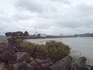
Onehunga's shoreline has been greatly changed by human activity. The old volcanic basin that connected to the Manukau Harbour was filled in. The shorelines were straightened for the Port of Onehunga, industrial uses, and sports fields. The extension of New Zealand State Highway 20 in the 1970s further cut off Onehunga from its harbor.
Local groups were upset about losing access to the water. They pushed for a restored beach. Eventually, money was set aside for a large new shoreline west of the motorway. This project included new pedestrian and cycle bridges to connect to downtown Onehunga. It also created 11 hectares (27 acres) of new beach and parkland.
In 2011, plans for the restoration were made clearer. They included a 6.4-hectare (15.8-acre) area with sandy beaches, new green spaces, and several new headlands. The area also got a new boat ramp, walking and cycling paths, and a new bridge over the motorway. Construction began on November 19, 2012.
The newly named Taumanu Reserve officially opened to the public on November 14, 2015. Over a thousand people attended the opening event.
Getting Around Onehunga
Train Travel
The Onehunga Line train services carry passengers between Onehunga railway station and central Auckland's Britomart Transport Centre. The trains run along the Onehunga Branch line, connecting to the main line at Penrose station.
There have been campaigns to extend the train line south from Onehunga. The idea is to cross the SH20 Manukau Harbour bridge and go all the way to Auckland Airport. This Auckland Airport Line is likely to be built after the City Rail Link project is finished.
Electric train services started running between Britomart and Onehunga on April 28, 2014.
Roads and Shopping
Queen Street, named after Queen Victoria, used to lead to the 1920s Māngere Bridge. This was one of the main land routes south out of Auckland. It was also the usual way to get to the airport until new motorways were built in the 1970s. These new roads took through traffic away from Onehunga and Mangere Bridge.
In 1973, Queen Street was closed to through traffic and renamed Onehunga Mall. It became a shopping area just for pedestrians. However, in 1996, Onehunga Mall was reopened to cars.
Until 1956, a tram line ran all the way from the Auckland CBD (city center) to Onehunga.
Famous Buildings in Onehunga
Onehunga has several interesting old buildings:
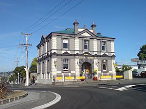
- Former Post Office: Built in 1902, this building on Princes Street and Onehunga Mall is an early example of the work of architect John Campbell.
- Anglican Church of St Peter: Located on Onehunga Mall and Church Streets. The original church from 1848 has been moved. The current building is from the 1980s and includes a Gothic-style tower from the 1930s. The churchyard has graves of early settlers and people who died in the Wreck of the Orpheus.
- Carnegie Free Library: This library on Princes Street opened in 1912. It was one of eighteen libraries in New Zealand built with money from the American philanthropist Andrew Carnegie. The building has recently been renovated and is now a restaurant.
- Church of the Assumption: This Roman Catholic church, built in 1889, is at the corner of Church and Galway Streets. It's a beautiful example of a Gothic church made of stone. Its cemetery also holds graves of many early Onehunga settlers.
- Scoria Blockhouse: At 19 Princes Street, this 19th-century building made of scoria (a type of volcanic rock) was used during the Land Wars of the 1860s, possibly as a hospital.
- The Landing: This 19th-century pub at 2 Onehunga Harbour Road was once on one of the busiest waterfronts in the country. It's one of the few buildings left from when Onehunga was an important port.
- War Memorial Arch: Located in Jellicoe Park, at Quadrant Road and Grey Street. It was opened in 1923 by the Governor General, Lord Jellicoe. Jellicoe Park also has Onehunga's public swimming pools. Near the arch is the beautiful John Park Memorial Fountain, which lights up for special events.
Jellicoe Park also has a collection of buildings that show the area's early history:
- Onehunga Blockhouse: A brick building from 1859, moved here from Princes Street.
- Journeys End: A copy of a wooden house from the 1850s, moved here in 1968.
- Laishley House: From 1859, moved here from Princes Street in 1985.
- Selwyn St Settlers Cottage: From 1850.
Across Grey Street from the park is:
- St Peter's Scout Den: This is the original 1848 Selwyn Church, moved here in 1980.
Nearby on Selwyn Street is:
- The former Onehunga Primary School: Built in 1901, this building is now a community center and has been recently restored.
On Alfred Street is:
- The former Onehunga railway station building: Moved to 38 Alfred Street, it is now the headquarters of the Railway Enthusiasts Society Inc.
Shopping in Onehunga
Dress Smart Auckland, a large outlet shopping center, opened in Onehunga in 1995. It expanded in 2005 and now has over 100 stores and many parking spaces.
Schools in Onehunga
Onehunga has several schools for different age groups:
- Onehunga High School: A secondary school for students in years 9–13.
- Onehunga Primary School: A primary school for years 1–6.
- St Joseph's Catholic School: A state-integrated primary school for years 1–8.
- Golden Grove School: A private Montessori primary school for years 1–8.
All these schools welcome both boys and girls.
Sports and Recreation
Onehunga is home to Onehunga Sports, a football club that plays in the Lotto Sport Italia NRFL Premier.
Waikaraka Park Speedway is a place for motorcycle speedway racing. It's located at 175-243 Neilson Street. This venue has hosted important events, including the North Island final round of the Speedway World Championship in 1992.
Notable People from Onehunga
- Margaret Beveridge Stevenson (1865–1941): A New Zealand follower of the Baháʼí Faith.
- Annie Christina Morrison: The first headmistress of Epsom Girls' Grammar School.
 | Claudette Colvin |
 | Myrlie Evers-Williams |
 | Alberta Odell Jones |


