
Māngere Bridge (suburb) facts for kids
Quick facts for kids
Māngere Bridge
|
|
|---|---|
|
Suburb
|
|

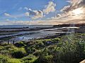
Western part of the suburb seen from Māngere Mountain.
|
|

Māngere Bridge
Location in New Zealand
|
|
| Country | New Zealand |
| Local authority | Auckland |
| Electoral ward | Manukau ward |
| Local board | Māngere-Ōtāhuhu Local Board |
| Area | |
| • Land | 645 ha (1,594 acre) |
| Population
(June 2023)
|
|
| • Total | 11,680 |
|
|
||
Māngere Bridge is a suburb in Auckland, New Zealand. It is managed by the Auckland Council. This area is the most north-western part of South Auckland. It is surrounded by the Manukau Harbour.
Māngere Bridge is connected to Onehunga in central Auckland by three bridges. These bridges cross the Māngere Inlet. The suburb has many features from the Auckland volcanic field. These include Māngere Mountain, a 106-metre-high volcano in the middle of the suburb. There is also Māngere Lagoon, a volcanic tidal lagoon across from Puketutu Island in the harbour.
The suburb is also home to Ambury Regional Park. This is a working farm and nature area run by Auckland Council. It connects to the Kiwi Esplanade and Watercare Coastal walkways. For hundreds of years, Tāmaki Māori lived here. Later, it became a Ngāti Mahuta settlement. This settlement helped defend Auckland from the late 1840s until the invasion of the Waikato in 1863.
From the late 1800s, Māngere Bridge was an important farming area. It supplied Auckland with food and dairy products. In the 1920s, many Chinese families started market gardens here. Māngere Bridge grew into a suburb in the 1950s and 1960s. Its growth was helped by its closeness to Auckland Airport, which opened in 1966.
In the early 2000s, old wastewater treatment ponds were closed. After this, the harbour around Māngere Bridge was greatly cleaned up. The suburb is very diverse, with many large families. Most houses are brick-and-tile homes built in the 1960s and 1970s. In 2019, the suburb's name was officially changed to Māngere Bridge, adding a special mark called a macron.
Contents
Exploring Māngere Bridge's Past
Early Māori Life and Settlements

Much of the land around Māngere Bridge was formed by lava flows from Māngere Mountain. People have been fishing here since at least the 1400s. Areas like Ambury Regional Park and Māngere Lagoon have about 100 old Māori sites. These include stone tools and shell heaps.
In the early 1700s, Māngere Mountain was a major pā (fortified village) for the Waiohua people. Thousands of people might have lived around the mountain. It was a central place for storing food. The chief, Kiwi Tāmaki, would stay at Māngere during shark hunting season.
Around 1740, Kiwi Tāmaki was defeated in battle by the Te Taoū group of Ngāti Whātua. Many Waiohua people left the area. Some Waiohua warriors gathered at Māngere Mountain. They spread pipi shells around the mountain to warn of attacks. But Te Taoū warriors covered the shells with dogskin cloaks to silence them. They then raided the pā at dawn. One of the mountain's names, Te Ara Pueru ("the dogskin cloak path"), remembers this event.
After this war, Ngāti Whātua Ōrākei settled the area. They were a new group formed by Te Taoū members who stayed in Auckland. They married Waiohua people. The iwi (tribe) first lived on Maungakiekie / One Tree Hill. But after their chief Tūperiri died around 1795, Māngere Bridge and Onehunga became their main settlements. They chose this spot for its good soil for gardening and resources from the Manukau Harbour. It was also a meeting point for trade routes.
Māngere and Onehunga were seen as one settlement. At low tide, people could easily walk across the Manukau Harbour. They used a natural rock path with a small stream. People lived here seasonally, moving around for fishing and gardening. They returned to Māngere-Onehunga in winter. Some people, like pig farmers, lived there all year. Ngāti Whātua Ōrākei mainly grew kūmara (sweet potato) in the Māngere Bridge area. This area was their main home until the 1840s, when they moved to Ōrākei.
Changes During Colonial Times
,_1853_-_Mangere_Bridge_cropped.jpg)
In the 1820s and early 1830s, Ngāpuhi raiders from the north caused many people to leave the Auckland area. During this time, a peace agreement was made between Ngāpuhi and Waikato Tainui. Ngāti Whātua returned to Māngere-Onehunga by the mid-1830s. They rebuilt a pā on Māngere Mountain called Whakarongo. In late 1837, Ngāti Mahuta people settled at Māngere Bridge. Ngāti Whātua had offered to share land with them.
On March 20, 1840, Ngāti Whātua chief Apihai Te Kawau signed the Treaty of Waitangi. He invited Governor William Hobson to settle in Auckland. He hoped this would protect the land and people. In 1840, Ngāti Whātua Ōrākei moved most of their people closer to the new European settlement in Auckland. A smaller Ngāti Whātua group stayed at Māngere-Onehunga.
In the late 1840s, Governor George Grey asked Pōtatau Te Wherowhero to settle his people in Māngere Bridge. Pōtatau Te Wherowhero was a powerful chief who later became the first Māori King. His people, known as the Māori Militia, were meant to defend Auckland. They settled on about 480 acres around Māngere Mountain. In 1847, the first ferry service started between Onehunga and Māngere Bridge.
The 1850s were good for the area. Māngere Bridge had a mix of Waikato-Tainui, Ngāti Whatua, Waiohua, and some European farmers. Māori people from the Manukau Harbour and Waikato sold or traded goods like peaches, melons, fish, and potatoes with Europeans. In 1858, Pōtatau Te Wherowhero moved away. Tāmati Ngāpora took over as leader of the Māngere settlement. In the late 1850s, the St James Anglican Church was built. It was a joint project between European settlers and the Ngāti Mahuta militia. They used rocks from Māngere Mountain.
This good time ended on July 9, 1863. Governor Grey ordered all Māori in South Auckland to declare loyalty to the Queen and give up their weapons. Most refused because of their strong ties to Tainui. They left for the south before the Invasion of the Waikato. Six men stayed in Māngere to care for the farms and keep their land rights. On May 16, 1865, the Ngāti Mahuta village at Māngere Bridge was taken by the government. European settlers often looted the empty settlements. In 1867, some of the seized land was returned to the Māori. The rest was kept by the government or sold to settlers.
Bridges, Farms, and New Growth

Plans for a bridge over the Māngere Inlet started in 1866. In 1875, the first Māngere Bridge opened. This helped Māngere Bridge become one of the first areas in Māngere to get suburban houses. In the late 1800s, Māngere Bridge was known for growing wheat, oats, barley, and potatoes. It also raised cattle for Auckland. The postal service arrived in 1878. By 1883, the first shop opened. In 1886, the first post office opened. In 1890, the Māngere Bridge School opened. More land was returned to Waikato tribes in 1890. A cottage was built for King Tāwhiao, the second Māori King. His family members used it when visiting Auckland or going to school there.
From the late 1880s, Māngere Bridge was a major supplier of dairy products to Auckland. A dairy factory opened in 1887. It supplied milk from local farms to stores in Auckland. The factory closed in 1937.
Market Gardens and Suburb Life

In 1915, a new, wider bridge opened across the Manukau Harbour. The old one had been closed because it was unsafe. The first Chinese New Zealanders arrived in the area in 1915. Ten years later, the first land was sold to a Chinese buyer. From the 1920s to the 1940s, many Chinese families owned and ran market gardens here. By 1954, more than half of the registered market gardens in the Māngere-Onehunga area were run by Chinese families.
Other businesses included a quarry that operated from the 1920s to 1963. There were also rope works. A dancehall and tearooms called the Oriental Rendezvous was built on the waterfront. It was a popular spot for Auckland nightlife until it burned down in 1932. In 1932, a water reservoir was built on top of Māngere Mountain. In the late 1930s, the area got electricity.
In the 1950s, Māngere Bridge changed from mostly rural to suburban. New houses were built. The Māngere Bridge town centre started to grow in the 1950s and 1960s. This is when the first banks were built in the suburb. In 1954, Māngere Bridge became a county town. In 1965, it became a suburb of the new Manukau City. In 1965, the Te Puea Memorial Marae opened. It later became a temporary shelter for people experiencing homelessness. The area saw a big increase in traffic after Auckland Airport opened in 1966.
Cleaning Up the Harbour and New Motorways

In 1960, the Manukau Sewage Purification Works opened. This plant used large ponds to treat wastewater for most of Auckland. These ponds were in the Manukau Harbour and Māngere Lagoon, reaching out to Puketutu Island. The ponds caused harm to the harbour environment. They destroyed traditional fishing spots and created strong bad smells. They also caused swarms of midges (small flies).
In 1961, the Māngere Residents' Protest Committee was formed. They wanted improvements or payment for the problems. The plant was updated in 1983, but the smell and midge problems continued. In the early 2000s, the ponds were closed. The treatment plant was upgraded to use special lights to clean the sewage. As part of the pond closure, work began to restore the harbour and shoreline. This led to the Watercare Coastal Walkway being built. More wading birds started returning to the harbour.
In 1970, planning began for State Highway 20, also known as the Southwestern Motorway. This new motorway would connect Auckland city to Auckland Airport. It included a new motorway bridge next to the existing Māngere Bridge. Construction on the bridge started in the mid-1970s. However, in May 1978, work stopped due to a long worker strike. The partially built bridge was protested for two and a half years. This was the longest continuous labour strike in New Zealand history.
The motorway bridge opened in 1983. By 2010, a parallel motorway bridge was built, making eight lanes. The entire Western Ring Route project, connecting different motorways, was finished in 2017. In November 2018, the old Māngere Bridge was closed for safety reasons. A new bridge for walking and cycling was planned to open by late August 2022. There are also plans for a light rail (tram) stop at Māngere Bridge. This might include a new crossing over the Māngere Inlet. However, after the 2023 election, light rail plans were put on hold. In 2019, the suburb's name was officially changed to Māngere Bridge, with a macron.
Māngere Bridge Today: People and Places
Who Lives Here?
Māngere Bridge covers about 6.45 square kilometres. It has an estimated population of about 10,296 people. This means there are about 1,596 people per square kilometre.
At the 2018 census, Māngere Bridge had 10,296 people. This was an increase of 1,035 people since 2013. There were 3,150 households. About 22.8% of people were under 15 years old.
The ethnic makeup of the suburb is diverse:
Many people identify with more than one ethnicity. About 27.0% of people were born overseas.
Regarding religion, 35.2% had no religion. 50.7% were Christian. Other religions included Māori religious beliefs, Hindu, Muslim, and Buddhist.
Important Buildings and Sites

- Māngere Bridge Village: This is the main shopping area. It grew in the 1950s and 1960s. The village has weekly Sunday markets and an annual Santa Parade. It also has the Māngere Bridge Library, opened in 1979. The Naomi and Bill Kirk Park is named after local community heroes.
- Māngere Memorial Hall: A public hall opened in 1955. It honours soldiers who served in the First and Second World Wars.
- Māngere Mountain Education Centre: This centre opened in 1995. It is like a living museum. Members of the Waiohua iwi share traditional knowledge. They teach storytelling, tool-making, gardening, and weaving. A house built for Tāwhiao, the second Māori King, was moved here in 2017.
- St James Anglican Church: This church opened in 1860. It was built from rocks from Māngere Mountain. Much of the work was done by the Ngāti Mahuta Māori Militia. It is a registered historic place.
- Te Puea Memorial Marae: This is a tribal meeting ground for the Waikato Tainui people. It includes a meeting house. The marae has helped many people find housing during times of homelessness. It follows the idea of manaakitanga (hospitality and care).
Beautiful Natural Areas
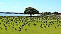
- Ambury Regional Park: This park opened in 1987. It is an archaeological site and a working farm. It hosts the annual Ambury Farm Day. Parts of the park are used by the Māngere Pony Club and a riding therapy charity. The Watercare Coastal Walkway connects Ambury Regional Park to Ōtuataua Stonefields.
- Kiwi Esplanade Walkway: This walkway goes along the Manukau Harbour. You can see smooth lava flows here. These flows came from the Māngere Mountain eruption about 50,000 years ago.
- Māngere Mountain / Te Pane-o-Mataaho / Te Ara Pueru: This is a volcano and a pā site. It is important to Waiohua and Ngāti Whātua Ōrākei history. The mountain was set aside as a public area in 1890. It was used for water, quarrying, and recreation.
- Māngere Lagoon: This is a volcanic lake and tidal lagoon. It was used for sewage treatment from 1959 to 2001. After that, it was cleaned up and is now part of the Watercare Coastal Walkway.
- Puketutu Island / Te Motu a Hiaroa: This island was the first permanent home for the Tainui people in Aotearoa. In the 1950s and 1960s, rocks from the island were used for projects like Auckland Airport. Since 2014, the island has been part of a project to rebuild the quarried areas using treated waste. After this project, the island will become a regional park and cultural centre.
Gallery
-
Nesting area for birds at Ambury Regional Park
-
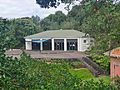
The Māngere Mountain Education Centre
-
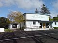
Māngere Memorial Hall
-
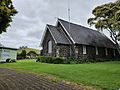
St James Anglican Church and Māngere Mountain
-
Variable oystercatchers along the Kiwi Esplanade Walkway
-
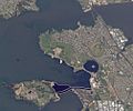
Satellite view of Māngere Bridge
-
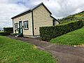
Restored cottage built for Tāwhiao, the second Māori King


Learning and Getting Around
Schools in Māngere Bridge

The Māngere Bridge area was first served by Māngere Central School, which opened in Māngere in 1859. The first school actually in the suburb was Māngere Bridge School, which opened in 1890. Later, Waterlea Public School (1955) and Mountain View School (1963) also opened. These three are primary schools for students in years 1–6.
Ambury Park Centre is a private high school for students with disabilities. It teaches students in years 9–13. Horse riding and caring for horses are important parts of their learning. Auckland Seventh-day Adventist High School is another high school for years 9–13. All these schools are for both boys and girls.
Transportation Options
Māngere Bridge can be reached by the Southwestern Motorway. This motorway first served the suburb when the motorway bridge opened in 1983. The motorway was fully completed in July 2017.
In October 2016, a new bus network started for South Auckland. Māngere Bridge is served by several bus routes. These connect the suburb to places like Māngere Town Centre, Auckland CBD, Onehunga, Manukau, and Auckland Airport. Māngere Bridge is also a planned stop for the City Centre-to-Māngere light rail project.
Community and Sports

Māngere Bridge is home to the Onehunga-Mangere United football club. This club moved its grounds to Māngere Mountain in 1965. An old quarry site was turned into sports grounds in 1965. It now hosts the Bridge Park Tennis Club and the Bridge Park Bowling Club. The Māngere Bridge Scouts Hall is also there. The scouting group has been in Māngere Bridge since 1920. The Chinese Community Sports Centre opened in October 1978.
Well-Known People from Māngere Bridge
- Alf Filipaina – a former community police officer and local council member.
- David Lange – a former Prime Minister of New Zealand.
- Willie Jackson – a politician and broadcaster.
- Mike King – a comedian and mental health advocate.
- Mahuta Tāwhiao – the third Māori King.
- Tumate Mahuta – a Ngāti Mahuta (Tainui) tribal leader.
- Tonga Mahuta – a Ngāti Mahuta tribal leader.
- Peter Murdoch – a former All Black rugby player.
- Waka Nathan – a former All Black rugby player.
- Tāmati Ngāpora – a preacher at St James Anglican Church and adviser to the Māori King.
- Pōtatau Te Wherowhero – the first Māori King.
- William Sio – a politician.
- Tāwhiao – the second Māori King.
- Jon Zealando – a magician who won a top magic award with his wife Janet in 1985.
