South Auckland facts for kids
Quick facts for kids
South Auckland
|
|
|---|---|
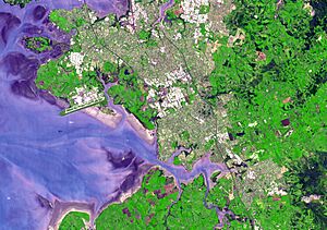
A satellite view of South Auckland in 2006
|
|
| Country | New Zealand |
| Island | North Island |
| Region | Auckland Region |
| NZ Parliament | Mangere Manurewa Panmure-Ōtāhuhu Papakura Takanini |
South Auckland (Māori: Te Tonga o Tāmaki Makaurau or Māori: Tāmaki ki te Tonga) is a large area in Auckland, the biggest city in New Zealand. It is located south of the Auckland isthmus and along the eastern side of the Manukau Harbour. People called Tāmaki Māori have lived here since at least the 1300s. There are important old sites, like the Ōtuataua stonefield gardens at Ihumātao and Māngere Mountain. Māngere Mountain was once a fortified village, or pā, important to the Waiohua tribes.
For a long time, South Auckland was mostly farmland. But in the mid-1900s, the Auckland Southern Motorway was built. This led to many new suburbs and the creation of Manukau City, which later became part of Auckland. Many state houses were built in the 1960s and 1970s. This helped Urban Māori and Pasifika communities grow in the area. South Auckland is now one of the most diverse places in New Zealand, with 165 different ethnic groups.
Contents
Understanding South Auckland's Location
South Auckland is not an exact place with clear borders. It usually means the western and central parts of the old Manukau City, which existed from 1989 to 2010. It also includes nearby areas of Franklin.
Key Areas in South Auckland
Some of the main areas in South Auckland are Māngere, Manukau, Manurewa, Ōtāhuhu, Ōtara, Papakura, and Papatoetoe. Sometimes, a more specific definition of South Auckland includes only the Māngere-Ōtāhuhu, Manurewa, Ōtara-Papatoetoe, and Papakura local board areas.
How the Name "South Auckland" Developed
The name "South Auckland" was first used in the 1880s. Back then, it referred to southern parts of the old Auckland Province, like Cambridge or Hamilton. The first time the name was used for the modern South Auckland area was in 1962. This was during talks about creating Manukau City. Since 1989, many groups have used "Counties Manukau" as another way to describe this region.
Exploring South Auckland's Natural Environment
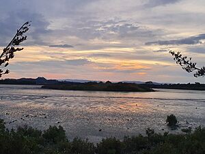
South Auckland is located on the eastern shores of the Manukau Harbour. It is also near the upper parts of the Tāmaki River. Many volcanic features from the Auckland volcanic field are found here. These include Māngere Mountain, Matukutūreia, and the Pukaki Lagoon. Some of these mountains, like Matukutūruru and Maungataketake, have been partly or fully quarried for stone.
Harbours and Rivers
Both the Manukau Harbour and the Tāmaki River are "drowned river valleys." This means they were once river valleys that became flooded by the sea. The Manukau Harbour formed millions of years ago. It changed from an open bay to a sheltered harbour as the Āwhitu Peninsula grew. Over time, the harbour has been a forested river valley and a flooded harbour, depending on global sea levels. The harbour we see today formed about 8,000 years ago.
Wetlands and Native Bush
Historically, much of inland South Auckland was covered by wetlands. Today, you can still find areas of native bush. For example, there is a taraire forest at Kirks Bush in Papakura. Parts of the Auckland Botanic Gardens in Manurewa also have native plants.
A Look at South Auckland's History
Early Māori History and Settlements
The Auckland area was an early stop for many Māori migration canoes, or waka. These included the Tainui and Aotea. One important place was Te Tō Waka, a portage at Ōtāhuhu. Here, waka could be carried across a narrow strip of land (only 200 metres wide) between the east coast and the Manukau Harbour. The Tainui waka's journey is remembered in the name of Ngarango Otainui Island.
Other portages were also important. The Waokauri and Pūkaki portages at Papatoetoe helped avoid Te Tō Waka. The Papakura portage connected the Manukau Harbour to the Wairoa River.
Tāmaki Māori people settled along the eastern coast of the Manukau Harbour as early as the 1300s. Their settlements depended on seasonal resources, like fish and shellfish from the harbour.
Ancient Gardens and Crops
In the 1400s, Tāmaki Māori created large garden areas at Ihumātao, Wiri, and on the slopes of Māngere Mountain. They used traditional Polynesian farming methods. Stone walls acted as boundaries, windbreaks, and drainage for their crops. These crops included kūmara (sweet potato), hue (calabash gourds), and taro. These special farming techniques helped them grow crops that usually needed a warmer climate.
Māori Tribes and Fortified Sites
Many early Tāmaki Māori tribes, or iwi and hapū, lived in South Auckland. Ngā Oho was a name for Tāmaki Māori who came from the Tainui and Te Arawa waka. Over time, groups like Ngā Riki settled between Ōtāhuhu and Papakura.
Many volcanic hills in South Auckland became fortified pā sites. These included Māngere Mountain, Matukutūruru, Matukutūreia, and Pukekiwiriki. There were fewer pā sites inland because the flat land was not good for building strong forts.
The Waiohua Confederacy
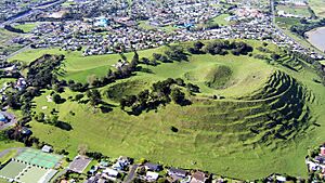
In the 1600s, three main Tāmaki Makaurau tribes joined to form the Waiohua confederacy. This union was led by the chief Huakaiwaka. Māngere Mountain was a very important pā for the Waiohua. It may have been home to thousands of people. The mountain also had many rua (food storage pits). The main chief, Kiwi Tāmaki, would stay at Māngere during shark hunting season in the Manukau Harbour.
Around 1740, a conflict between Ngāti Whātua and Waiohua led to the death of Chief Kiwi Tāmaki. Ngāti Whātua then became the main group living on the Tāmaki isthmus and in Māngere. Over time, Waiohua people who had moved south returned to South Auckland. This led to the development of new tribal identities like Te Ākitai Waiohua.
In the 1820s, during the Musket Wars, most of the Tāmaki Makaurau area became empty. People moved away to avoid war parties from the north. Ngāti Whātua and Waiohua went to the Waikato for safety. By the mid-1830s, Ngāti Whātua returned to the Māngere-Onehunga area. Waiohua descendant tribes also returned to their settlements, or papakāinga, in the 1840s.
Colonial Era and European Settlement

In 1836, a missionary named William Thomas Fairburn arranged a land sale with Tāmaki Māori chiefs. This sale covered most of modern-day South Auckland. However, it's not clear if the chiefs fully understood or agreed to the sale. Māori continued to live in South Auckland as before. The New Zealand government later reduced the size of Fairburn's land. Much of it was then divided for European settlers.
In 1840, Ngāti Whātua chief Apihai Te Kawau signed the Treaty of Waitangi. He invited Governor William Hobson to settle in Auckland. This was hoped to protect the land and people. Most Ngāti Whātua then moved closer to the new European settlement in Auckland City Centre.
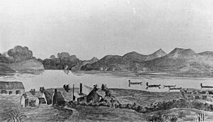
In 1846, the Wesleyan Methodist Church started a mission near Ihumātao. The next year, Governor George Grey created the village of Ōtāhuhu. This village was meant to protect Auckland. It was settled by retired British soldiers. Grey also asked Pōtatau Te Wherowhero, a powerful Māori chief, to settle at Māngere Bridge as another defense spot. Papakura was also settled by a few families in the late 1840s.
South Auckland grew in the 1850s. Manukau Harbour and Waikato tribes produced goods like corn, potatoes, and pigs to sell at the port of Onehunga. Ōtāhuhu became a busy farming and trade center. The Tāmaki River was one of New Zealand's busiest waterways.
In 1851, the Tāmaki Bridge was built on the Great South Road. This helped Papatoetoe grow. By 1855, the Great South Road reached Drury. Coal mining became a big industry in Drury. In 1862, one of New Zealand's first tramways was built to carry coal from the mine to the Manukau Harbour.
The Waikato War and Land Confiscation
In 1861, Governor George Grey ordered the Great South Road to be built further into the Waikato. This was due to fears of conflict with Waikato Tainui. In July 1863, Governor Grey told all Māori in South Auckland to swear loyalty to the Queen and give up their weapons. Most refused because of their strong ties to Tainui. They left for the south before the government's Invasion of the Waikato.
During the war, British troops built many forts and redoubts. This included St John's Redoubt on the Great South Road. Early battles happened around Drury and Pukekohe.
After the war, the Crown took 1.2 million acres of Māori land, including Waiohua land in South Auckland. Former residents began returning in 1866. The Native Compensation Court returned small parts of land in 1867. Most land was kept by the Crown or sold to British farmers.
Developing Farming Communities

Small farming communities grew along the Great South Road in the late 1800s. In 1875, the North Island Main Trunk railway started running in South Auckland. This connected the area to Auckland and the Waikato by train. The first Māngere Bridge opened in 1875, linking Māngere to Onehunga. South Auckland was known for growing wheat. Later, in the 1880s, dairy farming became popular.
In the 1890s, the wetlands of South Auckland were a major place for kauri gum digging. The Papakura Gumfield stretched from Manurewa to Clevedon. By the 1900s, these gumfields were turned into farms and orchards.
The first Chinese New Zealanders arrived in South Auckland in the 1910s. From the 1920s to the 1940s, many Chinese-owned market gardens operated here. In 1911, the first controlled powered flight in New Zealand happened in Takanini. It was piloted by Vivian Walsh.
In the 1920s, Papatoetoe and Manurewa became some of Auckland's fastest-growing areas. Māngere East also grew after the Otahuhu Railway Workshops opened in the late 1920s. During World War II, the Papakura Military Camp became an important base. Parts of Papatoetoe and Manurewa were used as military camps for the United States Army. Middlemore Hospital opened in 1947.
In the 1950s, Chinese New Zealand gardeners Fay and Joe Gock grew kūmara (sweet potatoes) at their farm. They developed a disease-resistant type of kūmara, which is now the common Owairaka Red variety.
Modern Suburban Growth
The building of the Auckland Southern Motorway in the mid-1950s caused a huge increase in people living in Papatoetoe and Manurewa. In 1958, New Zealand's first modern supermarket opened in Papatoetoe. In 1967, Southmall Manurewa, an American-style mall, opened.
South Auckland's population changed quickly from the 1950s to the 1970s. Māori from rural areas were encouraged to move to cities for work. The government built many state houses in areas like Ōtara and Māngere. Large numbers of Pasifika New Zealanders also began moving to New Zealand in the 1950s and 1960s. Many moved to South Auckland as central suburbs became more expensive.
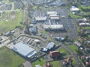
In 1965, Manukau City was formed. The new city decided to build a new center, which became Manukau. After this, South Auckland, from Ōtāhuhu to Papakura, became a continuous urban area.
In the mid-1970s, work began on State Highway 20 (the Southwestern Motorway) in South Auckland. This included a new motorway bridge next to the old Māngere Bridge. Construction stopped for two and a half years due to a workers' strike. The Auckland Botanic Gardens opened in Manurewa in 1982. The same year, Rainbow's End theme park opened in Manukau. It has since become the largest theme park in New Zealand.
In 1989, Manukau, Papatoetoe, and Howick joined to form the larger Manukau City. In 2010, all parts of the Auckland Region merged into one council, the Auckland Council. By the 2010s, areas like Papatoetoe became important centers for South Asian communities.
From 2016 to 2020, Ihumātao was occupied by protesters. They were concerned about a housing development on the historic site. In 2020, the New Zealand Government bought the land.
New suburban housing areas began to develop south of Papakura in the late 2010s. These include Paerata Rise and Auranga in Karaka. A big development is planned for the Drury-Ōpaheke area, which will be built in stages until the 2050s. New train stations will also be built between Papakura and Pukekohe.
South Auckland's Population and People
South Auckland covers about 167 square kilometers. In 2018, it had an estimated population of about 316,878 people. This means there are about 1,898 people per square kilometer.
| Historical population | ||
|---|---|---|
| Year | Pop. | ±% p.a. |
| 2006 | 259,227 | — |
| 2013 | 274,500 | +0.82% |
| 2018 | 316,878 | +2.91% |
At the 2018 New Zealand census, South Auckland's population was 316,878. This was an increase of over 42,000 people since 2013. There were 78,903 households. The population included 158,331 males and 158,547 females. About 25% of the people were under 15 years old.
Ethnic Diversity
South Auckland is very diverse. The ethnic groups were:
Many people identified with more than one ethnicity. About 38.5% of people were born overseas, which is higher than the national average of 27.1%.
Religion and Education
Regarding religion, 25.3% had no religion. About 48.6% were Christian. Other religions included Hindu (8.0%), Muslim (3.6%), and Buddhist (1.5%).
About 14.4% of people aged 15 or older had a bachelor's degree or higher. About 20.7% had no formal qualifications.
| Name | Area (km2) |
Population | Density (per km2) |
Ethnic groups | Households | Median age | Median income |
|||
|---|---|---|---|---|---|---|---|---|---|---|
| European | Māori | Pacific | Asian | |||||||
| Māngere-Ōtāhuhu Local Board Area | 52.47 | 78,450 | 1,495 | 19.1% | 16.4% | 59.4% | 19.0% | 17,880 | 29.0 years |
$24,700 |
| Ōtara-Papatoetoe Local Board Area | 37.12 | 85,122 | 2,293 | 16.6% | 15.7% | 46.0% | 35.1% | 20,412 | 29.1 years |
$25,900 |
| Manurewa Local Board Area | 37.10 | 95,670 | 2,579 | 29.2% | 26.0% | 36.3% | 25.4% | 23,562 | 29.5 years |
$27,400 |
| Papakura Local Board Area | 40.25 | 57,636 | 1,432 | 49.1% | 26.8% | 16.9% | 23.4% | 17,049 | 32.0 years |
$32,800 |
| Auckland region | 4,941 | 1,571,718 | 318 | 53.5% | 11.5% | 15.5% | 28.2% | 496,458 | 34.7 years | $34,400 |
| New Zealand | 268,021 | 4,699,755 | 18 | 70.2% | 16.5% | 8.1% | 15.1% | 1,653,792 | 37.4 years | $31,800 |
 | Selma Burke |
 | Pauline Powell Burns |
 | Frederick J. Brown |
 | Robert Blackburn |


