
Pukekohe facts for kids
Quick facts for kids
Pukekohe
|
|
|---|---|
|
Town
|
|

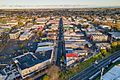
Pukekohe CBD, as seen from above
|
|
| Country | New Zealand |
| Region | Auckland Region |
| Ward | Franklin ward |
| Board | Franklin Local Board |
| Electorates |
|
| Area | |
| • Town | 31.03 km2 (11.98 sq mi) |
| Population
(June 2023)
|
|
| • Urban | 27,400 |
| Postcode |
2120
|
| Area code(s) | 09 |
Pukekohe is a lively town in the Auckland Region of New Zealand's North Island. It sits at the southern edge of the Auckland area, between the Manukau Harbour and the Waikato River. The hills of Pukekohe and nearby Bombay Hills mark the natural southern border of the Auckland region. Pukekohe is part of the Auckland Council area.
With a population of 27,400 (June 2023), Pukekohe is the 24th largest urban area in New Zealand. It is the third largest in the Auckland Region, after Auckland city itself and Hibiscus Coast.
Contents
About Pukekohe
Land and Landscape
Pukekohe and the areas around it are part of the South Auckland volcanic field. This area was formed by volcanoes that erupted between 550,000 and 1,600,000 years ago. This ancient volcanic activity has created very fertile soil, which is great for growing crops.
A Look at Pukekohe's Past
Early Māori Life
Tāmaki Māori people first settled in this wider area around the 13th or 14th centuries. The traditional Māori name for Pukekohe Hill is Pukekohekohe. This means "Hill of Kohekohe" and refers to a native tree, the New Zealand mahogany, which used to grow widely here.
The area was very important to local Māori tribes like Ngāti Tamaoho, Ngāti Te Ata, and Te Ākitai. They valued the strategic views from the hill and its rich soil. The northern slopes of the hill were home to some of the largest croplands (māra kai) for the Māori people living here.
Many people living around Pukekohe moved south during the Musket Wars in the 1820s. This was because of threats from northern tribes. They slowly started returning from the mid-1830s. Today, the main Māori tribes (iwi) in the area are Ngāti Tamaoho and Ngāti Te Ata. Waikato Tainui also has a strong connection here.
European Arrival and the New Zealand Wars
The New Zealand government, known as The Crown, bought the Pukekohe land block in 1843. They paid £150 in cash and £170 worth of goods. The Crown also set aside a special area, Te Awa nui o Taikehu, for the Te Ākitai Waiohua tribe. Sometimes, parts of this land were accidentally sold to settlers, but the Crown would fix this and return the land to the local Māori.
By 1856, European settlements were growing in Pukekohe. In 1863, Governor George Grey asked all Māori living south of Auckland to promise loyalty to the Queen and give up their weapons. Most refused because of their strong ties to the Tainui people and moved south before the government's Invasion of the Waikato. A few stayed to look after their farms and keep their land rights (known as ahi kā).
A major battle of the Waikato War happened at Pukekohe East on 14 September 1863. A small group of armed settlers were turning the Pukekohe East church into a fort. They were surprised by a much larger group of Māori fighters, mainly from the Waikato area. Even though they were outnumbered, the settlers held out until soldiers arrived. The church still stands today, and you can still see bullet holes in it.
After the Waikato War, the New Zealand Government took large areas of land in 1865. The town of Pukekohe was then established on the northern slopes of Pukekohe Hill. To encourage people to move here, the government offered land to migrants from Britain and the Cape Colony (South Africa). Over 3,000 immigrants came from Britain and about 1,200 from the Cape Colony.
Farming and Growth
Clearing the thick bush in Pukekohe opened up large areas of fertile, volcanic land perfect for growing crops. While onions and potatoes were grown here as early as the 1850s, large-scale vegetable farming began around 1870. After a gardener named John Bilkey successfully grew onions on Pukekohe Hill in 1892, more local farmers started growing them.
Better roads and railway lines in the late 1800s helped Pukekohe's market gardens grow. By 1875, Pukekohe was connected to Auckland by rail. This led to a big increase in Pukekohe's population. People who had lived in Te Awa nui o Taikehu also returned in the 1870s, often working in the market gardens. By 1885, Pukekohe had many farmers, professionals, and businesses.
The 20th Century and Beyond

In the early 1900s, many Māori from the Waikato area moved to Pukekohe to work in the market gardens. These Māori often had no family ties to the Pukekohe land. They became known as Nga Hau E Wha, meaning "People of the Four Winds."
Pukekohe became a town district in 1905. By 1907, its town centre had one main street with many shops. After the North Island Main Trunk railway line was finished in 1907, Pukekohe's market gardens became a major supplier of vegetables for cities like Auckland and Wellington. Pukekohe became a very important farming area for the Auckland Region as Auckland grew.
In 1912, Pukekohe became a borough with its own local council. The first Indian settler, Mitha Unka, arrived in 1918, and an Indian community grew in the town during the 1930s and 1940s.
During the 1930s, more Māori moved from rural areas to towns like Pukekohe. Many faced challenges finding housing due to unfair treatment. The Department of Māori Affairs tried to build houses for Māori workers, but the Pukekohe council objected to Māori living within the town's main areas.
During World War Two, from 1942 to 1944, Pukekohe hosted US Marines, US Army, and US Navy personnel.
In 1952, the Māori Women's Welfare League surveyed living conditions in Pukekohe. They found that Māori workers often lived in poor housing provided by their employers. The League reported this to the authorities, but many Māori still faced long waits for better housing.
Also in 1952, the Department of Education set up a separate school for Māori children in Pukekohe. This was due to pressure from some European residents who didn't want their children to mix with Māori. This went against the department's usual policy of integrated schools.
In 1963, a Chinese onion grower named Rai Wai Ching ran for a seat in the New Zealand Parliament. He wanted to highlight the unfair treatment faced by non-European people in Pukekohe, such as not being served in bars or getting worse seats at cinemas. Although he didn't win, his efforts brought attention to the issue, and the town eventually stopped this unfair treatment.
Culture
Marae
Ngā Hau e Whā Marae is located in the Pukekohe area. It is a special meeting place for the Ngāti Tamaoho tribe and the Waikato Tainui family groups (hapū) of Ngāi Tai and Ngāti Tamaoho.
Indian Community Centres
In 1953, the Nehru Hall was built in Pukekohe for the Indian community. It was the first Indian community hall in New Zealand. Later, in 1999, the Pukekohe Indian Association opened the larger PIA Events Centre to host bigger events like weddings.
Demographics
Pukekohe has grown a lot over the years. Between 1916 and 1936, its population grew by 65%. By 1936, it had 2,536 residents. The population nearly doubled from 3,309 in 1945 to 6,547 in 1966, partly due to the baby boom after the war. In 1991, Pukekohe had 10,410 people, and by 2001, it had 13,110.
Pukekohe covers about 31.03 km2 (11.98 sq mi) and has an estimated population of 27,400 as of June 2023. .
At the 2018 New Zealand census, Pukekohe had a population of 23,904. This was a big increase of 3,378 people (16.5%) since the 2013 census.
The people of Pukekohe come from many backgrounds:
(Some people identify with more than one ethnicity.)
About 24.3% of people in Pukekohe were born overseas. When it comes to religion, 46.3% said they had no religion, while 38.0% were Christian. Other religions included Māori religious beliefs, Hindu, Muslim, and Buddhist.
Education
Pukekohe has a range of schools for different age groups:
- Pukekohe High School is for older students (years 9–13) and has about 1,850 students. It opened in 1921.
- Pukekohe Intermediate School is for middle school students (years 7–8) with about 691 students. It opened in 1966.
- Primary Schools (years 1–6):
* Pukekohe East School (opened 1880) * Pukekohe Hill School (opened 1952 as Pukekohe Maori School, renamed 1966) * Valley School (opened 1966) * Tamaoho School (opened 2021) * These schools have rolls of 146, 523, 436, and 148 students respectively.
- Pukekohe North School is a full primary school (years 1–8) with about 310 students. A large number of its students are Māori, and some classes are taught in the Māori language. It opened in 1957.
- State Integrated Schools:
* KingsGate School is an interdenominational Christian school for years 1–13, with about 219 students. It opened in 1996. * St Joseph's School is a Catholic primary school (years 1–6) with about 246 students. It opened in 1923.
- Parkside School is a special school for students with special needs up to age 21, with about 141 students.
All these schools are for both boys and girls. Student numbers are as of February 2024. .
Sports and Recreation
Pukekohe is a hub for sports!
- Pukekohe Park Raceway is a famous place for motorsports and horse racing. It opened in 1963 and has hosted many big events, including the New Zealand Grand Prix and the V8 International car races. The last race was held in 2022.
- Rugby Union: Pukekohe RFC represents the town in rugby union. Their main field is nicknamed the 'Onion Patch'. The Counties Manukau Rugby Football Union is based in Pukekohe and plays home games at Navigation Homes Stadium. Their men's team, the "Steelers," and women's team, the "Heat," play in national championships.
- Football: Pukekohe AFC is the local football club. They share the Bledisloe Park Sports Centre with the Pukekohe Metro Cricket Club.
- Other Sports:
* Auckland Metropolitan Clay Target Club offers clay target shooting. * Puni Mountain Bike Track has about 6–7 km of trails. * Sunset Coast BMX and Puni Rugby Club are also at Puni Memorial Park. * The New Zealand National Basketball League team, the Franklin Bulls, plays home games at the Franklin Pool and Leisure Centre, known as 'The Stockyard'. * The town also has a golf club, tennis club, squash club, and a hot rod club.
Media
Pukekohe has several local media outlets:
- Rural Living is a monthly magazine about lifestyle in the Franklin region.
- Franklin County News is a local newspaper delivered weekly to homes in Pukekohe and nearby towns.
- The Post Newspaper publishes almost 22,000 copies weekly.
- Franklin Life NZ is an online calendar and photo news website launched in 2015.
In 2013, the film Mt. Zion was released in New Zealand. It showed Māori life in Pukekohe during the 1970s.
Transport
Pukekohe railway station is an important transport hub. It's on the North Island Main Trunk Railway and is the southernmost station of the Auckland rail network, at the end of the Southern Line. The government announced funding in 2020 to extend the electric train lines from Papakura to Pukekohe, which will make train travel even better.
Notable People
Many well-known people have connections to Pukekohe:
- Bill Birch, a former Member of Parliament.
- Joeli Vidiri, a former All Black rugby player.
- Possum Bourne, a famous World Rally Championship driver.
- Eric Murray, a double Olympic Gold Medalist in Rowing. He went to Pukekohe High School.
- Leslie Comrie, an astronomer and pioneer in mechanical computation.
- Simon Doull, a New Zealand Blackcaps cricket player and radio personality.
- Peter Fa'afiu, a diplomat and global director for Amnesty International.
- A. J. Hackett, an entrepreneur who helped make bungee jumping popular.
- Liam Lawson, a Formula 1 racing driver who grew up in Pukekohe.
- Jonah Lomu, a legendary All Black rugby player, born in Pukekohe.
- Rex Mason, a former mayor and Member of Parliament.
- Carl Ruiterman, a racing driver.
- Malietoa Tanumafili II, the former Head of State of Samoa.
- Allan Wilson, a molecular biologist who grew up in the area.
Climate
| Climate data for Pukekohe (1991–2020) | |||||||||||||
|---|---|---|---|---|---|---|---|---|---|---|---|---|---|
| Month | Jan | Feb | Mar | Apr | May | Jun | Jul | Aug | Sep | Oct | Nov | Dec | Year |
| Mean daily maximum °C (°F) | 23.5 (74.3) |
24.1 (75.4) |
22.6 (72.7) |
20.1 (68.2) |
17.4 (63.3) |
15.1 (59.2) |
14.3 (57.7) |
14.8 (58.6) |
16.2 (61.2) |
17.6 (63.7) |
19.3 (66.7) |
21.6 (70.9) |
18.9 (66.0) |
| Daily mean °C (°F) | 18.8 (65.8) |
19.4 (66.9) |
17.9 (64.2) |
15.8 (60.4) |
13.5 (56.3) |
11.4 (52.5) |
10.5 (50.9) |
11.0 (51.8) |
12.3 (54.1) |
13.6 (56.5) |
15.1 (59.2) |
17.3 (63.1) |
14.7 (58.5) |
| Mean daily minimum °C (°F) | 14.1 (57.4) |
14.7 (58.5) |
13.3 (55.9) |
11.4 (52.5) |
9.6 (49.3) |
7.7 (45.9) |
6.7 (44.1) |
7.1 (44.8) |
8.4 (47.1) |
9.7 (49.5) |
10.9 (51.6) |
13.1 (55.6) |
10.6 (51.0) |
| Average rainfall mm (inches) | 71.2 (2.80) |
64.3 (2.53) |
80.3 (3.16) |
98.5 (3.88) |
124.5 (4.90) |
137.2 (5.40) |
146.5 (5.77) |
130.7 (5.15) |
108.4 (4.27) |
100.3 (3.95) |
88.0 (3.46) |
93.1 (3.67) |
1,243 (48.94) |
| Source: NIWA | |||||||||||||
Images for kids
-
Pukekohe CBD, as seen from above
-
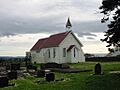
Pukekohe East Church
