
Māngere East facts for kids
Quick facts for kids
Māngere East
|
|
|---|---|
|
Suburb
|
|

Aerial view of Māngere East, with the Māngere Inlet and Ōtāhuhu in the background (2009).
|
|

Māngere East
Location in New Zealand
|
|
| Country | New Zealand |
| Local authority | Auckland |
| Electoral ward | Manukau ward |
| Local board |
|
| Area | |
| • Land | 590 ha (1,460 acre) |
| Population
(June 2023)
|
|
| • Total | 29,050 |
| Postcode(s) |
2024
|
| Railway station(s) | Middlemore Railway Station |
|
|
||
Māngere East is a suburb in Auckland, New Zealand. It is managed by the Auckland Council. You can find it south of Favona and north of Papatoetoe. To its west are Māngere and Māngere Bridge, and to its east is Middlemore. Ōtāhuhu is to its northeast.
In 2019, the name of the suburb was officially changed to Māngere East.
Contents
Geography
Māngere East is located in South Auckland. It sits east of central Māngere. The suburb is found between the Southwestern Motorway and the Southern Line railway.
History
Early Māori Settlement
People from the Tāmaki Māori tribes first lived in the Māngere area around the 14th century. The first settlements appeared in the 15th century. Māngere East was an important part of the Waokauri / Pūkaki portage. This was a special path that connected the Manukau Harbour and Tāmaki River. It was often used by Tāmaki Māori to avoid other portages controlled by people living at Ōtāhuhu / Mount Richmond. The area is part of the traditional lands of the Waiohua tribes, including Te Ākitai Waiohua.
European Settlement and Land Changes
In January 1836, a missionary named William Thomas Fairburn helped arrange a land sale. This sale was between Tāmaki Māori chiefs and covered most of what is now South Auckland. The idea was to stop fighting in the area. However, it's not clear if the chiefs fully understood or agreed to the sale. Māori people continued to live in South Auckland as before.
Fairburn was later criticized for buying such a huge amount of land. In 1842, the Crown (the government) greatly reduced the size of his land. Much of this land was then given to European settlers.
Until the 1860s, Māori people in the Manukau Harbour and Waikato areas grew goods to sell or trade at the port of Onehunga.
Waikato War and Local Government
On July 9, 1863, Governor Grey was worried about the Māori King Movement. He announced that all Māori living in South Auckland needed to promise loyalty to the Queen and give up their weapons. Most people refused because they had strong connections to the Tainui tribes. They moved south before the government's Invasion of the Waikato began.
In 1862, the first local government was set up in the area. It was called the Mangerei Highway Board.
Growth and Development
Māngere East was mostly a rural area for a long time. It had many large country homes, like the Massey Homestead. This was the former home of William Massey, who became the Prime Minister of New Zealand.
Māngere East and Ōtāhuhu slowly started to grow after 1908. This was when the North Island Main Trunk railway line connected Auckland to Wellington. The Māngere railway station also opened around this time.
Māngere East really began to develop as a suburban area after the Otahuhu Railway Workshops opened in the late 1920s. One of the first new housing areas was the Massey Park subdivision. The Mangere East Hall opened in 1924. It was used for community events and even as a cinema. Mangere East School opened in 1927.
During World War II, Māngere East became home to Camp Euart. This was a large military camp for the United States Military. It covered 84 acres and housed 5,000 troops.
By 1955, the area had grown enough to become its own town district. Ten years later, in 1965, the Māngere East town district became part of the new Manukau City. The wider area saw even more suburban growth in the 1960s and 1970s. This was when central Māngere was developed with many new houses. Māngere East then became a suburb of Manukau City.
Demographics
Māngere East covers about 5.90 square kilometers. As of 2023, it has an estimated population of over 27,000 people. This means there are many people living in a relatively small area.
The population of Māngere East has been growing. For example, between the 2013 and 2018 censuses, the population increased by over 2,000 people.
The people living in Māngere East come from many different backgrounds. In 2018, the population included:
- About 13% European/Pākehā
- Around 16% Māori
- Over 65% Pacific peoples
- About 20% Asian
- A small percentage of other ethnicities.
This shows that Māngere East is a very diverse community. Many people living here were born overseas, which adds to the rich mix of cultures.
When it comes to religion, most people in Māngere East identify as Christian. There are also significant numbers of people who follow Hinduism and Islam, as well as other religions or no religion.
Education
Māngere East has several schools for different age groups:
- Kedgley Intermediate School is for students in years 7–8.
- Robertson Road School, Mangere East School, and Sutton Park School are full primary schools. They teach students from years 1–8.
- Kingsford School and Papatoetoe North School are contributing primary schools. They teach students from years 1–6.
- St Mary MacKillop Catholic School is a state-integrated full primary school for years 1–8.
- De La Salle College is a state-integrated Catholic secondary school for boys. It teaches students from years 7–13.
All these schools are coeducational (for both boys and girls), except for De La Salle College, which is a boys' school.
Community Facilities
Māngere East has places for the community to gather and enjoy:
- Tri Duc Temple is a Vietnamese Buddhist temple located in the suburb.
- Walter Massey Park is a large public park. It is home to several sports clubs, including the association football club Manukau United FC and the rugby league club Mangere East Hawks. The park also has the Māngere East Library, the historic Māngere East Hall, and the Māngere East Community Centre.
Notable People
Some well-known people have connections to Māngere East:
- William Massey – He was the Prime Minister of New Zealand from 1912 to 1925.
- Tupou Neiufi – A talented athlete who has competed in the Commonwealth Games and Paralympics.
Images for kids
-
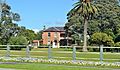
Massey Homestead, a 19th-century country manor and former home of Prime Minister William Massey
-
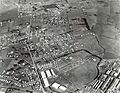
Aerial view of Māngere East in 1949, showing the former Camp Euart and the Otahuhu Workshops
.jpg)

