
Puketutu Island facts for kids
Quick facts for kids Te Motu a Hiaroa |
|
|---|---|
| Puketutu Island | |

The motu (island) today, from Mangere Mountain
|
|
| Highest point | |
| Elevation | 65 m (213 ft) |
| Geography | |
| Location | North Island, New Zealand |
| Geology | |
| Volcanic arc/belt | Auckland volcanic field |

Te Motu a Hiaroa (also known as Puketutu Island) is a volcanic island in the Manukau Harbour, New Zealand. It is part of the Auckland volcanic field, a group of volcanoes in the Auckland area. Early European settlers called it 'Weekes' Island', but people eventually started using its original Māori name again.
The island is connected to the mainland by a road called Te Ara Tāhuna.
The name Te Motu a Hiaroa means "the island of Hiaroa". This refers to an ancestor who arrived on the island after a long journey on the Tainui waka (canoe). Puketutu is another name for the island. It refers to one of the many maunga (mountains) and puke (hills) found there. The New Zealand Ministry for Culture and Heritage says that Puketutu means "tutu shrub hill".
Contents
History of Te Motu a Hiaroa
In Māori traditions, Te Motu a Hiaroa is connected to Mataaoho. Mataaoho is a deity (a god or spirit) linked to volcanic activity. Māori stories say that Mataaoho created the volcanoes in the Auckland area. This creation is known as Te Riri o Mataaoho, or 'the wrath of Mataaoho'.
The island once had several volcanic cones and hills. These were used by Māori for building pā (fortified villages) and tuahu (sacred altars). The rich soil from lava flows was perfect for gardening. People grew kumara (sweet potatoes) and other crops there. This was similar to the Otuataua Stonefields nearby.
Guardians and Learning
It is believed that several guardian taniwha (mythical water creatures) protect the island. Te Motu a Hiaroa is also strongly linked to the arrival of the Tainui waka around the 14th century.
From its earliest days, important Māori leaders lived on the island. These included tohunga (experts or priests) and rangatira (chiefs). Because of this, the island became known as a place of tohunga. It was also a whare wānanga, which means a house of learning. Here, people learned traditional Māori mātauranga (knowledge) and tikanga (customs and practices). The island is considered very special and sacred to the Tainui and Te Waiohua iwi (tribes) and hapū (sub-tribes).
In the mid-19th century, during the time of colonisation, the original Māori owners of the island lost control of their land.
Changes to the Island
In the 1950s, many of the island's volcanic cones were heavily quarried. This means their rocks were dug up and removed. This material was used to help build the nearby Auckland Airport. Also, large ponds for treating wastewater were built next to the island.
The highest point of the island, Te Taumata a Rakataura (Pinnacle Hill), which is 65 meters high, was kept. Sir Henry Kelliher owned the island from the 1940s. His charitable trust later suggested a plan. They wanted to use treated waste material from the nearby Mangere wastewater plant to help reshape the island. This process would take many years. The main goal was to return the island to its Māori customary owners. It would also create a beautiful open space for everyone in Auckland to enjoy.
Future of the Island
Today, Watercare (a water company) has a long-term lease of the island. They have also transferred the island's ownership to the Te Motu a Hiaroa (Puketutu Island) Charitable Trust. This trust includes representatives from Waikato-Tainui, Te Kawerau a Maki, and Makaurau Marae/Te Ahiwaru Waiohua.
The Te Motu a Hiaroa Charitable Trust plans to bring back the whare wānanga (place of learning). They are working with Auckland Council to restore the island. Their goal is to create a cultural park that people from all over Auckland can visit and enjoy.
Images for kids
-
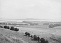
Puketutu Island (then called 'Weekes' Island') in the 1910s, before it lost most of its cones to quarrying.
-
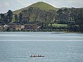
Puketutu Island's Pinnacle Hill, with a waka or canoe in the foreground.


See also
 In Spanish: Isla de Puketutu para niños
