
Mount Albert, New Zealand facts for kids
Quick facts for kids
Mount Albert
|
|
|---|---|
|
Suburb
|
|

The town centre, dominated by New North Road
|
|

Mount Albert
Location in New Zealand
|
|
| Country | New Zealand |
| Local authority | Auckland |
| Electoral ward | Albert-Eden-Puketāpapa ward |
| Local board | Albert-Eden Local Board |
| Area | |
| • Land | 504 ha (1,245 acre) |
| Population
(June 2023)
|
|
| • Total | 13,060 |
| Train station(s) | Baldwin Avenue railway station Mount Albert railway station |
|
|
||
Mount Albert (Māori: Ōwairaka) is a lively suburb in Auckland, New Zealand. It's named after Ōwairaka / Mount Albert, a volcanic peak that stands tall in the area. By 1911, Mount Albert grew so much it became its own town, called a borough. Later, it became part of Auckland. The suburb is about 7 kilometers southwest of Auckland's city center.
Contents
Geography of Mount Albert

Mount Albert is built around Ōwairaka / Mount Albert, an old volcano that erupted about 120,000 years ago. It's one of the oldest volcanoes in the Auckland volcanic field. About 28,000 years ago, another volcano, Te Kōpuke / Mount Saint John, erupted. Its lava flow reached northern Mount Albert and created the Meola Reef in the Waitematā Harbour.
The Oakley Creek is a big stream in Auckland. It forms the western edge of the Mount Albert suburb.
History of Mount Albert
Early Māori History
.jpg)
One of the first names Tāmaki Māori gave to the volcano was Te Puke o Ruarangi, meaning 'The Hill of Ruarangi'. A traditional story tells of Ruarangi, a chief of the magical Patupaiarehe people, escaping a battle on the volcano through secret lava tunnels. Other old names include Te Ahi-kā-a-Rakataura, meaning 'the long burning fires of Rakataura'. This name refers to the Tainui explorer Rakataura, who lived there for a long time.
The name Ōwairaka comes from Wairaka, an important Māori ancestor. She was the daughter of Toroa, the captain of the Mātaatua canoe. Wairaka came to Auckland to avoid a marriage she didn't want. She then settled her people on the volcano.
In the early 1700s, the Auckland isthmus had many people from the Waiohua tribes. Ōwairaka / Mount Albert was their westernmost hill-top pā (fortified village). It had many terraces and gardens. After a conflict between Waiohua and Ngāti Whātua in the mid-1700s, the area became part of Ngāti Whātua's land. Ngāti Whātua preferred living by the sea, so much of the area was not used as much. Oakley Creek was important to Tāmaki Māori for gathering crayfish, eels, and weka. They also harvested New Zealand flax and raupō from the creek banks to make Māori traditional textiles.
In 1820, an English priest named Samuel Marsden visited the area. He climbed Ōwairaka / Mount Albert with Apihai Te Kawau, the main chief of Ngāti Whātua. The mountain was later named after Prince Albert, the husband of Queen Victoria, during the early colonial period.
European Settlement and Growth

On June 29, 1841, Ngāti Whātua sold Mount Albert to the Crown. The land was rough, so it developed slower than other parts of Auckland. In the 1860s, New North Road was built. This road gave access to the area and was an alternative to the Great North Road. Mount Albert became a place for wealthy landowners to build large estates. This was because it was close to Auckland city. Big houses like Alberton and Ferndale House were built for these families.
The Mt Albert Methodist Church was built in 1866. Later that year, the Mt Albert District Highway Board was formed. This was the first local government in the area. The first school, Mt Albert School, opened in 1870. It was built on land given by John McElwain.
Early society in Mount Albert often revolved around the Anglican Church. Important figures included pioneer Allan Kerr Taylor and his wife Sophia Taylor. The Kerr Taylor family changed their home, Alberton, in the early 1870s. They made it into a grand mansion inspired by Anglo-Indian style, where many fancy events were held.
The Mount Albert railway station opened in March 1880. This connected Mount Albert to Auckland city by train and helped the suburb grow. In the 10 years after 1881, Mount Albert's population doubled to 1,400 people. In the late 1800s, a quarry was started on Ōwairaka / Mount Albert. It had a train track connecting it to the North Auckland Line. People living nearby were worried about the mountain. They asked the government to stop the quarry in 1895 and 1915. The quarry was finally closed in 1928.
Suburban Development and Modern Mount Albert

By the 1910s, Mount Albert was one of Auckland's fastest-growing suburbs. Many families, especially successful business people, moved there. They wanted large family homes but still needed to travel to Auckland for work. By 1911, the population reached 6,666. In 1912, the King George V Hall opened, becoming a social center. The area still had many dairy and poultry farms. In 1915, the Auckland tramline reached the suburb. This led to the growth of the Mount Albert shopping area, first called Ohlsen's Corner. As the shops grew, the area became known as "the Terminus" because it was the last stop on the tramline.
Mount Albert became its own borough on April 1, 1911. The borough borrowed money to improve the water supply. Between 1901 and 1931, the population jumped from 2,035 to 20,600. This made Mount Albert the largest borough in New Zealand. After World War II, there was a big housing shortage. Many state housing areas were built, including the Stewart Estate in Mount Albert.
The Mount Albert shops did very well in the 1950s and 1960s. In April 1961, the Mount Albert War Memorial Hall, a large modern community center, was built. From the 1950s, more Urban Māori and Pasifika communities moved to the area. This increased in the 1970s as inner-city suburbs became more expensive. The Mount Albert shopping area started to decline in the 1970s after the St Lukes Shopping Centre opened nearby.
By the 1990s, Mount Albert became a very multicultural place in Auckland. There was a growth in Indian, Sri Lankan, and Chinese communities. This was partly because of two colleges in the area: Unitec Institute of Technology and the Auckland Institute of Studies.
Demographics of Mount Albert
Mount Albert covers about 5.04 square kilometers. As of 2023, it has an estimated population of about 12,666 people. This means there are about 2,513 people per square kilometer.
| Historical population | ||
|---|---|---|
| Year | Pop. | ±% p.a. |
| 2006 | 12,036 | — |
| 2013 | 12,228 | +0.23% |
| 2018 | 12,813 | +0.94% |
| 2023 | 12,666 | −0.23% |
In the 2023 New Zealand census, Mount Albert had 12,666 people. This was a small decrease from 2018 but an increase from 2013. There were slightly more females than males. About 18.7% of people were under 15 years old.
People in Mount Albert come from many different backgrounds. About 63.5% identified as European (Pākehā). Other groups included Māori (10.8%), Pasifika (10.1%), and Asian (26.4%). English is spoken by most people (93.8%). Many other languages are also spoken, including Māori and Samoan. About 35% of people were born outside New Zealand.
Many different religions are practiced in Mount Albert. About 29.9% are Christian. Other religions include Hindu, Islam, and Buddhist. More than half of the people (54.3%) said they had no religion.
Many adults in Mount Albert have a high level of education. About 44.2% of people aged 15 or older have a bachelor's degree or higher. Most adults are employed full-time or part-time.
Notable Buildings and Landmarks

Mount Albert has many interesting buildings and places:
- Mt. Albert War Memorial Park: A park located at 773 New North Road.
- Mt. Albert War Memorial Hall: A large, modern community center built in 1960 to remember those who served their country.
- Rocket Park: A children's playground from the early 1960s. It has metal climbing structures shaped like planets and spaceships.
- Mount Albert Baptist Church: A modern church from the 1950s at 732 New North Road.
- St Mary's Catholic Church: A Roman Catholic Church at 10 Kitenui Ave.
- Marist School: A Roman Catholic primary school on Alberton Avenue.
- Marist College: A Roman Catholic secondary school for girls at 31 Alberton Ave.
- Ferndale House: A wooden house built in 1865 and extended in 1881. It's now a community venue. It has huge Norfolk pine trees.
- Mt Albert Methodist Church: A wooden Gothic church at 831 New North Road.
- Mount Albert Railway Station: Opened in 1880 and upgraded between 2013 and 2016.
- Former Deluxe Cinema: A building from the 1920s at 960 New North Road.
- Mt. Albert Presbyterian Church: Located at 14 Mt. Albert Road.
- Alberton: A large wooden house with unique turrets at 100 Mt. Albert Road. It was the home of Allan Kerr Taylor. It's now owned by the New Zealand Historic Places Trust. People have reported strange things happening there!
- Crown Research Institute: A modern high-rise building from the 1960s at 120 Mt. Albert Rd.
- Mount Albert School: A primary school on Taylor's Road, built in its current spot in 1940.
- Mount Albert Grammar School: A school on Alberton Avenue with a main building from the 1920s. It's special because it has an agricultural department, which is rare for a city school.
- Mt. Albert Aquatic Centre: A swimming center at 38 Alberton Ave.
- Winstone House: A late 19th-century house on the slopes of Mt. Albert. It was moved here around 1910.
- Caughey House: A unique house with a turret at 15 McLean Street. It was built for Andrew Caughey, who owned a department store. It's now part of Hebron Christian College.
- Former St Helens Hospital: Opened in 1968 and closed in 1990. It's now the St Helens Campus of the Auckland Institute of Studies.
Famous People from Mount Albert
Many well-known people have lived or grown up in Mount Albert. Rugby player Sonny Bill Williams and actress Lucy Lawless both grew up here. Former Prime Minister Helen Clark, famous sound expert Sir Harold Marshall, and TV presenter Petra Bagust live here now.
Famous New Zealand athlete Peter Snell, who won three Olympic gold medals, lived in Mount Albert for a long time. Bryan Williams, a great All Black rugby player, also lived here.
Education in Mount Albert
Mount Albert has several schools and colleges:
- Marist College: A Catholic girls' secondary school (years 7–13). It started in 1928.
- Marist School: A Catholic primary school (years 1-6) on the same site as Marist College.
- Mount Albert School and Gladstone Primary School: Both are primary schools (years 1-6).
- Te Kura Kaupapa Māori O Nga Maungarongo: A primary school (years 1–8) where students learn mostly in the Māori language.
All these schools, except Marist College, are for both boys and girls.
For older students, there are two colleges: Auckland Institute of Studies and Unitec.
Sports in Mount Albert
Mount Albert is home to several sports clubs:
- Association Football (Soccer):
- Metro F.C. plays in the Lotto Sport Italia NRFL Premier league.
- Mount Albert-Ponsonby plays in the Lotto Sport Italia NRFL Division 2 league.
- Rugby League:
- The Marist Saints
- The Mount Albert Lions (who separated from Marist in 1927).
Both clubs play in the Auckland Rugby League's top division, the Fox Memorial.
Climate in Mount Albert
| Climate data for Mount Albert (Ōwairaka, 1991–2020 normals, extremes 1949–2008) | |||||||||||||
|---|---|---|---|---|---|---|---|---|---|---|---|---|---|
| Month | Jan | Feb | Mar | Apr | May | Jun | Jul | Aug | Sep | Oct | Nov | Dec | Year |
| Record high °C (°F) | 28.7 (83.7) |
30.5 (86.9) |
28.7 (83.7) |
26.7 (80.1) |
24.4 (75.9) |
21.1 (70.0) |
20.0 (68.0) |
20.0 (68.0) |
21.5 (70.7) |
23.5 (74.3) |
25.3 (77.5) |
27.8 (82.0) |
30.5 (86.9) |
| Mean daily maximum °C (°F) | 23.5 (74.3) |
24.0 (75.2) |
22.7 (72.9) |
20.4 (68.7) |
18.0 (64.4) |
15.7 (60.3) |
14.9 (58.8) |
15.4 (59.7) |
16.7 (62.1) |
17.9 (64.2) |
19.6 (67.3) |
21.8 (71.2) |
19.2 (66.6) |
| Daily mean °C (°F) | 19.4 (66.9) |
20.0 (68.0) |
18.6 (65.5) |
16.4 (61.5) |
14.3 (57.7) |
12.1 (53.8) |
11.1 (52.0) |
11.6 (52.9) |
12.8 (55.0) |
14.3 (57.7) |
15.8 (60.4) |
18.0 (64.4) |
15.4 (59.7) |
| Mean daily minimum °C (°F) | 15.4 (59.7) |
16.0 (60.8) |
14.5 (58.1) |
12.4 (54.3) |
10.6 (51.1) |
8.4 (47.1) |
7.2 (45.0) |
7.7 (45.9) |
9.0 (48.2) |
10.6 (51.1) |
12.0 (53.6) |
14.3 (57.7) |
11.5 (52.7) |
| Record low °C (°F) | 6.8 (44.2) |
6.9 (44.4) |
2.0 (35.6) |
2.1 (35.8) |
0.0 (32.0) |
−2.5 (27.5) |
−2.3 (27.9) |
−1.3 (29.7) |
0.2 (32.4) |
2.2 (36.0) |
4.1 (39.4) |
5.2 (41.4) |
−2.5 (27.5) |
| Average rainfall mm (inches) | 73.7 (2.90) |
65.6 (2.58) |
90.5 (3.56) |
101.8 (4.01) |
108.5 (4.27) |
124.1 (4.89) |
146.8 (5.78) |
116.0 (4.57) |
103.0 (4.06) |
100.8 (3.97) |
89.8 (3.54) |
92.6 (3.65) |
1,213.2 (47.78) |
| Source: NIWA (rainfall 1981–2010) | |||||||||||||
Transport in Mount Albert
Mount Albert has good public transport with trains and buses. It's only 7 kilometers from Auckland's city center. The railway station is in the middle of the suburb, close to New North Road and Mt. Albert/Carrington Road. The Mount Albert Railway Station is part of the Western Line. Trains run regularly to the city and to the western suburbs.
The main area for shopping and businesses in Mount Albert is along New North Road. This is roughly between Richardson Road and Lloyd Avenue.
Images for kids
-
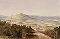
Ōwairaka / Mount Albert in an 1845 watercolour by John Guise Mitford
-
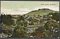
Ōwairaka / Mount Albert in a postcard, from around 1910.
-
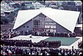
ANZAC Day services at the newly constructed Mount Albert War Memorial in 1961
