
Matukutureia facts for kids
Quick facts for kids Matukutūreia |
|
|---|---|
| McLaughlins Mountain | |

The eastern side of Matukutūreia, with the (now removed) water tank on the summit.
|
|
| Highest point | |
| Elevation | 73 m (240 ft) |
| Geography | |
| Location | North Island, New Zealand |
| Geology | |
| Volcanic arc/belt | Auckland volcanic field |
Matukutūreia is a cool volcanic hill in Auckland, New Zealand. It is also known as McLaughlins Mountain. This hill is 73 metres tall, which is about as high as a 24-story building!
Long ago, Matukutūreia was home to a Māori village called a pā. Today, it's an important part of the Auckland volcanic field.
Contents
What is Matukutūreia?
Matukutūreia is one of many volcanic cones found in the Auckland area. These cones are like small hills formed by ancient volcanoes. This particular hill was once shaped like a crescent moon.
It had special Māori terraces, which are flat steps cut into the hillside. There were also kumara pits, used to store sweet potatoes. These features show that people lived and farmed here a long time ago.
How Matukutūreia Changed
Over time, a lot of Matukutūreia was dug up. This process is called quarrying. People dug up the rock to use for building materials.
Because of this, the hill changed from its crescent shape. It became more like a pyramid. A large water tank was even placed on top to help supply water to the nearby area of Papatoetoe.
What's Left of the Hill?
Luckily, not all of Matukutūreia was quarried away. A small part of the top and the eastern side of the hill are still there. Also, a big area of old lava flows to the south remains untouched.
These remaining parts are very important. They have been given to the Department of Conservation to look after. This is because of the special history of the Matukuturua Stonefields gardens.
Matukurua: Two Hills Together
Matukutūreia and a nearby hill called Wiri Mountain have a special shared name. Together, they are known as Matukurua. Sometimes, they are also called Ngā Matukurua.
The Water Tank Removal
From July to September in 2010, something big happened on Matukutūreia. The large water tank that sat on top of the hill was taken down. This was part of an agreement when the land was given to the Department of Conservation.
It was a big job to remove the tank. Cranes and other equipment were used to carefully take it apart. Now, the top of Matukutūreia looks much more natural.
Images for kids
-
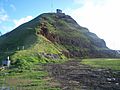
The water tank partly removed.
-
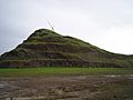
A crane finishing up with the removal.
-
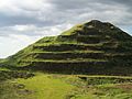
Matukutūreia in its current state.


