Te Tatua-a-Riukiuta facts for kids
Quick facts for kids Te Tātua-a-Riukiuta |
|
|---|---|
| Three Kings | |

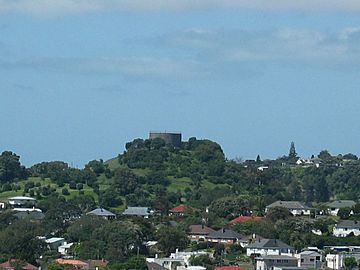
Te Tātua-a-Riukiuta from Mt Albert
|
|
| Highest point | |
| Elevation | 133 m (436 ft) |
| Geography | |
| Location | Auckland, North Island, New Zealand |
| Parent range | Auckland volcanic field |
| Geology | |
| Volcanic arc/belt | Auckland volcanic field |
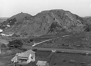
Te Tātua-a-Riukiuta, also known as Three Kings, is a volcano in Three Kings, New Zealand. It erupted a very long time ago, about 28,500 years in the past. This volcano used to have three main peaks and many smaller ones. Over time, most of these peaks were removed by quarrying, which is like digging up rocks and soil for building. Now, only one large peak is left.
Contents
How Te Tātua-a-Riukiuta Formed
Te Tātua-a-Riukiuta was a very interesting volcano in the Auckland volcanic field. It had five big scoria cones and about twelve smaller scoria mounds. Scoria is a type of dark, bubbly volcanic rock. All these cones and mounds sat inside a huge explosion crater. An explosion crater is a big hole left after a powerful volcanic eruption.
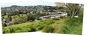
This crater is the largest in Auckland. It is about 800 metres across and nearly 200 metres deep. The initial eruption created this massive hole. You can find Mount Albert Road along the southern edge of the crater and Landscape Road to the north.
The three biggest scoria cones were Big King, which was 133 metres high. East King was 120 metres high, and Highest King reached 135 metres.
Lava Flows and Tunnels
When the volcano erupted, hot lava flowed from it. This lava travelled about three kilometres down a stream valley towards Western Springs. As the lava cooled, it formed lava tunnels underground. These tunnels are like natural pipes.
Today, rainwater that falls on Te Tātua-a-Riukiuta and the nearby areas flows into these underground tunnels. It travels for miles until it comes out at Western Springs Lake. Many of these lava tunnels have collapsed over time. However, some parts still exist as caves. You can sometimes access these caves from private properties in the area.
For a while, people thought the lava from Te Tātua-a-Riukiuta had travelled even further. They believed it formed Meola Reef at Point Chevalier. But in 2008, scientists discovered that the lava for Meola Reef came from an older volcano called Mount Saint John.
When the Volcano Erupted
Scientists have found out that Te Tātua-a-Riukiuta erupted about 28,500 years ago. In 2006, they drilled six boreholes through the lava flows. Inside, they found burnt twigs and wood. By using carbon dating on these old plant pieces, they could tell exactly when the eruption happened. All six samples gave very similar dates, showing the eruption was around 28,500 years ago.
The History of Te Tātua-a-Riukiuta

This volcano has had a few names over time. An older name was Te Tatua o Mataaho. This name referred to a special god who lived in the Maungawhau crater. Later, the name changed to Te Tātua-a-Riukiuta. This new name honours Riukiuta, an important priest from the Tainui waka (canoe). He helped bring together different family lines of the local tribes.
The name "Three Kings" comes from the biblical Magi, also known as the Three Wise Men. Captain William Hobson's surveyor, Felton Mathew, gave it this name in 1841. Big King is the name for the second-highest peak, which is the only one remaining today.
A Historic Pā Site
Te Tātua-a-Riukiuta was once the site of a pā. A pā is a fortified Māori village or settlement. On Big King, you can still see signs of these old Māori earthworks. These include kumara pits (storage areas for sweet potatoes) and terracing on the slopes. Terracing means making flat steps on a hillside, often for growing food or for defence.
Quarrying and Changes to the Volcano
Over many years, the area around Te Tātua-a-Riukiuta has been heavily quarried. This means large amounts of the red scoria rock have been dug up and removed. Because of this, only one of the original three large peaks, Big King, is still standing. It survived mainly because a water reservoir was built on its top in the early 1900s. This reservoir holds water for emergencies, even though it's lower than other water supplies in the area.
Even today, large deposits of scoria in the surrounding area are still being quarried. In 1995, the groundwater level became a problem for the quarry. Winstone Aggregates, the company running the quarry, wanted to supply this water to Auckland City Council. However, local people did not agree with this plan. So, the water is now pumped out and sent into the sea. Pumping out this water, called dewatering, has caused worries about the ground sinking, which is known as subsidence.
Ownership and Co-governance
In 2014, there was a Treaty of Waitangi settlement. This agreement was made with Ngā Mana Whenua o Tāmaki Makaurau, a group of 13 Auckland iwi (Māori tribes). As part of this settlement, the volcano was officially named Te Tātua-a-Riukiuta. Its ownership was given to this group of iwi.
Now, the volcano is managed together by the iwi collective and the Auckland Council. They work together for the benefit of the iwi and all other people living in Auckland.
 | Lonnie Johnson |
 | Granville Woods |
 | Lewis Howard Latimer |
 | James West |


