
Browns Bay, New Zealand facts for kids
Quick facts for kids
Browns Bay
|
|
|---|---|
|
Suburb
|
|

Browns Bay and the beach from above.
|
|

Browns Bay
Location in New Zealand
|
|
| Country | New Zealand |
| Local authority | Auckland |
| Electoral ward | Albany ward |
| Local board | Hibiscus and Bays |
| Area | |
| • Land | 319 ha (788 acre) |
| Population
(June 2023)
|
|
| • Total | 10,700 |
|
|
||
Browns Bay is a lively suburb located on the North Shore in Auckland, New Zealand. It's one of the northernmost parts of the big Auckland city area. The suburb got its name from the Brown family, who settled here in 1876.
Browns Bay started as a popular holiday spot in the late 1800s. Over time, it grew into a busy suburb, especially in the 1950s. For a while, from 1975 to 1989, it was the main office for the East Coast Bays City council. In the 1990s, Browns Bay became a special place for many South African New Zealander families.
Contents
Exploring Browns Bay's Location

Browns Bay is part of the beautiful East Coast Bays area on the North Shore. It sits between two other bays, Waiake to the north and Rothesay Bay to the south. From the beach, you can see islands in the Hauraki Gulf, like Rangitoto, Motutapu Island, and Rakino Island.
A small stream called the Taiaotea Creek flows through Browns Bay. It empties into the Hauraki Gulf. The land here is mostly made of clay and a type of sandstone. You can see this rock in the cliffs along the coast.
Before people settled here, Browns Bay was covered in thick native forests. These forests had huge trees like tōtara, mataī, miro, kauri, and kahikatea. Along the coastline, beautiful pōhutukawa trees were common. By the 1870s, much of the forest had been cleared. The area then had lots of scrub, including mānuka and tutu plants.
Browns Bay Through Time
Early Māori History
Māori people first settled in the Auckland Region a long time ago, around the 1200s or 1300s. The North Shore was home to Tāmaki Māori tribes. These groups included people connected to the Tainui canoe.
Browns Bay didn't have the best soil for farming. However, Māori used the area for fishing, gathering shellfish, and hunting birds. One old Māori name for the creek here is Taiaotea, which means "Clear Environment."
Around the 1600s, a warrior named Maki came to the Auckland area. He united many Tāmaki Māori tribes, forming Te Kawerau ā Maki. After Maki, his sons and daughter Kahu continued to lead. Kahu is so important that the North Shore is sometimes called Te Whenua Roa o Kahu, meaning "The Greater Lands of Kahu."
Later, in the 1700s, the Marutūāhu tribe Ngāti Paoa became powerful in the Hauraki Gulf and North Shore. A defensive fort, or pā, called Ōmangaia Pā, was located near Browns Bay. It was used by a chief named Te Hehewa. By the late 1700s, there was peace in the area.
Europeans started arriving in the late 1700s. This brought new diseases, which sadly affected many Māori. In the early 1820s, many Māori left the North Shore. They moved to Waikato or Northland to avoid wars. Most people returned by the late 1820s and 1830s.
European Settlers Arrive
.jpg)
.jpg)
In 1841, the Crown bought a large area of land. This land stretched from Takapuna to Te Ārai. Some Māori tribes agreed to the sale, but others who also had rights to the land did not. The government worked until 1873 to fix these land deals.
The first European to own land in Browns Bay was John Logan Campbell. He bought land in 1864, hoping to find coal. When he didn't find any, he sold the land in the 1870s. During this time, Māori from Whangaparāoa would camp at Browns Bay. They grew crops like melons, potatoes, and kūmara on the hills.
In 1876, Peter Brown bought 136 acres of land. He settled there with his family and cleared the scrubland. The Brown family started a dairy farm. They also had orchards, a vineyard, and kept bees. They grew crops like carrots. The suburb was named after Peter Brown.
The Brown family also ran a guest house in the 1880s. Holidaymakers would visit the beach and stay there. Roads to Browns Bay were rough clay tracks. So, most visitors arrived by ferry boat. Browns Bay became very popular in summer, but not many people lived there permanently. The first school opened in 1888.
The area grew more in the early 1900s. A new wharf was built, roads improved, and a tram line reached nearby Milford. The Taiotea Boating Club started around 1902. It was the first boating club in the East Coast Bays.
In 1916, the Brown family divided their farm into smaller sections. By 1919, holiday homes were being built. A post office opened in 1919, called Taiaotea. In 1926, the area was officially named Browns Bay.
Even though it was hard to get to, Browns Bay became the main gathering place for the East Coast Bays communities. In 1925, the 555 Cabaret and Cinema opened. This club was very popular with boaters and holidaymakers. For a while, people even called the area "Naughty Bay" because it was so lively. Browns Bay stayed popular for holidays and camping into the 1930s and 1940s.
In 1936, a big storm damaged the wharf and other buildings. The wharf was never rebuilt. During the Great Depression in the 1930s, a government work program helped improve the roads. This helped Browns Bay grow after World War II. During the war, machine gun posts and wire fences were built along the beach for defence. Small concrete shelters, called pillboxes, were also built.
Browns Bay Becomes a Suburb
By the late 1950s, Browns Bay changed from a holiday spot to a proper suburb of Auckland. This happened after the Auckland Harbour Bridge was built, making travel easier. By 1945, ten shops were open in Browns Bay. In 1946, Freyberg Park opened for local sports. In the 1950s, a roller skating rink also became a popular attraction.
Manufacturing businesses started in Browns Bay in the early 1950s. One made concrete roof tiles using local sand. Another was a clothing company called Ambler & Co. Also in the 1950s, Browns Bay became a centre for building and fixing boats. Famous boat designer John Spencer set up his workshop here. He created new ways to build light boats and yachts.
Browns Bay was the main town for the East Coast Bays area. In the early 1970s, new council buildings were built. In 1975, the area officially became East Coast Bays City.
In the early 1990s, the Browns Bay Mall opened. The popular New Zealand TV show Shortland Street also started filming in the suburb in 1992. In the early 2000s, the council improved the beachfront with a new walkway.
Browns Bay became a special place for the South African New Zealander community in the 1990s. By 2003, Afrikaans was the second most spoken language in the suburb.
Things to Do in Browns Bay
- Freyberg Park opened in 1946. It's a sports ground named after Bernard Freyberg, a famous New Zealand soldier and Governor-General.
- The Browns Bay Beach Reserve is a park next to the beach. It has the only skatepark in the East Coast Bays. A popular walking path connects Browns Bay to Campbells Bay from here.
- The Stone of Remembrance is a memorial for ANZAC soldiers. It's on the Browns Bay waterfront and was put there in 1968.
- Sherwood Reserve is a wetland park developed in the 1970s. It's known for its fun Robin Hood-themed playground.
- The Village Green is a central park in Browns Bay. It was also developed in the 1970s.
Sports and Fun
- The East Coast Bays Barracudas rugby league club is based in Browns Bay.
- The Browns Bay Bowling Club has been operating in the suburb since 1943.
Who Lives in Browns Bay?
Browns Bay covers about 3.19 square kilometres. As of June 2023, an estimated 10700 people live here.
In 2018, Browns Bay had a population of 9,996 people. This was an increase of 567 people since 2013. About 18% of the people living here were under 15 years old.
The community in Browns Bay is very diverse. About 68.6% of people are European/Pākehā. Around 4.9% are Māori, and 27.6% are Asian. Many people (52.7%) were born outside New Zealand.
When asked about religion, 53.9% said they had no religion. About 34.8% were Christian. Other religions like Hindu, Muslim, and Buddhist were also present.
Many adults in Browns Bay have a university degree (31.3%). About 51.5% of people aged 15 and over work full-time.
Learning in Browns Bay
Browns Bay has a primary school called Browns Bay School. It teaches students from Year 1 to Year 6. The school first opened its doors in 1888.
Harbour College is a Montessori school in Browns Bay. It teaches students from Year 7 to Year 10.
The Corelli International Academic School of the Arts used to be in Browns Bay. It was a private school that focused on visual arts, music, drama, and dance. It opened in 2001 but later closed down.
Famous People from Browns Bay
- Ryk Hattingh: A South African writer and journalist.
- Michael King: A well-known New Zealand historian.
- Jelal Kalyanji Natali: An Indian-New Zealand shopkeeper and community leader. He was also an anti-racism activist.
- John Spencer: A famous New Zealand boat designer.
Images for kids
-
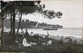
Picnickers at Browns Bay in the 1910s, with the Browns Bay Wharf and the SS Taniwha
