Milford, New Zealand facts for kids
Quick facts for kids
Milford
|
|
|---|---|
|
Suburb
|
|
Milford Marina
|
|
| Country | New Zealand |
| Local authority | Auckland |
| Electoral ward | North Shore ward |
| Local board | Devonport-Takapuna Local Board |
| Area | |
| • Land | 153 ha (378 acre) |
| Population
(June 2023)
|
|
| • Total | 5,020 |
| Postcode(s) |
0620
|
|
|
||
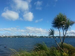
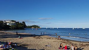
Milford is a lovely suburb found on the North Shore in Auckland, New Zealand. It sits on the northern side of Lake Pupuke, a cool freshwater lake. Milford is also famous for its popular swimming beach, which stretches for about two kilometers.
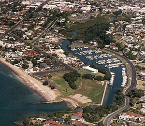
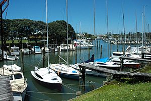
At the northern end of Milford Beach, the Wairau Creek flows into the Hauraki Gulf. This is where you'll find the Milford Marina, a place for boats.
Contents
Milford's Name: Where Did It Come From?
The name "Milford" started appearing around 1892 for Milford Road and 1894 for Milford Beach. The area became known as Milford as a suburb around 1912.
The name is linked to an early resident named Edwin Harrow, who moved here in 1881. It might come from "Milford House," one of his homes near Lake Pupuke. Or, it could be named after his hometown, Milford Haven in Wales.
Milford's Ancient Landscape: Rocks and Volcanoes
The North Shore area is mostly made of Waitemata Group sandstone. This rock formed on the sea floor millions of years ago, between 22 and 16 million years ago.
Milford is home to Lake Pupuke, which is a special type of volcanic lake called a maar. It's one of the oldest volcanoes in the Auckland volcanic field, erupting about 193,200 years ago.
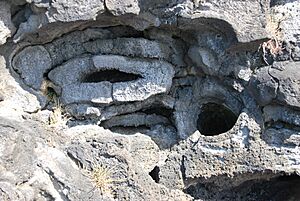
During Lake Pupuke's eruption, hot lava flowed through the area. This lava burned plants and covered the bottom parts of tree trunks. When the lava cooled, it turned into hard rock called basalt. This created the amazing Takapuna Fossil Forest. About 7,000 years ago, the sea wore away the land, revealing these ancient tree trunks.
Before people settled here, the coast was covered in pōhutukawa trees. Inland, there were large forests with kauri trees. Southwest of Milford, you can still find a piece of this old forest called Smiths Bush. It has tall kahikatea and taraire trees.
Milford's Location and Natural Features
Milford is located on the northern side of Lake Pupuke. To the west of Milford Beach, you'll find a rock formation called Black Rock.
Milford is surrounded by other suburbs like Takapuna, Wairau Valley, Forrest Hill, and Castor Bay. The Wairau Creek flows through the North Shore and empties into the Rangitoto Channel of the Hauraki Gulf at Milford. The highest point in Milford is about 49 meters above sea level.
Milford's Past: A Journey Through Time
Māori History in Milford
Māori people first settled in the Auckland Region around the 13th or 14th centuries. The Devonport-Takapuna area was one of the first places they lived. An important ancestor named Peretū settled here.
Milford Beach was traditionally known as Onemaewao, which means "The Beach of Maewao." Maewao were supernatural beings from old stories.
Later, a warrior named Maki came to the Auckland Region in the 17th century. He united many local tribes, forming Te Kawerau ā Maki. After Maki died, his son Maraeariki settled the North Shore. His daughter Kahu then became a leader, and the North Shore is sometimes called Te Whenua Roa o Kahu ("The Greater Lands of Kahu") after her.
There was once a defensive fort, called a pā, at Wairoa Pā. This pā was located on the headland above Milford Beach, north of the Wairau Creek mouth.
In the 17th century, the Ngāti Pāoa tribe attacked settlements around the Waitematā Harbour. Later, many Māori people left the North Shore in the early 1820s because of wars during the Musket Wars.
Early European Settlers in Milford
The New Zealand government bought the Milford area in 1841. The first European farmers arrived in 1847. These early settlers were mostly from England, Scotland, and Ireland. They started farms around Lake Pupuke, growing crops like wheat, corn, and potatoes. They also planted orchards with fruit trees.
Milford was first known as Campbell's Bush, named after John Logan Campbell. He owned a lot of land on the North Shore.
By the late 1880s, Takapuna and Lake Pupuke became popular places for tourists. Farmers started selling parts of their land. A hotel was built, and wealthy business people built large summer homes near the lake. Many of them eventually moved here permanently, traveling to Auckland by ferry for work.
A man named James Sheriff ran a kauri gum store in Milford. This made Milford a trading spot where goods were exchanged between Auckland and the local farms.
Milford's Growth: From Rural to Suburb
In 1910, a private tramway (like a small train on tracks) was built. It took passengers from Milford to the ferry at Bayswater. This tramway helped property prices go up and led to fast growth in Takapuna. The tramway closed in 1927, but it had already helped turn Milford from a rural area into a holiday spot. A tall footbridge was also built over the Wairau Creek, connecting Milford to Castor Bay.
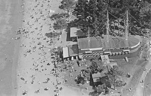
By the 1920s, Milford was a fun place for entertainment. Two cinemas opened in 1922. In 1929, a unique dance hall and restaurant called "Ye Olde Pirate Shippe" opened. It was designed to look like a pirate ship and was very popular. A swimming pool opened in 1936. During World War II, American soldiers often visited the pirate ship. After the war, Milford became less of a tourist spot. The pirate ship was taken down in the 1950s, and the pools were removed in 1957.
In the 1920s, a quarry in Milford dug up volcanic rock. The first concrete road was built between Milford and Bayswater.
The Auckland Harbour Bridge opened in 1959, connecting the North Shore to Auckland City. This caused Milford to grow even more, changing it from a holiday community to a place where people lived all year round. In 1968, the Milford Marina was built at the mouth of the Wairau Creek. The old footbridge was taken down two years later. In 1975, the marina was made bigger, which helped a boating industry grow in Milford.
In December 1994, the Milford Shopping Centre opened. It's a large shopping center with many stores and parking spaces. In December 2015, a new pedestrian bridge was opened over the Wairau Stream.
Milford's Community: People and Diversity
Milford covers about 1.53 square kilometers. As of 2023, it has an estimated population of about 4,929 people.
In the 2023 census, there were slightly more females than males. About 15% of people were under 15 years old, and about 25% were 65 or older.
Most people in Milford are of European background (71.3%). There are also significant Asian (25.8%), Māori (5.1%), and other ethnic groups. English is the main language spoken, but many other languages are also used. About 40.9% of people were born outside New Zealand.
Many people in Milford have higher education degrees. About 47% of people aged 15 and over work full-time.
Famous People from Milford
- C. F. Goldie – a well-known artist
- Harry Lyon – a musician from the band Hello Sailor
- Dave McArtney – a musician from Hello Sailor and the Pink Flamingos
- Don McGlashan – a musician from the bands Blam Blam Blam and The Mutton Birds
Fun Places and Services in Milford
- Milford Beach is one of the most popular beaches on the North Shore. The Milford Surf Life Saving Club was formed in 1926 to help keep swimmers safe.
- Milford Marina is a place where boats are docked, located in the Wairau Creek estuary. It was built in the 1960s.
- Milford Reserve is a public park. It's where the old pirate ship dance hall used to be. It's also home to the Milford Cruising Club and a sculpture called Beacon.
- Lake Pupuke is a freshwater lake between Milford and Takapuna. Sylvan Park, a nature reserve, is a great place to see native trees like karaka and pūriri. The lake is popular for sailing and rowing.
- Brian Byrnes Reserve is where the Milford Bowling Club is located.
- Milford Centre is a large shopping center with many stores.
- St Paul's Anglican Church Milford, Milford Baptist Church, and Saint Vincent de Paul Church are places of worship in Milford.
Schools in Milford
- Carmel College is a Catholic secondary school for girls (Years 7-13). It was founded in 1957.
- Milford School is a primary school for boys and girls (Years 1-6). It opened in 1926.
Rolls are as of February 2024. .
 | Bayard Rustin |
 | Jeannette Carter |
 | Jeremiah A. Brown |


