North Head (New Zealand) facts for kids
Quick facts for kids North Head |
|
|---|---|
| Maungauika / North Head | |

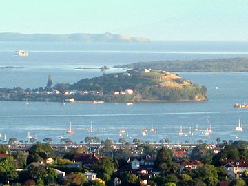
North Head with the flanks of Rangitoto Island and the Hauraki Gulf beyond
|
|
| Highest point | |
| Elevation | 50 m (160 ft) |
| Naming | |
| Native name | Error {{native name}}: an IETF language tag as parameter {{{1}}} is required (help) |
| Geography | |
| Location | North Island, New Zealand |
| Geology | |
| Volcanic arc/belt | Auckland volcanic field |

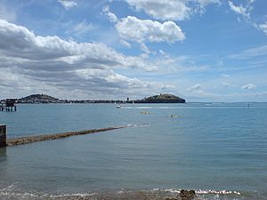
Maungauika / North Head is a special volcano and ancestral mountain (called a Tūpuna Maunga) in Auckland, New Zealand. It sits at the eastern end of the Waitematā Harbour in the suburb of Devonport. This spot is famous for its amazing views of the harbour and the Hauraki Gulf. For many years, starting in 1885, the military used Maungauika as a defence base. They built a network of old bunkers and tunnels, which are now a fun part of visiting the site.
In 1972, Maungauika became part of the Hauraki Gulf Maritime Park. It was also listed as a very important historic place in 2001. In 2014, as part of a Treaty of Waitangi agreement, the volcano was officially named Maungauika. The reserve is now also known as Maungauika / North Head Historic Reserve.
Contents
What's in a Name?
The name Maungauika comes from the Māori language. It means "The Mountain of Uika." Uika was a Tāmaki Māori ancestor who is believed to have lived there about 800 years ago. The name North Head simply describes its location. It's at the northern entrance to the Waitematā Harbour.
A Journey Through Time: History of Maungauika
The shape of the volcano has changed a lot over time. First, the ocean wore it down. Later, different groups of people who lived there changed it too.
Early Māori Life on the Mountain
The first people to use Maungauika were the Māori. It is said that the Tainui canoe landed nearby at what is now Torpedo Bay. The Tainui people named a spring 'Takapuna'. This name was later used for the nearby beach.
Old photos show that Māori grew gardens on the lower parts of the hill. However, there don't seem to be any pā (fortifications) like on other volcanoes in the area. European visitors in the 1850s also saw a settlement at the bottom of the hill. It had gardens and racks for drying fish.
Protecting Auckland: Military Forts
North Head was first used to guide ships into Auckland's harbour. In 1878, it became a public park. But there was a rule: the New Zealand Army could take it over for defence if needed. This happened in 1885. There was a fear of a Russian attack, so forts were quickly built around Auckland.
The defences at Maungauika had three gun batteries:
- North Battery faced the Rangitoto Channel.
- South Battery faced the inner harbour.
- Summit/Cautley Battery was at the top of the hill.
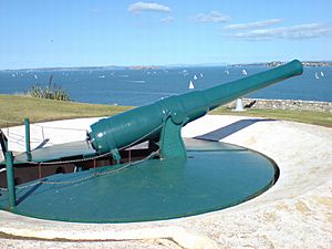
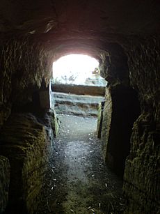
These first forts were built quickly. Over the next 25 years, they were made stronger and bigger. Prisoners helped build them, adding many tunnels, underground storage rooms, and observation posts. The fort had powerful guns, including "disappearing guns" that could pop up to fire and then hide again. There were also searchlights and a minefield in the harbour.
None of these weapons were ever used in a real battle. However, a special group of four guns was used to fire salutes. For example, they saluted Queen Elizabeth II when she visited in 1953.
In the 1930s, parts of the fort were updated. During World War II, Maungauika became the main office for Auckland's coast defences. The buildings from that time are still there today. The coastal defences were removed in 1950. One disappearing gun was left behind because it was too hard to take apart. After the army left, the area became a park again. The New Zealand Navy kept a small area at the top for a training school until 1996.
Exploring Maungauika Today
Since 1996, the Department of Conservation has looked after Maungauika as a reserve. It's a great place for walks along the water or up to the summit. From the top, you get amazing views of Rangitoto Island and Auckland.
Many people enjoy exploring the old gun positions and the tunnel system. A large part of the tunnels is open to the public. Remember to bring a torch if you want to explore them!
In the late 1980s, there were stories about strange smells and secret caves under the hill. Some even said there were hidden aeroplanes! People worried that old ammunition might be decaying. So, a big investigation started. They looked at old documents, did geological tests, and dug in many places. But they didn't find much new or dangerous.
Sharing the Land: Treaty Settlement
In 2014, an agreement was made between the Crown (the New Zealand government) and a group of 13 Auckland iwi and hapu (Māori tribes and sub-tribes). This group is called Ngā Mana Whenua o Tāmaki Makaurau or the Tāmaki Collective.
As part of this Treaty of Waitangi agreement, the ownership of 14 ancestral mountains (Tūpuna Maunga) in Auckland was given to the Tāmaki Collective. Maungauika was one of these mountains. The law says that the land is held "for the common benefit" of the Māori groups and all other people of Auckland.
A special group called the Tūpuna Maunga o Tāmaki Makaurau Authority (TMA) was created. This group works together with the Auckland Council to manage all 14 Tūpuna Maunga, including Maungauika.
 | Kyle Baker |
 | Joseph Yoakum |
 | Laura Wheeler Waring |
 | Henry Ossawa Tanner |


