
Glenfield, New Zealand facts for kids
Quick facts for kids
Glenfield
|
|
|---|---|
|
Suburb
|
|

The front top parking lot at Glenfield Mall. Most of the parking, and most of the mall itself, is behind and below on further levels. (Photo taken prior to overhaul in the mid-2010s)
|
|

Glenfield
Location in New Zealand
|
|
| Country | New Zealand |
| Local authority | Auckland |
| Electoral ward | North Shore Ward |
| Local board | Kaipātiki Local Board |
| Area | |
| • Land | 472 ha (1,166 acre) |
| Population
(June 2023)
|
|
| • Total | 17,630 |
| Postcode(s) |
0629
|
|
|
||
Glenfield (Māori: Te Wairau) is a suburb in Auckland, New Zealand. It is located on the North Shore. In the 1850s, Glenfield started as a small farming community. It grew into a busy suburban area after the Auckland Harbour Bridge opened in 1959.
Contents
What's in a Name? The Story of Glenfield

The name Mayfield was first used for this area in the late 1800s. Before that, it was seen as part of nearby places like Takapuna. A landowner named R. Arthur used "Mayfield" in an advertisement in 1883.
Local people liked the name. They adopted it for their school and the area in 1890. They thought the white mānuka bushes looked like springtime in England, which is often in May.
In 1912, residents asked the post office to change the name to Glenfield. The post office had been using "Freemans" since 1888. This name came from John Freeman, who ran the post office from his home. The post office didn't want to use Mayfield because it could be confused with Mayfield in the Canterbury Region.
An older Māori name for the area is Opuawananga. This name refers to puawānanga, a native clematis flower. This name was used for a bush area on the North Shore where these flowers grew. Today, Glenfield College uses the name Te Puawānanga for its special meeting house.
Glenfield's Location and Landscape
Glenfield is a suburb on the North Shore of New Zealand. It sits between the Kaipātiki Creek and the Wairau Valley. The Kaipātiki Creek flows into Oruamo or Hellyers Creek.
The highest point in Glenfield is a hill between Colin Wild Place and Chivalry Road. It is about 83 meters (272 feet) above sea level. The land is mostly made of sandstone and mudstone.
Long ago, Glenfield was covered in kauri and other native forests. By the 1800s, much of it had become scrubland with lots of mānuka bushes.
Some areas within Glenfield have their own names. Marlborough is in the south-east. It grew into a suburban area in the 1960s and 1970s. Glenfield North is another part of the suburb.
A Look Back: Glenfield's History
Māori Life in Glenfield

Māori people first settled in the Auckland Region around the 1200s or 1300s. The North Shore was home to Tāmaki Māori tribes.
The clay soils in Glenfield were not good for traditional Māori gardening. So, this area was not as heavily settled as other parts of the North Shore. However, the forests here were important for gathering berries.
Archaeologists have found old shell piles, called middens, along the Kaipātiki Creek. These show that Māori people used to gather food there. Manuka Road was once an ara, which means a traditional path. It connected Oruamo or Hellyers Creek to the central North Shore.
A warrior named Maki came to the Auckland Region in the 1600s. He united many Tāmaki Māori tribes, forming Te Kawerau ā Maki. After Maki, his children settled different areas. His son Maraeariki settled the North Shore. Maraeariki's daughter, Kahu, is the namesake of the North Shore. Its Māori name is Te Whenua Roa o Kahu, meaning "The Greater Lands of Kahu."
In the early 1820s, many Māori left the North Shore. This was due to wars during the Musket Wars. When they returned in the 1830s, Te Kawerau ā Maki mainly settled at Te Henga / Bethells Beach.
Early European Settlers Arrive
_(cropped).jpg)
One of the first land sales to Europeans in Auckland happened near Glenfield in 1837. Ngāti Whātua chiefs sold a large piece of land to William Webster. He then sold it to Thomas Hellyer in 1840. Hellyer built a house called the Retreat. It had a sawpit for cutting kauri timber. Sailors often stopped there for fresh water. In 1841, Hellyer's body was found, but no one was ever charged.
In the 1850s, the first European families settled in Glenfield. They started orchards and dairy farms. People also worked as gum diggers from 1859 to the 1920s. Gum diggers would sometimes burn the mānuka scrub to find kauri gum more easily.
Windy Ridge was one of the first inland areas settled by Europeans. Terence and Elizabeth Crook bought a large piece of land there.
Growing as a Rural Community
_(cropped).jpg)
In the late 1800s and early 1900s, Glenfield was connected to the outside world by rough tracks. Farmers took their fruit and produce by horse carriage to Northcote and Birkenhead. From there, ferries carried goods to Auckland markets.
Glenfield began to grow around Mayfield Road in the 1880s. This happened after roads were improved in 1885. By 1889, many cottages were built. A kauri gum store opened in the 1890s. Dairy farms in Glenfield supplied milk and cream to Auckland.
The first post office opened in 1888. In 1890, a health retreat called the New Zealand Hydropathic and Fruit Hospital opened. It offered treatments like special diets and baths.
Mayfield School opened in 1891 and became a social hub. In 1912, the area was officially renamed Glenfield. This was to avoid confusion with another Mayfield.
On September 4, 1915, the community built Mission Hall in just one day. This hall was used by different Christian groups. By the 1920s, the first store opened on Glenfield Road. Two brickworks also started, but they closed in the 1930s. Cars became more common than horses for transport by the late 1920s.
In the 1920s, a local farmer named James Mackay found a new type of strawberry. It was called the Captain Cook strawberry. This smaller, sweeter strawberry became very popular in Auckland for many years.
The Glenfield War Memorial Hall was built in 1934. It hosted important community events, like dances.
Becoming a Modern Suburb

The opening of the Auckland Harbour Bridge in 1959 changed Glenfield quickly. The population grew from about 5,600 people in 1961 to over 13,000 by 1966. Most of the suburb was developed in the 1960s.
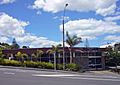
In 1971, Glenfield Mall opened. It was the first shopping mall on the North Shore. This helped to keep shops from spreading too far along Glenfield Road. The Glenfield Library was built in 1975.
In 2000, Glenfield Mall was updated to be a more modern shopping center.
Famous Faces from Glenfield
- James K. Baxter: A well-known author and poet. He passed away in Glenfield in October 1972.
- Janet Frame: An author who lived in Glenfield in the 1970s.
- Rachel Hunter: A famous model who grew up in Glenfield.
Places to Visit and Things to Do
- Southern Cross Hospital North Harbour: A private hospital on Wairau Road.
- Agincourt Reserve: Home to the Marlborough Kindergarten and the North Shore Woodturners Guild.
- Marlborough Park: A local park with playgrounds and a tennis club. It also has the Marlborough Park Skate Park, which opened in 2020. The Kaipātiki Community Trust is also based here.
Schools and Learning
Glenfield has several schools:
- Glenfield College: A high school for students in years 9–13.
- Glenfield Intermediate: For students in years 7–8.
- Glenfield Primary School: For younger students in years 1–6.
- Marlborough Primary School: Also for years 1–6.
- Windy Ridge School: A primary school for years 1–6. It also has special classes for students with disabilities from Wilson School.
All these schools are for both boys and girls. The South Seas Film, Television, and Animation school is also located in Glenfield.
Sports Teams
Glenfield is home to several sports clubs:
- Glenfield RFC: A rugby club that is part of the North Harbour Rugby Union.
- Glenfield Rovers: A football (soccer) club that plays in the Lotto Sport Italia NRFL Division 1B.
- The Glenfield Greyhounds: A rugby league club based nearby in Sunnynook.
Who Lives in Glenfield? (Demographics)
Glenfield covers an area of about 4.72 square kilometers (1.82 square miles). As of 2023, it has an estimated population of around 16,900 people.
In 2018, there were 16,872 people living in Glenfield. This was an increase of about 9.5% since 2013. There were slightly more females than males. About 17% of the people were under 15 years old.
The people in Glenfield come from many different backgrounds:
- About 43% are European/Pākehā.
- About 7% are Māori.
- About 5% are Pasifika.
- About 49% are Asian.
- About 5% are from other ethnic groups.
Many people in Glenfield were born outside New Zealand (about 55%). This is higher than the national average of 27%.
When it comes to religion, about 43% of people said they had no religion. About 40% were Christian. Other religions like Hindu, Muslim, and Buddhist were also present.
About 32% of people aged 15 or older had a university degree or higher. Most people aged 15 or older were employed, with about 54% working full-time.
Images for kids
-
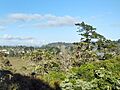
Archaeological middens have been found on the shores of the Kaipātiki Creek
-
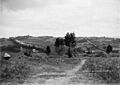
View of rural Glenfield circa 1915
-
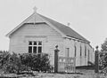
Glenfield Mission Hall, which was constructed in a day on 4 September 1915
-
Glenfield Public Library was constructed in 1975
