
Canterbury Region facts for kids
Quick facts for kids
Canterbury
Waitaha (Māori)
|
|
|---|---|
|
Region
|
|
 Canterbury Region in New Zealand
|
|
| Country | New Zealand |
| Island | South Island |
| Established | 1989 |
| Seat | Christchurch |
| Territorial authorities |
List
Kaikōura District
Hurunui District Selwyn District Waimakariri District Christchurch City Ashburton District Mackenzie District Timaru District Waimate District Waitaki District (59.61%) |
| Government | |
| • Body | Canterbury Regional Council |
| Area | |
| • Land | 44,503.60 km2 (17,182.94 sq mi) |
| Population
(June 2023)
|
|
| • Region | 666,300 |
| Demonym(s) | Cantabrian |
| GDP | |
| • Total | NZ$44.032 billion (2021) (2nd) |
| • Per capita | NZ$67,400 (2021) |
| Time zone | UTC+12 (NZST) |
| • Summer (DST) | UTC+13 (NZDT) |
| ISO 3166 code | NZ-CAN |
| HDI (2022) | 0.943 very high · 3rd |

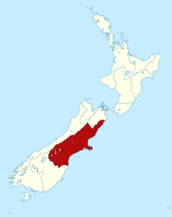
Canterbury (Māori: Waitaha) is a large region in the central-eastern South Island of New Zealand. It covers about 44,500 square kilometers, making it the biggest region in the country by land area. As of July 2025, it is home to over 650,000 people.
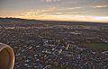
The region as we know it today was created in 1989. Christchurch, the largest city in the South Island, is the main center of Canterbury. Most of the region's people live there. Other important towns include Timaru, Ashburton, Rangiora, and Rolleston.
Contents
History of Canterbury
Natural History
Canterbury's land, water, plants, and animals have a very long history. It started with the formation of the greywacke rocks that make up the Southern Alps. This history is connected to how tectonic plates moved and formed, leading to oceans and then life itself.
The region is part of the larger Zealandia continent. This land was shaped by powerful forces where tectonic plates meet. Over time, rain, snow, ice, and rocks grinding together created huge gravel plains stretching from the mountains. There are also volcanoes that pushed through the older rocks. On this strong foundation, unique plants and animals slowly developed over billions of years. You can still see some of these special species in protected areas today.
Early Māori Settlement
Canterbury has been home to different Māori people groups for many centuries. When European settlers arrived, the Ngāi Tahu people lived there. Their numbers had been greatly reduced by wars, both among themselves and with other tribes from the North Island in the early 1800s.
European Colonisation
In 1848, Edward Gibbon Wakefield and John Robert Godley started the Canterbury Association. Their goal was to create an Anglican colony in the South Island. They managed to raise enough money and attract settlers from middle and upper-class families.
In April 1850, a first group led by Godley landed at Port Cooper, which is now Lyttelton Harbour / Whakaraupō. They set up a port, houses, and shops for the main group of settlers. In December 1850, the first 750 settlers arrived in Lyttelton on four ships.
After 1850, the region's economy grew with the introduction of sheep farming. Canterbury's wide, grassy plains were perfect for raising many sheep. Settlers valued sheep for their meat and wool. By the early 1850s, there were over half a million sheep in the region. This number grew to three million by the 1860s.
Canterbury Province
The Canterbury Province was created in 1853. It covered the middle part of the South Island, from the east coast to the west coast. This province was later ended in 1876, along with other provinces in New Zealand. The Canterbury Region we know today has slightly different borders.
Earthquakes of 2010–2011
Canterbury experienced a series of strong earthquakes that caused significant damage.
September 2010 Earthquake

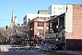
A powerful magnitude 7.1 earthquake hit the region on September 4, 2010, at 4:35 AM. Its center was about 40 kilometers west of Christchurch. The earthquake caused widespread damage to buildings and power outages. Luckily, no one died directly from this quake. However, sewers, gas, and water lines were broken. Power was cut to about 75% of Christchurch. Many chimneys fell through roofs, and brick walls collapsed.
A local state of emergency was declared. The city center was closed, and a curfew was put in place. The New Zealand Army helped police enforce the curfew. There were many aftershocks, with some being quite strong. The total cost of the damage was estimated to be up to $11 billion.
February 2011 Earthquake

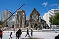
A major aftershock, with a magnitude of 6.3, struck on February 22, 2011, at 12:51 PM. It was centered just north of Lyttelton, about 10 kilometers southeast of Christchurch. Even though it was a lower magnitude than the 2010 quake, the shaking was extremely strong. This was because it was very shallow and close to the city center.
This quake happened on a busy weekday afternoon. Because of its strength and location, 181 people died. Many buildings and famous landmarks were badly damaged, including the ChristChurch Cathedral. New Zealand declared its first National State of Emergency after this event.
June 2011 Earthquake
On June 13, 2011, Christchurch was hit by another magnitude 5.7 quake, followed by a magnitude 6.3 quake later that afternoon. These quakes were centered in a similar spot to the February quake. More aftershocks followed in the next few days.
Phone lines and power were lost in some areas. Liquefaction, where the ground acts like a liquid, happened in eastern parts of the city. Many buildings in the city center were further damaged, with about 75 more needing to be torn down. The Christchurch Cathedral lost its famous rose window. One person died, and many were injured.
Geography
The Canterbury Region includes all the river areas on the east coast of the South Island. It stretches from the Waiau Toa / Clarence River in the north to the Waitaki River in the south. It is New Zealand's largest region by area, covering over 45,300 square kilometers.
Canterbury is often divided into different parts:
- North Canterbury: North of the Rakaia River to the Conway River.
- Mid Canterbury: From the Rakaia River to the Rangitata River.
- South Canterbury: South of the Rangitata River to the Waitaki River.
- Christchurch City: The main urban area.
Climate
Canterbury has a varied climate. The weather can change depending on how close you are to the coast or the mountains.
| Climate data for Canterbury | |||||||||||||
|---|---|---|---|---|---|---|---|---|---|---|---|---|---|
| Month | Jan | Feb | Mar | Apr | May | Jun | Jul | Aug | Sep | Oct | Nov | Dec | Year |
| Record high °C (°F) | 40.2 (104.4) |
42.4 (108.3) |
36.0 (96.8) |
30.2 (86.4) |
29.7 (85.5) |
24.8 (76.6) |
24.1 (75.4) |
26.3 (79.3) |
30.0 (86.0) |
32.0 (89.6) |
36.2 (97.2) |
36.1 (97.0) |
42.4 (108.3) |
| Mean daily maximum °C (°F) | 21.7 (71.1) |
21.4 (70.5) |
19.5 (67.1) |
16.5 (61.7) |
13.1 (55.6) |
10.3 (50.5) |
9.5 (49.1) |
11.0 (51.8) |
13.8 (56.8) |
15.9 (60.6) |
17.9 (64.2) |
19.9 (67.8) |
15.9 (60.6) |
| Daily mean °C (°F) | 16.0 (60.8) |
15.8 (60.4) |
14.0 (57.2) |
11.1 (52.0) |
8.1 (46.6) |
5.5 (41.9) |
4.8 (40.6) |
6.2 (43.2) |
8.5 (47.3) |
10.5 (50.9) |
12.4 (54.3) |
14.5 (58.1) |
10.6 (51.1) |
| Mean daily minimum °C (°F) | 10.3 (50.5) |
10.2 (50.4) |
8.6 (47.5) |
5.8 (42.4) |
3.2 (37.8) |
0.8 (33.4) |
0.2 (32.4) |
1.4 (34.5) |
3.3 (37.9) |
5.2 (41.4) |
7.0 (44.6) |
9.1 (48.4) |
5.4 (41.7) |
| Record low °C (°F) | −2.3 (27.9) |
−0.8 (30.6) |
−4.4 (24.1) |
−5.3 (22.5) |
−7.2 (19.0) |
−21.0 (−5.8) |
−21.0 (−5.8) |
−11.4 (11.5) |
−8.0 (17.6) |
−7.6 (18.3) |
−5.9 (21.4) |
−4.2 (24.4) |
−21.0 (−5.8) |
| Source: Weatherbase | |||||||||||||
People and Culture
Canterbury Region covers about 44,500 square kilometers. Statistics New Zealand estimated the population of Canterbury to be 651,027 people in the 2023 census. This means there are about 14.6 people per square kilometer. Canterbury is home to about 12.7% of New Zealand's total population.
In the 2023 census, the population had grown by 8.6% since 2018. The median age was 39.1 years. About 17.5% of people were under 15 years old, and 17.4% were 65 or older.
Urban Areas
The largest urban areas in Canterbury include:
Culture and Identity
People in Canterbury come from many different backgrounds. In the 2023 census:
- 80.3% identified as European (Pākehā).
- 10.6% identified as Māori.
- 3.7% identified as Pasifika.
- 13.3% identified as Asian.
- 1.6% identified as Middle Eastern, Latin American, and African.
- 2.5% identified as other ethnicities.
English is spoken by most people (96.3%). Other languages spoken include Māori (2.1%) and Samoan (1.0%). About 24.6% of people were born overseas.

When it comes to religion, 32.2% of people identified as Christian. The largest Christian groups are Anglicanism (14.8%) and Catholicism (12.7%). Many people (55.1%) said they had no religion.
Economy

The total value of goods and services produced in Canterbury, called gross domestic product (GDP), was estimated at NZ$44.2 billion in the year ending March 2022. This was about 12.4% of New Zealand's total GDP.
The manufacturing industry is the biggest part of Canterbury's economy, contributing $4.1 billion in 2022. This includes making products from raw materials. The construction sector and professional services also contribute a lot to the region's economy.
Agriculture
Farming is a very important part of Canterbury's economy, adding $3.26 billion in 2022. The agriculture sector includes:
- Dairy farming
- Sheep farming
- Horticulture (growing fruits, vegetables, and plants), especially viticulture (grape growing for wine).
Canterbury is New Zealand's main producer of cereal crops like wheat, barley, and oats. In 2002, the region produced over half of the nation's wheat and barley.
Canterbury has the largest area of land used for horticulture in New Zealand, with over 25,000 hectares. The biggest crops are potatoes, peas, beans, wine grapes, berries, and onions. The region also produces half of New Zealand's mushrooms, nuts, and berries.
The wine industry in Canterbury started with French settlers in Akaroa. Today, wine-growing is mainly in Waipara and Burnham. White wines like Riesling and Sauvignon blanc are common. Pinot noir has also become successful, especially in Waipara.
Environment


The Canterbury Plains have changed a lot since people first settled there. They now support a large farming industry. Before Māori settlers arrived, much of Canterbury was covered in scrub and beech forests. Forest fires later destroyed many of these forests, which were replaced by tussock grasslands. By the 1800s, only about ten percent of the original forest remained. European settlers brought in new types of grass, lupin, and pine trees, which replaced native plants. Most native plants are now found in the mountains and on Banks Peninsula.
The amount of dairy farming is growing, which means more water is needed. Water use is a big issue in Canterbury. Many lowland rivers and streams are polluted, and some underground water sources are being used too much. The Central Plains Water scheme is a plan for water storage that has caused a lot of discussion. The Canterbury Water Management Strategy is one way the region is trying to solve its water problems.
The Canterbury mudfish (kowaro) is an endangered species. The Department of Conservation works to protect it.
Government and Politics
Local Government
The Canterbury Regional Council manages the Canterbury Region. This area includes ten local councils, such as the Christchurch City Council. Part of the Waitaki District is also in Canterbury, with the other part in Otago.
In 1992, the Kaikōura District joined the Canterbury Region. Before that, it was part of another region that was later broken up. In 2006, the Banks Peninsula District became part of Christchurch City.
National Government
Canterbury is covered by ten general electorates and one Māori electorate for the national government. An electorate is an area that elects a representative to Parliament.
The city of Christchurch has five of these electorates. The Waimakariri electorate includes parts of Christchurch and surrounding areas. Many of these electorates are currently held by members of the National Party. Other electorates in Christchurch are held by members of the Labour Party.
Outside of Christchurch, much of the Canterbury Region is represented by the National Party. This is because of its connections to farming and businesses in rural areas. The large Kaikōura electorate covers northern Canterbury. The Waitaki electorate covers most of South Canterbury.
Under the Māori electorates system, Canterbury is part of the large Te Tai Tonga electorate. This electorate covers the entire South Island and parts of the North Island.
Transport

State Highway 1 runs through all of Canterbury. It connects the region north to Blenheim and the ferry terminal at Picton. To the south, it connects to Oamaru, Dunedin, and Invercargill.
Christchurch International Airport is the main airport for the region. It is located on the northwest edge of Christchurch. You can fly from Christchurch to most major cities in New Zealand, as well as to Australia, the Pacific Islands, and eastern Asia. Richard Pearse Airport in Timaru serves South Canterbury with daily flights to Wellington.
Education


Canterbury has 292 primary and secondary schools. These schools teach about 94,000 students aged 5 to 18. Most students (82%) attend state schools. Christchurch and Timaru also have single-sex state secondary schools.
Canterbury has two universities:
- The University of Canterbury in western Christchurch.
- Lincoln University in Lincoln.
Sport

Sport has been an important part of community life in Canterbury since the first British settlers arrived. Cricket and rugby union have been popular team sports for a long time. The first cricket club in Christchurch started in 1851, and the first rugby club in 1863. Today, people enjoy many different sports. In 2022, the top five sports in Canterbury by club membership were netball, touch rugby, rugby union, golf, and cricket.
Christchurch has about 1,200 sports clubs and associations. In 2022, there were 140,000 members. Most sports are still played by amateurs, and volunteers help run the clubs. However, there are also some professional teams. Famous teams from Christchurch or Canterbury include:
- The Mainland Tactix (netball)
- The Crusaders (rugby)
- The Canterbury Kings (cricket)
The Crusaders rugby team is based in Christchurch. They represent Canterbury and other areas of the upper South Island. In local rugby, Canterbury is represented by three unions: Canterbury, Mid Canterbury, and South Canterbury.
Christchurch has hosted many international sports events, including the 1974 Commonwealth Games.
Many outdoor sports grounds and indoor venues are available. The Christchurch City Council looks after 110 sports grounds. Some older sports venues like Lancaster Park and Queen Elizabeth II Park were too damaged by the 2011 earthquake to be repaired. New facilities have been built or are being built to replace them. These include the Ngā Puna Wai Sports Hub, the Parakiore Recreation and Sport Centre (an aquatic and indoor sports venue opening in 2025), and a large covered stadium called Te Kaha that will seat 30,000 spectators and is expected to be finished by April 2026.
Film Location
Canterbury has been a location for many international and national TV shows and films.
- The Lord of the Rings used Mount Sunday for the fictional city of Edoras. Private farmland near Twizel was used for the battle of the Pelennor Fields in Return of the King.
- The Hobbit trilogy used Lake Pukaki as the setting for Laketown.
- The Chronicles of Narnia: The Lion, the Witch and the Wardrobe filmed battle scenes at Flock Hill.
- Other productions like Slow West, Bookworm, and Mulan used locations in the Mackenzie basin, including Omarama's Clay Cliffs.
- Scenes from the TranzAlpine train were used in Murder on the Orient Express (2017 film) to look like the Swiss Alps.
- Christchurch itself has been featured in films like Heavenly Creatures, The Frighteners, Z for Zachariah (film), and Dark City: The Cleaner.
Images for kids
-
Building damage in Worcester Street, Christchurch, after the September 2010 earthquake.
-
ChristChurch Cathedral showing damage from the February 2011 earthquake.
-
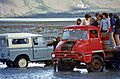
Crossing the Macauley River, Canterbury, New Zealand, 1977.
-
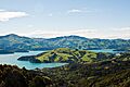
Upper Akaroa Harbour
-
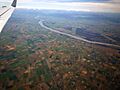
Canterbury Plains
-
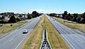
Christchurch Northern Motorway
-
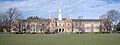
Christchurch Boys' High School
-
University of Canterbury
-
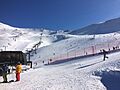
Skiing at Mount Hutt
See also
 In Spanish: Región de Canterbury para niños
