
Mackenzie District facts for kids
Quick facts for kids
Mackenzie District
|
|
|---|---|
|
Territorial authority district
|
|
 |
|

Mackenzie District within the South Island
|
|
| Country | New Zealand |
| Island | South Island |
| Region | Canterbury |
| Communities |
|
| Wards |
|
| Formed | 1989 |
| Seat | Fairlie |
| Area | |
| • Total | 7,339.23 km2 (2,833.69 sq mi) |
| • Land | 7,138.59 km2 (2,756.23 sq mi) |
| Population
(June 2023)
|
|
| • Total | 5,690 |
| • Density | 0.7753/km2 (2.0080/sq mi) |
| Postcode(s) |
Map of postcodes
|
The Mackenzie District is a special area in New Zealand's South Island. It is managed by the Mackenzie District Council. This district is part of the larger Canterbury Region. The area gets its name from the Mackenzie Basin, which is a large valley surrounded by mountains.
Contents
Exploring the Mackenzie District's Geography
The Mackenzie District is known for its stunning natural beauty. It has tall mountains, clear lakes, and wide-open spaces.
What are the main towns in Mackenzie District?
The Mackenzie District has four main towns:
- Fairlie: This is the main town where the district's government is located.
- Mount Cook Village: A small village close to New Zealand's highest mountain.
- Twizel: This is the largest town in the district.
- Lake Tekapo: A beautiful town by a famous lake.
Other smaller places to visit include:
What natural features can you find?
The Mackenzie District is home to many amazing natural landmarks.
Rivers and Mountains
You can find several important rivers here:
- Mackenzie River
- Tekapo River
- Pukaki River
- Grays River
The most famous mountain is Aoraki / Mount Cook, which is New Zealand's highest peak.
Lakes and Glaciers
The district has several beautiful lakes:
- Lake Tekapo is famous for its bright blue water and the 'Church of the Good Shepherd'.
- Lake Pukaki is another stunning blue lake.
- Lake Ruataniwha is a popular spot for rowing competitions.
- Lake Ōhau is known for its clear waters.
You can also see large glaciers like:
- Tasman Glacier
- Hooker Glacier
Skifields and National Parks
If you love skiing, there are several skifields:
- Fox Peak
- Mt Dobson
- Round Hill
- Tasman Glacier Heliski (where you can ski on a glacier!)
A big part of the district is covered by Aoraki / Mount Cook National Park.
Other Special Places
- Mackenzie Basin: The large valley that gives the district its name.
- Aoraki Mackenzie Dark Sky Reserve: A special place where the night sky is protected from light pollution, making it perfect for stargazing.
What is the climate like in Mackenzie District?
The Mackenzie District has a unique climate. Winters are clear, cold, and snowy, while summers are long and hot. In autumn, the trees show off amazing colours. Spring brings beautiful wildflowers, including lupins. Summer temperatures (November to February) can go above 30 degrees Celsius. In winter (June to September), temperatures often drop below freezing at night, but sunny days average around 8 degrees Celsius with regular snowfall.
A Brief History of Mackenzie District
The Mackenzie Basin was named in the 1850s after James Mckenzie. He was a shepherd from Scotland who was known for stealing sheep. The name of the basin then became the name for the modern district.
Who lives in the Mackenzie District?
The Mackenzie District covers about 7,138 square kilometers of land. In 2018, about 4,866 people lived here. This means there were about 0.68 people for every square kilometer.
In the 2023 New Zealand census, the population grew to 5,115 people. This was an increase of 5.1% since 2018. The average age of people living here was 41.1 years old.
What are the different ethnic groups?
People in the Mackenzie District come from many different backgrounds:
- 84.5% were European/Pākehā (people of European descent).
- 8.7% were Māori (New Zealand's indigenous people).
- 1.5% were Pasifika (people from Pacific Islands).
- 9.0% were Asian.
- 2.1% were Middle Eastern, Latin American, and African.
- 1.6% identified with other ethnic groups.
It's important to know that people can identify with more than one ethnic group.
What about religion and jobs?
When asked about religion in 2018:
- 51.7% said they had no religion.
- 37.1% were Christian.
- Smaller numbers followed Māori religious beliefs, Hinduism, Islam, Buddhism, or other religions.
For people aged 15 and older:
- 19.1% had a university degree or higher.
- 17.3% had no formal qualifications.
The average income was $33,400. Most people (60.3%) worked full-time.
How does the Mackenzie District make money?
_(8114524551).jpg)
In 2012, the Mackenzie District had 850 businesses. These businesses employed about 1,900 full-time workers and made $190 million. The main ways the district earns money are:
- Hydroelectric generation: Making electricity from water power.
- Farming: Raising animals and growing crops. This includes aquaculture (farming fish or other water creatures).
- Tourism: People visiting the beautiful area.
Most farms in 2012 were for sheep (34%) or a mix of sheep and beef cattle (18%). Only a small amount of crops like barley and oats were grown.
The district has many farms, but there have been concerns that large companies might take over family farms. This could potentially harm the local environment.
Who are the Mayors of Mackenzie District?
The Mayor is the elected leader of the Mackenzie District Council. Here is a list of people who have been Mayor:
- Bruce Scott: 1989–1992
- Neil Anderson: 1992–2001
- Stan Scorringe: 2001–2004
- John O'Neill: 2004–2010
- Claire Barlow: 2010–2016
- Graham Smith: 2016–2022
- Anne Munro: 2022–present
Images for kids
-
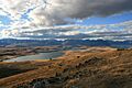
Several lakes in the Mackenzie Basin.
-
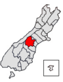
Map of Mackenzie District within the South Island.
