
Albury, New Zealand facts for kids
Quick facts for kids
Albury
|
|
|---|---|
|
Village
|
|

Albury
Location in New Zealand
|
|
| Country | New Zealand |
| Local iwi | Ngāi Tahu |
| Website | Mackenzie District Council |
Albury is a small village located in the southern part of the Canterbury region on the South Island of New Zealand. It's found inland from the city of Timaru, right on State Highway 8. This highway connects Pleasant Point and Fairlie. Albury is part of the beautiful Mackenzie Country. In 2013, about 66 people lived here.
Contents
A Glimpse into Albury's Past
Albury is in a farming area. For over six years in the 1800s, it was the end point for a branch railway line. This line later became known as the Fairlie Branch. The railway opened on January 1, 1877. It was extended beyond Albury to Winscombe in 1883. The Fairlie Branch railway closed on March 2, 1968. Even today, you can still see parts of the old railway line around Albury. It's believed that the Kennaway brothers named Albury. The village's post office closed on February 5, 1988, along with many others.
Learning in Albury
Albury School is a public primary school for both boys and girls. It teaches students from year 1 to year 6. As of February 2024. , the school has a roll of 28 students. The school first opened in 1882. It currently has two classrooms. One classroom is for students in years 1 and 2. The other is for students in years 3 to 6. Most children from Albury go on to high school at Mackenzie College in Fairlie.
How Albury Gets Its Water
The village of Albury and homes near SH8 get their water from the Downlands scheme. Most of the wider Albury area uses the Albury Rural Water Scheme. This scheme provides water for both farm animals and homes. Before these schemes, houses would pump water from rivers. They also got water from open water channels built for animals and people.
The Albury Scheme gets its water from a branch of the Opawa River. This system was built in the late 1960s and early 1970s. It works using only gravity, meaning no pumps are needed. Water flows downhill through the system. The scheme used one low dam until 2000-2002. Then, another branch of the river was dammed to get more water. This was needed because the water flow in the first branch was getting too low. The water is cleaned using a long, two-channel filter. This filter contains different sizes of gravel, with the largest at the bottom. This type of filter is called a sand filter. It doesn't need much looking after, just occasional cleaning by flowing water backwards through it.
Picture gallery
-
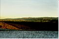
Taken from hills NE of Albury.
-
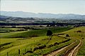
Looking from Mt Nessing area towards Fairlie
-
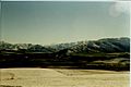
Looking from Mt Nessing area with Aoraki / Mount Cook in the distance


Local Groups and Activities
Albury has a few local clubs and organisations:
- Mount Nessing Collie Club
- Mount Nessing Golf Club
- Rural Women (formerly Women's Division of Federated Farmers)
Fun Local Events
Every year around March or April, the Albury Pub (tavern or bar) is the finish line for a mountain bicycle race. This race is called the "Pass to Pub". The race covers about 35 kilometers, starting from Burkes Pass and ending at the Albury Tavern. Local groups set up barbecues and sell things at the finish line to raise money for their activities.
