Pleasant Point, New Zealand facts for kids
Quick facts for kids
Pleasant Point
|
|
|---|---|
| Motto(s):
"The name says it all"
|
|
| Country | New Zealand |
| Region | Canterbury |
| Territorial authority | Timaru District |
| Community board | Pleasant Point Community Board |
| Ward | Pleasant Point-Temuka |
| Settled | 1864 |
| Electorates |
|
| Area | |
| • Total | 5.21 km2 (2.01 sq mi) |
| Elevation | 65 m (213 ft) |
| Population
(June 2023)
|
|
| • Total | 1,510 |
| • Density | 289.8/km2 (751/sq mi) |
| Time zone | UTC+12 (NZST) |
| • Summer (DST) | UTC+13 (NZDT) |
| Postcode |
7903
|
| Area code(s) | 03 |
| Local iwi | Ngāi Tahu |
Pleasant Point is a small town in southern Canterbury, New Zealand. It is about 19 kilometers inland from Timaru, located on State Highway 8. The town helps support the farms in the area.
One of its most popular attractions is the Pleasant Point Museum and Railway. This heritage railway runs old steam locomotives and a special replica of a Model T Ford railcar. It is one of only two such railcar replicas in the world. About 10,000 people visit the railway each year.
For nearly 100 years, a railway line called the Fairlie branch line ran through the town. It closed in 1968. Today, the heritage railway uses 2.5 kilometers of the old track.
Pleasant Point is also known for glassblowing, taxidermy, and blacksmithing. You can also find tasty custard squares there. Nearby, you can see ancient Māori rock art. Some Vineyards have also started growing grapes in the area.
The town has two primary schools, a preschool, and a play center. Pleasant Point High School closed in 2004. Two rivers, the Ōpihi and the TeNgawai, meet just north of the town. In 1901, the town's population was 749 people.
Contents
How Pleasant Point Got Its Name
Pleasant Point was not always the town's name. In the 1800s, wagon drivers traveled from Timaru to the Mackenzie Country. These trips took three to six weeks because the land had few tracks.
The wagoners would stop at campsites along the way. A popular stop was called "The Point." No one is sure exactly what "the point" referred to. Some people think it was where the Te Ngawai and Ōpihi rivers meet. Others believe it was a cut in the hill, perhaps near Manse Road.
"The Point" became a very popular camp. Campers started calling it "Pleasant Point." This was because it offered good food and water for their horses. There was also a hotel and pleasant surroundings.
Exploring Pleasant Point's Street Names
By 1870, the streets of Pleasant Point had been named and mapped. However, these names were not widely known. So, many streets were called by nearby landmarks.
For example, Halstead Road was often called School Road because the school was there. Harris Street was known as Church Street, as it was home to the first Anglican church. The Main Road was sometimes called Dominion Street. This name likely came from New Zealand becoming a Dominion.
As the town grew, street names became very important. Signs were put up for each street. The town was divided into different areas. Streets south of the railway line have names linked to Afghanistan. This might be because of the Anglo-Afghan wars that were happening at the time.
Streets in the northern part of town are named after early settlers or important landowners. William Halstead owned land on Halstead Road. John Porter Harris owned land on Harris Street. However, older maps called it Le Cren Street, after Henry John Le Cren, who used to own the land. Streets in the western part of town are named after native trees.
Who Lives in Pleasant Point?
Pleasant Point is a small urban area. It covers about 5.21 square kilometers. As of 2018, its population was 1,371 people.
| Historical population | ||
|---|---|---|
| Year | Pop. | ±% p.a. |
| 2006 | 1,194 | — |
| 2013 | 1,302 | +1.24% |
| 2018 | 1,371 | +1.04% |
The population increased by 69 people (5.3%) from 2013 to 2018. There were 558 homes in 2018. There were slightly more males (696) than females (675). The average age was 44.5 years.
About 19.7% of the people were under 15 years old. 14.4% were aged 15 to 29. 46.0% were aged 30 to 64, and 19.9% were 65 or older.
Most people (93.2%) were European/Pākehā. 10.7% were Māori. Smaller groups included Pasifika (0.7%) and Asian (1.3%). Some people identified with more than one ethnic group.
About 9.6% of the people were born outside New Zealand. This is lower than the national average of 27.1%.
When asked about religion, 50.5% said they had no religion. 37.9% were Christian. A small number had Māori religious beliefs (0.4%) or other religions (1.1%).
About 12.5% of people aged 15 or older had a university degree. 25.6% had no formal qualifications. The average income was $31,300. About 48.0% of people aged 15 or older worked full-time. 17.7% worked part-time, and 3.0% were unemployed.
Pleasant Point's Saleyards History
Pleasant Point was an important place for buying and selling farm animals. The first stock market in South Canterbury was held here on December 8, 1871.
A newspaper report from 1881 described the opening of the new saleyards. It said that the cattle yards were full with 400 animals. People thought the company would need to make them even bigger. The sheep pens were not used much at first, but everyone expected them to become very busy later.
The directors bought four acres of land. This allowed for future growth, as the area was good for farming. A nearby narrow bridge was replaced with a strong new one, making it easier to reach the saleyards.
By 1896, the Pleasant Point saleyards were the largest in South Canterbury. By 1905, they were the second largest in all of Canterbury, after Addington in Christchurch. In the 1970s, the Pleasant Point directors suggested joining with the Temuka Saleyard Company. The Pleasant Point Saleyards closed in 1979.
Cyclemakers in Pleasant Point
The Cyclemakers Group began making bicycles in Pleasant Point in October 1981. Ian Hooker was the managing director.
The company started with ten staff members. They designed and made bicycles at a site on Te Ngawai Road. By 1989, the business had grown to employ about 35 people.
Sadly, the factory was completely destroyed by a fire in April 1990. After the fire, the company moved to Washdyke.
Learning in Pleasant Point: Schools and Education
Pleasant Point currently has two primary schools and a preschool.
Pleasant Point Primary School teaches students from Year 1 to Year 8. It has about 257 students.
St Joseph's School is a Catholic primary school for students from Year 1 to Year 8. It has about 53 students.
Pleasant Point High School used to exist but closed in 2004. After it closed, high school students had to go to other schools, mainly in Timaru.
A school in Pleasant Point was first suggested in 1868. It opened that year on Tengawai Road. By 1871, the school moved to a new place on Harris Street. It soon needed more space, so an extra room was added. At that time, the school could hold 200 students. In 1907, a new school was built on seven acres. This is its current location on Halstead Road.
In 1911, 200 trees were planted next to the playground. This was a memorial to King George V's coronation. St Joseph's School opened in 1927.
When the high school closed in 2004, many of its resources went to the primary school next door. The rest were sold. The primary school changed a lot. It expanded to include intermediate students (Years 0–8) who would have gone to the high school. Some high school buildings were used to expand the primary school. The gym and sports courts became open for the community to use. The remaining buildings were sold and became the new preschool.
In 2018, the old concrete tennis and basketball courts were updated. They now have a new artificial turf. This turf can be used for many different sports, like hockey, netball, and tennis.
The Great Flood of 1986
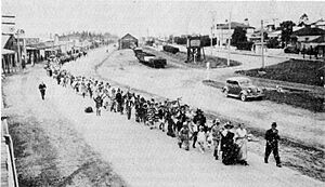
On March 13, 1986, Pleasant Point experienced the worst flood in South Canterbury's history. The flood was so bad that people in the western part of town had to leave their homes.
Up to five helicopters helped move people to dry ground. The flood caused millions of dollars in damage to the area.
 | Tommie Smith |
 | Simone Manuel |
 | Shani Davis |
 | Simone Biles |
 | Alice Coachman |


