Temuka facts for kids
Quick facts for kids
Temuka
|
|
|---|---|
|
Town
|
|
| Country | New Zealand |
| Region | Canterbury |
| Territorial authority | Timaru District |
| Community board | Temuka Community Board |
| Ward | Pleasant Point-Temuka |
| Electorates |
|
| Area | |
| • Total | 8.34 km2 (3.22 sq mi) |
| Elevation | 15 m (49 ft) |
| Population
(June 2023)
|
|
| • Total | 4,680 |
| • Density | 561.2/km2 (1,453.4/sq mi) |
| Postcode(s) |
7920
|
| Area code(s) | 03 |

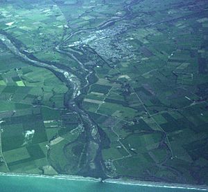
Temuka is a town in New Zealand on the Canterbury Plains. It is about 15 kilometres north of Timaru and 142 kilometres south of Christchurch. Temuka is a service town for a rich farming area, known for its sheep and dairy farms. It sits on the north bank of the Temuka River, close to where it joins the Ōpihi River.
Temuka is the second largest town in South Canterbury, after Timaru. The town has three schools: two primary schools and one secondary school. You can reach Temuka by State Highway 1 and the Main South Line railway, which helps with moving goods. The local secondary school, Opihi College, is named after the Ōpihi River. Both the Ōpihi and Temuka rivers are popular with locals and visitors. Most traffic traveling north or south in the area passes through or around Temuka. The town's local park, called the Domain, has been updated. It now includes a skate park along with other fun facilities like a swimming pool, mini golf, netball courts, outdoor bowls greens, and tennis courts. There are also fields for rugby and football, a stadium, and a holiday park.
Contents
Temuka's History and Growth
The name Temuka, or Te Muka, comes from the Māori words Te Umu-kaha. This is thought to mean either 'fierce ovens' or 'strong current'. The 'fierce ovens' might refer to the large earth ovens (called umu) that Māori used to cook cabbage tree roots. Temuka was first known as Wallingford.
Temuka officially became a town in 1858. The first survey of the town was done in 1863, and the first buildings were put up in 1860. Early businesses included a tannery (for making leather), a cheese factory, a flour mill, and potteries. A police station was built in 1863, and a telegraph office opened in 1868. In 1878, the Oddfellows and St George Masonic lodges were opened. The Temuka town board was set up in 1884. In 1899, the Wallingford and Arowhenua town areas became part of the Temuka borough.
In 1901, Temuka had 1465 people. By 1903, the town had two doctors, two chemists, and one dentist. It also had a well-kept park with a bicycle track, tennis, cricket, and football grounds. A new two-story post and telegraph office was opened in 1902.
Temuka was a stop on the Main South Line railway for passengers until those services stopped. In the past, Temuka also had wool cleaning plants, a flour mill, and made electric power transmission insulators.
On March 13, 1986, Temuka was hit by a big flood. The town was cut off when the bridge over State Highway 1 was washed away.
Temuka used to have its own local government. However, since 1989, it has been managed by the Timaru District Council. Recently, the council has been working to improve Temuka. This includes cleaning waterways, creating new walking paths, updating old ones, adding new gardens, and modernizing the town's facilities.
Arowhenua Marae
Arowhenua marae is a special meeting place for the Ngāi Tahu tribe and its Te Rūnanga o Arowhenua branch. It is located south of Temuka. This marae includes a main meeting house called Te Hapa o Niu Tireni wharenui.
In October 2020, the New Zealand Government provided $50,232 to help upgrade the marae. This project also created 16 jobs for people in the area.
Temuka's Population and People
Temuka is considered a small urban area by Statistics New Zealand. It covers about 8.34 square kilometres. As of 2018, its population was 4,470 people.
The population of Temuka has grown over the years. In 1951, there were 2212 people. By 2018, the population had increased to 4,470. This was an increase of 216 people since the 2013 census.
In 2018, there were 1,911 households in Temuka. There were slightly more females than males. About 17.7% of the population was under 15 years old. Most people were between 30 and 64 years old.
Most people in Temuka are of European/Pākehā background (90.0%). About 12.1% identify as Māori. Other ethnic groups include Pasifika, Asian, and others.
When asked about religion, 50.3% of people said they had no religion. About 39.0% were Christian. Smaller numbers followed Māori religious beliefs, Hinduism, Islam, or Buddhism.
Places of Worship
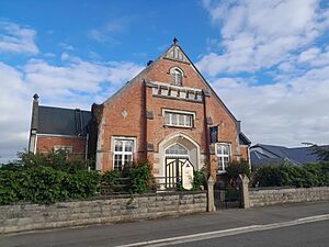
Trinity Presbyterian Church
The Trinity Presbyterian church was damaged during the 2010 Canterbury earthquakes. Because of the damage, it had to be taken down. The church building was 120 years old. The Sunday school hall, which was built after 1915, was used as a hospital during the 1918 influenza outbreak.
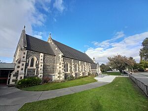
Saint Peter's Anglican Church
Saint Peter's Anglican Church was built in 1899. It can seat up to 300 people. This church also suffered damage during the 2010 Canterbury earthquakes.
Schools in Temuka
Temuka has three schools for students of different ages.
Temuka Primary School
Temuka Primary School is for students in years 1 to 6. It has about 210 students. A public school for both primary and secondary students first opened in 1866. It moved to its current location in the late 1870s. The secondary school later moved to its own separate site in 1968.
St. Joseph's School
St. Joseph's School is a Catholic school for students in years 1 to 8. It has about 110 students. This school first opened its doors in 1883.
Opihi College
Opihi College is a secondary school for students in years 7 to 13. It has about 354 students. It was first called Temuka District High School. Then it became Temuka High School when it moved to its current site. In 2005, its name was changed to Opihi College.
All these schools teach both boys and girls.
Sports and Fun in Temuka
Temuka Rugby Club
The Temuka Rugby Club started in 1875. Four players from this club have gone on to play for the All Blacks, New Zealand's national rugby team. These players were Lachie Grant, Tom Coughlan, Archie Strang, and Gus Spillane.
Temuka Golf Club
The Temuka Golf Club was founded in 1907. It started as a 9-hole golf course but has since grown to 18 holes. The golf course was badly flooded in May 2021 when the Temuka River overflowed. The water was up to two metres high in some places. Flooding also closed the course for six months in 1986.
Temuka Bowling Club
The Temuka Bowling Club was started in 1906. It is located in the Temuka Domain. The club hosts several tournaments throughout the year, including the "Temuka 3000" around New Year's.
Temuka Swimming Pool
The Temuka summer pool is open from mid-November to late March each year. It is also located at the Temuka Domain. The pool has six lanes and is 25 metres long. There is also a separate pool for toddlers. Both outdoor pools are heated.
Temuka Museum
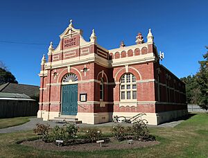
The Temuka courthouse museum has more than 6000 items. These items tell the story of Temuka's local history. The museum is in the old courthouse building, which was built between 1900 and 1901. It was used as a courthouse until 1979. In 2020, the building needed to be made stronger to withstand earthquakes. This work was paid for by a grant from the New Zealand Lottery Environment and Heritage Fund.
Businesses in Temuka
Temuka is home to several important businesses. Temuka Transport is a large trucking company with about 40 trucks. These trucks help move goods around the South Canterbury area. Another local business is Temuka Homeware, which makes ceramic dishes and pottery. Older, traditional items from this company are now popular with collectors.
Temuka also has New Zealand Insulators (NZI), which is the main supplier of insulators for New Zealand's power industry. NZI's main office, South Island warehouse, and local factory are all in Temuka. The town is also home to Gannaway New Zealand, the only company in New Zealand that makes bagpipe bags. They use cowhide, goatskin, and sheepskin to make bags that are sent all over the world. You can also find supermarkets, takeaway restaurants, hardware stores, office supply stores, and art galleries in Temuka.
Famous People from Temuka
- Rachel Armitage (1873–1955), a welfare worker who helped people.
- Ned Barry (1905–1993), a rugby union player.
- Horace Fildes (1875–1937), a postmaster and book collector.
- John Lister (born 1947), a professional golfer.
- Richard Pearse (1877–1953), an aviation pioneer who experimented with flight.
- Hipa Te Maihāroa (?–1886), a Māori tribal leader and prophet.
- Jeremiah Twomey (1847–1921), a member of the New Zealand Parliament.
- Lachie Grant (1923–2002), a rugby union player.
Temuka's Climate
| Climate data for Temuka (1981–2010 normals, extremes 1963–1994) | |||||||||||||
|---|---|---|---|---|---|---|---|---|---|---|---|---|---|
| Month | Jan | Feb | Mar | Apr | May | Jun | Jul | Aug | Sep | Oct | Nov | Dec | Year |
| Record high °C (°F) | 35.4 (95.7) |
39.4 (102.9) |
33.2 (91.8) |
30.0 (86.0) |
26.0 (78.8) |
24.0 (75.2) |
21.5 (70.7) |
22.0 (71.6) |
25.6 (78.1) |
29.6 (85.3) |
32.7 (90.9) |
33.4 (92.1) |
39.4 (102.9) |
| Mean daily maximum °C (°F) | 21.8 (71.2) |
21.0 (69.8) |
19.5 (67.1) |
17.4 (63.3) |
14.4 (57.9) |
11.7 (53.1) |
11.0 (51.8) |
12.5 (54.5) |
14.7 (58.5) |
16.5 (61.7) |
18.0 (64.4) |
19.8 (67.6) |
16.5 (61.7) |
| Daily mean °C (°F) | 16.1 (61.0) |
15.8 (60.4) |
14.0 (57.2) |
11.5 (52.7) |
8.7 (47.7) |
6.0 (42.8) |
5.4 (41.7) |
6.9 (44.4) |
9.0 (48.2) |
10.8 (51.4) |
12.6 (54.7) |
14.6 (58.3) |
11.0 (51.7) |
| Mean daily minimum °C (°F) | 10.4 (50.7) |
10.5 (50.9) |
8.5 (47.3) |
5.6 (42.1) |
3.0 (37.4) |
0.3 (32.5) |
−0.1 (31.8) |
1.3 (34.3) |
3.4 (38.1) |
5.0 (41.0) |
7.1 (44.8) |
9.5 (49.1) |
5.4 (41.7) |
| Record low °C (°F) | 1.9 (35.4) |
2.0 (35.6) |
−2.0 (28.4) |
−3.0 (26.6) |
−7.7 (18.1) |
−6.8 (19.8) |
−6.3 (20.7) |
−5.6 (21.9) |
−4.2 (24.4) |
−4.3 (24.3) |
−1.0 (30.2) |
0.8 (33.4) |
−7.7 (18.1) |
| Average rainfall mm (inches) | 40.3 (1.59) |
60.4 (2.38) |
58.9 (2.32) |
38.3 (1.51) |
49.0 (1.93) |
30.9 (1.22) |
51.4 (2.02) |
48.2 (1.90) |
42.3 (1.67) |
50.2 (1.98) |
53.6 (2.11) |
62.0 (2.44) |
585.5 (23.07) |
| Source: NIWA | |||||||||||||
 | Lonnie Johnson |
 | Granville Woods |
 | Lewis Howard Latimer |
 | James West |


