2010 Canterbury earthquake facts for kids
| UTC time | 2010-09-03 16:35:46 |
|---|---|
| ISC event | 15155483 |
| USGS-ANSS | ComCat |
| Local date | 4 September 2010 |
| Local time | 04:35 NZST |
| Magnitude | 7.1 Mw |
| Depth | 10 km (6.2 mi) |
| Epicenter | 43°33′S 172°11′E / 43.55°S 172.18°E near Darfield, Canterbury |
| Areas affected | New Zealand |
| Max. intensity | X (Extreme) |
| Peak acceleration | 1.26 g |
| Aftershocks | ~17,600 (as of early August 2016) |
| Casualties | 2 seriously injured, approximately 100 total injuries |
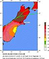
The 2010 Canterbury earthquake was a very strong earthquake that hit the South Island of New Zealand. It happened early in the morning on September 4, 2010, at 4:35 am local time.
The earthquake had a magnitude of 7.1 on the moment magnitude scale. This scale helps scientists measure how much energy an earthquake releases. The quake's center was about 40 km west of Christchurch, near a town called Darfield. It happened 10 km deep inside the Earth.
Many smaller earthquakes, called aftershocks, happened after the main quake. Some of these were quite strong, like one that measured 5.3 magnitude. People felt the main earthquake all over the South Island and even in parts of the North Island.
The earthquake caused a lot of damage, especially in Christchurch. Power and water supplies were cut off in many areas. Two people were seriously hurt, and about 100 people had other injuries. Old buildings in Lyttelton, near Christchurch, were also damaged. Many businesses in the city center had to close. The total cost of the damage was estimated to be around NZ$2 billion.
Because of the serious damage, a state of emergency was announced for Christchurch and the Selwyn District. This means that special rules were put in place to help with rescue and recovery efforts.
What Caused the Earthquake?
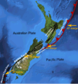
New Zealand is located on the edge of two huge pieces of the Earth's crust, called tectonic plates. These are the Australian Plate and the Pacific Plate. These plates are always moving, but very slowly.
In the South Island, these plates mostly slide past each other. This movement can cause earthquakes along cracks in the Earth's crust called fault lines. A very big fault line in New Zealand is the Alpine fault.
The 2010 Canterbury earthquake happened about 80–90 km away from the main plate boundary. It likely happened on one of the smaller fault lines that are connected to the bigger faults.
Images for kids
-
The Medway footbridge over the Avon River after the earthquake.
-
Damage to buildings on Worcester Street, with Christchurch Cathedral in the background.
-
Central Kaiapoi was badly damaged. Many buildings had to be knocked down after this quake and another one in 2011.
-
Workers used props to hold up the front of the Oxford Terrace Baptist Church after the earthquake.
See also
 In Spanish: Terremoto de Christchurch de 2010 para niños
 | Misty Copeland |
 | Raven Wilkinson |
 | Debra Austin |
 | Aesha Ash |


