
Darfield, New Zealand facts for kids
Quick facts for kids
Darfield
|
|
|---|---|
|
Minor urban area
|
|

Darfield sign on New Zealand State Highway 73, the main street of Darfield
|
|
| Country | New Zealand |
| Region | Canterbury |
| Territorial authority | Selwyn District |
| Ward | Malvern |
| Community | Malvern |
| Electorates |
|
| Area | |
| • Total | 17.58 km2 (6.79 sq mi) |
| Elevation | 205 m (673 ft) |
| Population
(June 2023)
|
|
| • Total | 3,150 |
| • Density | 179.2/km2 (464.1/sq mi) |
| Time zone | UTC+12 (NZST) |
| • Summer (DST) | UTC+13 (NZDT) |
| Postcode(s) |
7510
|
| Area code(s) | 03 |
| Local iwi | Ngāi Tahu |
Darfield is a town in the Selwyn District on the South Island of New Zealand. It is about 35 kilometres (22 miles) west of Christchurch. As of June 2023, about 3,150 people live there.
Darfield is an important town between Christchurch and the West Coast region. People often call it "The township under the nor'west arch". This name comes from a special weather event. An arch of clouds often appears in the sky to the west of the town. This happens when water particles are pushed up over the Southern Alps, forming clouds.
Darfield is in an area known for farming. It's a great starting point to explore the beautiful Waimakariri and Rakaia rivers. You can also see the Southern Alps from here. It's a popular spot for hot air ballooning too!
The town is located where old railway lines used to meet. These lines came from Christchurch and went to places like Whitecliffs (where coal was mined) and Springfield. From Springfield, the line continued to the West Coast.
Contents
Discovering Darfield's Past
Darfield was first known as White Cliffs Junction. Later, in 1879, its name changed to Horndon Junction. This name was changed again to avoid confusion with Hornby Junction, another railway spot near Christchurch.
The town got its current name, Darfield, from a person named John Jebson. He named it after a village in Yorkshire, England. The name "Darfield" means "a field where deer often visit."
In 1887, a stone mill was built in Darfield. This mill was used to grind flour. It was powered by a water channel managed by the Selwyn County Council.
Darfield Today: From Earthquakes to Factories
A big earthquake, measuring 7.1 on the Richter scale, happened near Darfield on September 4, 2010. It struck at 4:35 am and caused a lot of damage in the town and nearby areas, including Christchurch.
In 2013, a large milk processing factory opened in Darfield. The company Fonterra invested $500 million in this factory. It has the world's biggest dryer, which is used to make instant whole milk powder.
Darfield's Weather
Darfield is on the Canterbury Plains, about 205 metres (673 feet) above sea level. It has an oceanic climate, which means it has mild temperatures all year.
Sometimes, Darfield experiences a special wind called the "nor'west Foehn wind." This wind is very dry and can make the temperature rise quickly. On the other hand, especially in winter, cold winds from the Southern Ocean can blow in, making the town very chilly.
The average temperature in Darfield is about 11.9°C (53.4°F). The hottest temperature ever recorded was 40.7°C (105.3°F) on February 7, 1973. The coldest was -11.8°C (10.8°F) on June 7, 2012. Each year, Darfield usually has about 45 days where the temperature goes above 25°C (77°F). It also has about 34 nights where the temperature drops below 0°C (32°F).
| Climate data for Darfield (1991–2020 normals, extremes 1939–2015) | |||||||||||||
|---|---|---|---|---|---|---|---|---|---|---|---|---|---|
| Month | Jan | Feb | Mar | Apr | May | Jun | Jul | Aug | Sep | Oct | Nov | Dec | Year |
| Record high °C (°F) | 38.4 (101.1) |
40.7 (105.3) |
37.6 (99.7) |
28.9 (84.0) |
27.2 (81.0) |
22.3 (72.1) |
21.0 (69.8) |
23.3 (73.9) |
27.8 (82.0) |
30.0 (86.0) |
32.1 (89.8) |
36.5 (97.7) |
40.7 (105.3) |
| Mean daily maximum °C (°F) | 23.6 (74.5) |
23.4 (74.1) |
21.4 (70.5) |
17.8 (64.0) |
14.6 (58.3) |
11.1 (52.0) |
10.8 (51.4) |
12.9 (55.2) |
15.4 (59.7) |
17.5 (63.5) |
19.6 (67.3) |
21.9 (71.4) |
17.5 (63.5) |
| Daily mean °C (°F) | 17.3 (63.1) |
17.1 (62.8) |
15.3 (59.5) |
12.3 (54.1) |
9.6 (49.3) |
6.7 (44.1) |
6.2 (43.2) |
7.7 (45.9) |
9.8 (49.6) |
11.6 (52.9) |
13.4 (56.1) |
15.7 (60.3) |
11.9 (53.4) |
| Mean daily minimum °C (°F) | 10.9 (51.6) |
10.7 (51.3) |
9.1 (48.4) |
6.8 (44.2) |
4.6 (40.3) |
2.2 (36.0) |
1.6 (34.9) |
2.6 (36.7) |
4.2 (39.6) |
5.7 (42.3) |
7.1 (44.8) |
9.5 (49.1) |
6.3 (43.3) |
| Record low °C (°F) | 0.6 (33.1) |
−0.4 (31.3) |
−1.0 (30.2) |
−2.6 (27.3) |
−5.3 (22.5) |
−11.8 (10.8) |
−9.0 (15.8) |
−6.1 (21.0) |
−4.8 (23.4) |
−3.5 (25.7) |
−2.6 (27.3) |
0.1 (32.2) |
−11.8 (10.8) |
| Average rainfall mm (inches) | 55.2 (2.17) |
54.2 (2.13) |
58.1 (2.29) |
62.7 (2.47) |
65.9 (2.59) |
82.9 (3.26) |
69.6 (2.74) |
74.1 (2.92) |
56.1 (2.21) |
63.9 (2.52) |
57.4 (2.26) |
69.3 (2.73) |
769.4 (30.29) |
| Source: NIWA | |||||||||||||
Who Lives in Darfield?
Darfield is a small urban area that covers about 17.58 square kilometres. As of June 2023, its estimated population is 3,150 people.
| Historical population | ||
|---|---|---|
| Year | Pop. | ±% p.a. |
| 2006 | 1,974 | — |
| 2013 | 2,397 | +2.81% |
| 2018 | 2,724 | +2.59% |
In 2018, Darfield had a population of 2,724 people. This was a good increase of 327 people (13.6%) since 2013. The population has grown quite a bit since 2006, with 750 more people (38.0%).
The median age in Darfield was 43.9 years. This is a bit older than the national average of 37.4 years. About 18.6% of the people were under 15 years old, and 20.7% were 65 or older.
Most people in Darfield are of European (Pākehā) background (94.6%). There are also people of Māori (6.6%), Pasifika (1.4%), and Asian (2.0%) backgrounds. About 16.3% of the people in Darfield were born outside New Zealand.
When it comes to religion, 52.5% of people said they had no religion. About 38.3% were Christian. A small number of people followed other religions like Hinduism, Islam, or Buddhism.
The median income in Darfield was $36,400, which was higher than the national median of $31,800. Many people in Darfield work full-time (51.7%), and some work part-time (14.6%).
Back in 1971, Darfield had a population of 830 people.
Learning in Darfield
Darfield has several kindergartens for young children. The first Darfield school opened in 1883 with just 18 students. By 1902, it had two teachers and 93 students.
Darfield Primary School is the local primary school for students in years 1 to 6. It has 256 students.
Darfield High School is the intermediate and high school for students in years 7 to 13. It has 827 students. This school started in 1951 as a high school and began teaching intermediate students in 1978.
Both schools welcome both boys and girls. The student numbers are as of February 2024. .
Darfield's Industries
Darfield is home to several businesses. These include brick-making, seed cleaning, and a large Fonterra factory. This factory processes milk into powder. The factory has its own railway tracks and a place to load containers onto trains.
Services and Community Life

Darfield has a shopping area along its main street, including a Four Square supermarket. The town also has many churches, like St Joseph's Catholic Church and Trinity Church (which is shared by Anglicans, Methodists, and Presbyterians). There are also two resthomes for older people.
Darfield has important emergency services, including police, fire, and ambulance stations. It also has a medical centre and a hospital.
Most homes in Darfield use their own septic tanks for wastewater, as the town is not connected to a larger sewage system.
Fun and Recreation
Darfield has a large community area called the domain. Here you can find duck ponds and a community centre. There are also fields for football and rugby, tennis courts, and a Scouts building.
Westview Park is another great spot, located near the railway line and State Highway 73. It has interesting features like the Whitecliffs Branch historical site and a skatepark.
McHughs Forest Park is just northwest of Darfield. It was planted in 1893 to provide wood for the Canterbury area. The forest has many different types of trees, like Douglas Fir and Pinus Radiata. There are also walking tracks for you to explore.
Getting Around Darfield

Bus Services
Darfield has a bus service, the 86 bus route. This is an express bus that runs in the morning and evening. It connects Darfield to Central Christchurch, passing through towns like Kirwee, West Melton, and Yaldhurst.
Train Travel
Darfield is on the Midland railway line. The famous TranzAlpine train stops here twice a day if you request it. This train travels to the West Coast and then returns to Christchurch.
Roads for Driving
Darfield is located on State Highway 73, also known as the Great Alpine Highway. This road connects Christchurch to the West Coast region. Darfield is also connected by State Highway 77, which goes to Ashburton through places like Methven, the Rakaia Gorge, and Glentunnel.
Famous People from Darfield
- Sir Allan Wright (born 1929): A well-known farmer and the first leader of Lincoln University.
- Geoff Wright (born 1929): A New Zealand cricketer.
- John Wright (born 1954): A New Zealand cricketer and a former coach for the Indian national cricket team.
- Henry Shipley (born 1996): A New Zealand cricketer.
- Brian Connell (born 1956): A politician.
- Mary Clinton (born 1960): A New Zealand field hockey player.
- James Te Huna (born 1981): The first New Zealander to join the UFC (Ultimate Fighting Championships) in 2010.
Gallery
-

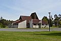
St Joseph's Catholic Church, October 2013
-
Trinity Church, October 2013
-
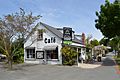
Cafe in central Darfield, October 2013
-
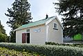
Historic jail dating 1915, October 2013
-
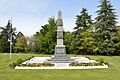
Darfield War Memorial, located next to Trinity Church, October 2013


See also
 In Spanish: Darfield (Nueva Zelanda) para niños
