
Ashburton, New Zealand facts for kids
Quick facts for kids
Ashburton
Hakatere (Māori)
|
|
|---|---|
|
Secondary urban area
|
|

Aerial view of Ashburton, looking west. The Ashburton River/Hakatere is visible at left.
|
|
| Nickname(s):
Ashvegas
|
|
| Country | New Zealand |
| Region | Canterbury |
| District | Ashburton District Council |
| Ward | Ashburton |
| Electorates |
|
| Area | |
| • Territorial | 39.99 km2 (15.44 sq mi) |
| Population
(June 2023)
|
|
| • Territorial | 20,800 |
| • Density | 520.1/km2 (1,347/sq mi) |
| Demonym(s) | Ashburtonian |
| Time zone | UTC+12 (NZST) |
| • Summer (DST) | UTC+13 (NZDT) |
| Postcode(s) |
Map of postcodes
|
| Postcode(s) |
7700
|
| Area code(s) | 03 |
| Local iwi | Ngāi Tahu |
Ashburton (in Māori, Hakatere) is a big town in the Canterbury Region of New Zealand. It's located on the east coast of the South Island. Ashburton is the main town of the Ashburton District.
The town is about 85 kilometres (53 miles) southwest of Christchurch. Sometimes, people think of it as a smaller town connected to Christchurch. Ashburton has a population of 20,800. This makes it the 29th largest urban area in New Zealand. It is also the fourth largest in the Canterbury Region, after Christchurch, Timaru, and Rolleston.
The Name of Ashburton
Ashburton was named by a surveyor named Captain Joseph Thomas. He named it after Francis Baring, who was a member of the Canterbury Association.
Sometimes, people jokingly call Ashburton "Ashvegas." This is a funny comparison to Las Vegas, a famous city known for its bright lights and entertainment.
Hakatere is the traditional Māori name for the Ashburton River. This name means "to make swift" or "to flow smoothly."
Ashburton's History
In 1858, a man named William Turton started a ferry service across the Ashburton River. He also built a guesthouse and stables. These were the only buildings in Ashburton in 1863.
By 1864, horse-drawn coaches from the Cobb and Co. company traveled through Ashburton. These coaches went between Christchurch and Timaru until the railway line was built.
The town was officially planned in 1864 by Robert Park. He designed it with two main squares, Baring Square East and Baring Square West. These squares are on either side of the railway line and main highway. The Ashburton Domain, a large park, was also part of the original plans. It was set aside for gardens and recreation.
In 1873, the Canterbury government gave money to build roads in the area. The railway reached Ashburton in 1874, making travel and trade easier.
Churches were built in the town: the Presbyterian church in 1876, the Wesleyan church in 1878, and the Catholic church in 1882.
Ashburton became a borough (a type of town) in 1878. At that time, there were about 500 buildings. A cricket pitch was set up in the Ashburton Domain in 1878, and the Ashburton Hospital opened in 1879.
Electricity came to Ashburton in 1908. It was first supplied by a small generator. By 1927, many homes and businesses had electricity.
Over the years, several nearby areas joined Ashburton. Netherby was added in 1917, Hampstead in 1921, and Allenton in 1939. Tinwald became part of the borough in 1955.
During World War 2, Ashburton was a training base for the Royal New Zealand Air Force. About 50 Tiger Moth planes were based there.
In 2021, the Ashburton District Council decided to stop using the town's slogan, "Whatever it takes." This slogan had been used for about 10 years but had received some criticism.
A big project started in April 2021 to build a new library and civic centre for Ashburton. This project costs $42 million, with $20 million from the New Zealand government. The new building will have three floors. It will include council offices, a recording studio, study areas, a library, and a performance space. It will also include the historic Pioneer Hall. The library will be called Te Pātaka o kā Tuhituhi, and the civic centre will be Te Waharoa a Hine Paaka.
A new shopping area called "River Crossing" is also planned to open in 2022. Local developers hope this will encourage people to shop more in Ashburton. This project is expected to create between 150 and 180 jobs.
Ashburton's Geography

Town Location
Ashburton is located 17 kilometres (11 miles) inland on the Canterbury Plains. It is about 86 kilometres (53 miles) south of Christchurch and 75 kilometres (47 miles) north of Timaru. Methven is 33 kilometres (21 miles) inland from Ashburton. The town of Rakaia and the Rakaia River are 28 kilometres (17 miles) north of Ashburton.
The town is a hub for farming in the Canterbury Plains. It has one large suburb called Tinwald, which is south of the Ashburton River / Hakatere. Ashburton also has three other suburbs: Allenton, Hampstead, and Netherby.
Ashburton's Climate
Ashburton has a climate similar to Christchurch, which is a dry temperate climate (Cfb). However, because Ashburton is further inland and higher up, it has a wider range of temperatures.
Summers in Ashburton can be warm. On average, there are 39 days each year when the temperature goes above 25°C (77°F). About 7 days each year, it gets hotter than 30°C (86°F).
Winters are frosty, with temperatures dropping below 0°C (32°F) on about 51 nights a year. Snow sometimes falls in Ashburton. The heaviest snowfall was 38 centimetres (15 inches) on June 12, 2006. Ashburton also holds the record for New Zealand's fourth-highest temperature ever recorded, reaching 41.3°C (106.3°F) on February 7, 1973.
| Climate data for Ashburton (Ashburton Aerodrome) (1991–2020 normals, extremes 1928–present) | |||||||||||||
|---|---|---|---|---|---|---|---|---|---|---|---|---|---|
| Month | Jan | Feb | Mar | Apr | May | Jun | Jul | Aug | Sep | Oct | Nov | Dec | Year |
| Record high °C (°F) | 39.4 (102.9) |
41.3 (106.3) |
36.0 (96.8) |
30.7 (87.3) |
26.8 (80.2) |
23.0 (73.4) |
21.9 (71.4) |
24.2 (75.6) |
28.8 (83.8) |
30.0 (86.0) |
33.8 (92.8) |
36.3 (97.3) |
41.3 (106.3) |
| Mean daily maximum °C (°F) | 22.1 (71.8) |
21.8 (71.2) |
20.0 (68.0) |
16.9 (62.4) |
14.2 (57.6) |
11.1 (52.0) |
11.0 (51.8) |
12.2 (54.0) |
14.7 (58.5) |
16.7 (62.1) |
18.5 (65.3) |
20.4 (68.7) |
16.6 (62.0) |
| Daily mean °C (°F) | 16.2 (61.2) |
16.1 (61.0) |
14.4 (57.9) |
11.4 (52.5) |
8.9 (48.0) |
6.0 (42.8) |
5.7 (42.3) |
7.0 (44.6) |
9.1 (48.4) |
10.9 (51.6) |
12.7 (54.9) |
14.8 (58.6) |
11.1 (52.0) |
| Mean daily minimum °C (°F) | 10.4 (50.7) |
10.4 (50.7) |
8.7 (47.7) |
5.9 (42.6) |
3.6 (38.5) |
1.0 (33.8) |
0.5 (32.9) |
1.8 (35.2) |
3.4 (38.1) |
5.2 (41.4) |
7.0 (44.6) |
9.2 (48.6) |
5.6 (42.1) |
| Record low °C (°F) | 0.3 (32.5) |
−0.4 (31.3) |
−1.3 (29.7) |
−2.9 (26.8) |
−6.7 (19.9) |
−7.1 (19.2) |
−11.6 (11.1) |
−7.8 (18.0) |
−4.8 (23.4) |
−3.2 (26.2) |
−2.9 (26.8) |
−1.5 (29.3) |
−11.6 (11.1) |
| Average rainfall mm (inches) | 51.2 (2.02) |
64.3 (2.53) |
46.4 (1.83) |
58.8 (2.31) |
82.3 (3.24) |
81.2 (3.20) |
68.4 (2.69) |
66.5 (2.62) |
37.1 (1.46) |
67.8 (2.67) |
52.8 (2.08) |
69.1 (2.72) |
745.9 (29.37) |
| Mean monthly sunshine hours | 225.8 | 201.3 | 192.2 | 180.7 | 156.3 | 133.6 | 153.7 | 166.0 | 207.8 | 233.1 | 245.3 | 217.4 | 2,313.2 |
| Source: NIWA | |||||||||||||
Rivers and Lakes
The Ashburton River / Hakatere flows from the Southern Alps to the Pacific Ocean. Its official name became a dual name in 1998. The river runs through Ashburton, separating the suburb of Tinwald from the rest of the town.
The closest beach to Ashburton is Wakanui Beach. However, it is not safe for swimming because of strong currents. To make up for the lack of safe swimming spots, Lake Hood was built near Tinwald. The Ashburton lakes, including Lake Heron, Lake Camp, and Lake Clearwater, are located inland. On the way to these lakes, you can find Mount Somers and the Mount Somers walkway.
Local Government
The Ashburton District Council is in charge of the Ashburton District. The council is led by the mayor of Ashburton, who is currently Neil Brown. There are also nine councillors who represent different areas.
People of Ashburton
Ashburton is considered a medium-sized urban area by Statistics New Zealand. It covers about 39.99 square kilometres (15.44 sq mi). The estimated population is 20,800 as of June 2023. . This means there are about 520 people per square kilometre.
The population of Ashburton has grown over the years:
- 1901: 2,322 people
- 1951: 8,287 people
- 1956: 10,176 people
- 1961: 11,604 people
| Historical population | ||
|---|---|---|
| Year | Pop. | ±% p.a. |
| 2006 | 16,188 | — |
| 2013 | 17,883 | +1.43% |
| 2018 | 19,284 | +1.52% |
In 2018, Ashburton had a population of 19,284 people. This was an increase of 1,401 people (7.8%) since 2013. There were 7,644 households. The population included 9,531 males and 9,747 females.
About 18.9% of the people were under 15 years old. 17.3% were aged 15 to 29. 41.4% were aged 30 to 64. And 22.5% were 65 or older.
Most people in Ashburton (82.9%) are of European descent. Other groups include Māori (9.1%), Pasifika (7.7%), and Asian (5.8%). About 17.0% of the people were born overseas.
When asked about religion, 43.0% said they had no religion. 46.8% were Christian. Other religions included Māori religious beliefs (0.7%), Hindu (0.8%), Muslim (0.3%), and Buddhist (0.4%).
Of those aged 15 or older, 10.4% had a university degree or higher. 27.1% had no formal qualifications. About 13.2% earned over $70,000 a year. Most people (48.8%) worked full-time, and 14.9% worked part-time.
Ashburton's Economy
Ashburton's economy is closely linked to the wider Ashburton District. In 2020, the district's total economic output (GDP) was $2,506 million.
The biggest part of Ashburton District's economy comes from farming and other primary industries. This makes up 27.0% of the local economy. This is much higher than the national average for primary industries, which is 6.2%.
Other important parts of the economy include 'Other services' (26.7%) and 'Goods-producing industries' (21.3%). Services that require special knowledge, like tech companies, make up a smaller part of the economy (10.2%).
The town has many businesses that support farming. These include places that sell seeds, companies that deal with livestock, farm machinery dealers, banks, lawyers, and accountants.
Farming and Agriculture
Ashburton is located in the middle of the fertile alluvial Canterbury Plains. This area is great for farming, especially dairy farming, with the help of irrigation. More than 100 local farmers grow potatoes, corn, and peas. These crops are then processed right in the area.
The Ashburton District Council owns 40% of the company that manages the Rangitata Diversion Race. This system moves water from the Rangitata and South Ashburton rivers into a canal. This canal provides water for irrigation to many farms in the district.
Vegetable Processing
A large factory owned by Talley's is located on the northern edge of Ashburton. This factory processes vegetables. It was built in 1996 because the Ashburton area has good soil and irrigation.
The factory processes peas, corn, and potatoes. The potatoes are turned into French fries, hash browns, and potato wedges. A lot of these processed vegetables are sent to other countries. The factory employs 360 people.
Meat Processing
Ashburton used to have a lamb processing factory from the early 1900s. However, it closed in 2017, which meant 370 people lost their jobs. This happened because there were fewer lambs in Canterbury. The part of the factory that processed animal skins closed in 2019, leading to 44 more job losses.
Talley's bought the site in 2020. They plan to use it to help with their vegetable production and to store their frozen produce.
Cooperative Companies
In 2012, Ashburton was known for having more cooperative companies than any other area in New Zealand. Because of this, the New Zealand Cooperatives Association called it the "Cooperative Capital of New Zealand."
Many of these companies are national ones, like Fonterra (dairy), Foodstuffs (supermarkets), and Silver Fern Farms (meat processing). But many are local cooperatives, such as the Ashburton Trading Society (farm supplies) and Electricity Ashburton (electricity).
Ashburton's Culture

Museum and Art Gallery
The Ashburton Museum and Art Gallery are located in the same building. This building is on State Highway 1, just outside the town centre.
The museum has a permanent exhibition that shows the history of the Ashburton district. It also hosts temporary exhibitions. When the art gallery opened in 2015, it had a funny problem. The new air-conditioning unit from Italy hadn't arrived, so they couldn't hang any of their 2,700 artworks on the walls!
Marae
The Hakatere marae is on the northern edge of Ashburton. A marae is a special meeting place for Māori people. Even though Ashburton is in the area of the Ngāi Tahu iwi (tribe), the Hakatere marae was built for people from all iwi.
The marae is on land that used to be the Fairton Primary School. This land was bought in 1970, and the Hakatere marae was officially recognized as a Māori reserve in 1976. Sadly, the wharenui (meeting house) was destroyed by a fire in 2003. The wharekai (dining hall) was finished in 2007.
Things to See and Do
Ashburton Domain
The Ashburton Domain is a large park in the centre of Ashburton, right next to State Highway 1. It is 37 hectares (91 acres) in size.
The domain has beautiful public gardens, cricket pitches, football fields, and tennis courts. There are also clubs for bowls and croquet. Kids can enjoy the playground and a paddling pool.
Railway Museum
The Plains Vintage Railway and Historical Museum is in the Tinwald Domain. You can ride a train on about three kilometres (1.9 miles) of old railway line. This line used to be part of the Mount Somers Branch. The museum also has many old buildings and trains on display.
Ashburton Aviation Museum
The Ashburton Aviation Museum is at the Ashburton Airport. It has two buildings with almost thirty aircraft. These include a Skyhawk that was used by the New Zealand Air Force, a Vampire FB5, and a Canberra B2 Bomber. The museum also has the only British Aerospace HS Harrier "Jump-jet" GR3 in the Southern Hemisphere.
-
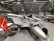
Ashburton Aviation Museum (2023)
-
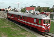
Vulcan Railcar on exhibition at the railway museum
-
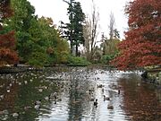
Ashburton Domain


Important Buildings
- Notable buildings
-
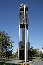
Ashburton Clock Tower (March 2008)
-
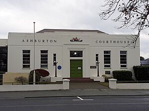
Ashburton Courthouse (July 2021)
-
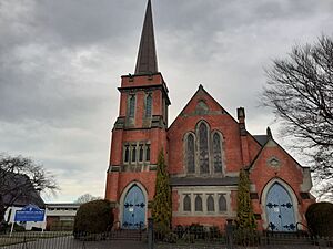
St Andrews Presbyterian Church, Ashburton (July 2021)
-
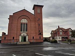
Saint Augustine of Canterbury (July 2021)
-
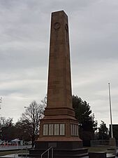
Ashburton war memorial (July 2021)


Ashburton Civic Centre and Library
The new Ashburton civic centre and library cost $56 million to build. It opened in 2023 and is located in the town centre, next to the clock tower.
Ashburton Clock Tower
The Ashburton clock tower was built in 1976. It was designed by Warren and Mahoney Architects. The clock inside was first used in 1904. The clock tower has won awards, including one for "Enduring Architecture" in 2004.
Ashburton Courthouse
The Ashburton courthouse is on Baring Square. Legal professionals in 2018 said it was very important to keep the courthouse open. If it closed, the closest courthouses would be in Christchurch or Timaru. The courthouse was updated in the 1990s, but it still needs more improvements and space.
Saint Andrews Presbyterian Church
Saint Andrews Presbyterian Church was designed by Robert and Edward England and built in 1906. It is listed as a Category 2 historic place by Heritage New Zealand.
Saint Augustine of Canterbury Catholic Church
Saint Augustine of Canterbury Catholic Church was built between 1930 and 1931. It is listed as a Category 1 historic place by Heritage New Zealand.
Ashburton War Memorial
The Ashburton war memorial is a tall, square monument. It was officially revealed on June 4, 1928.
Sports and Fun
Aquatic Centre
A new aquatic centre opened in Ashburton in May 2015. It has four indoor swimming pools inside a large building. There are also four indoor sports courts, two outdoor courts, and a gym. The Ashburton District Council runs this facility, which cost $30 million to build.
Clubs
The Ashburton Club and Mutual School of Arts (MSA) was started in 1885. It is a member of the NZ Chartered Clubs Association and is located in the town centre. The club currently has about 4,000 members.
Golf Courses
Ashburton has two golf courses. The Ashburton Golf Course is an 18-hole course that opened in 1895. The Tinwald Golf Club also has an 18-hole course in the suburb of Tinwald, built in 1967.
Horse Racing
The Ashburton Raceway is a place for horse racing. It has a 1500-metre (4,900 ft) long trotting track and an 1800-metre (5,900 ft) long galloping track. There is also a Harness Racing Museum at the racecourse. It is located off State Highway 1 at the northern end of Ashburton.
Mountain Bike Trails
Mountain Bike Ashburton built a mountain bike trail next to the Ashburton River. The loop track is 11.5 kilometres (7.1 miles) long.
Rugby
Ashburton is home to the Mid Canterbury Rugby Union. The Mid Canterbury team plays in the Heartland Championship.
Skiing
Mount Hutt is the closest ski field. It is located inland, just past Methven.
Cricket
Cricket has been played in Ashburton since at least 1877. The Ashburton County Cricket Association was formed in 1896. Its name changed to the Mid Canterbury Cricket Association in 1996. The Ashburton Domain is where Mid Canterbury plays its home games. The senior men's team won a national award, the Hawke Cup, in the 2003/04 season.
Speedway
The Ashburton Speedway has a race track for different types of cars, including stockcars and saloon cars. They also have a demolition derby once a year. The Ashburton Speedway is next to Ashburton Airport on Seafield Road.
Town Services
Ashburton Hospital

Ashburton Hospital is a 74-bed hospital located at 28 Elizabeth Street, Ashburton. It offers medical, surgical, radiology, and maternity care. About 5,000 patients stay overnight each year. It also sees 2,600 day patients and 15,000 outpatients. The hospital is run by the Canterbury District Health Board and had about 550 staff in 2021.
Rail Transport

The Main South Line railway line runs through the middle of Ashburton. The train station opened on August 24, 1874. The station's dining room closed in 1970 when the Southerner passenger service started. This service stopped on February 10, 2002.
However, the station is still used for freight. Some barley is sent by train to places like Marton. The station's container terminal is open on weekdays. The station building was taken down in 2013.
Tinwald was once a junction for the now-closed Mount Somers Branch railway line. The Tinwald station opened as Ashburton South on May 31, 1875. It was renamed Tinwald on March 18, 1878. It closed on October 11, 1981, except for private sidings. Part of the old line is still used by the Plains Vintage Railway.
In October 2021, the New Zealand government and the Ashburton District Council provided money for a new rail freight hub. This project will move the rail container terminal from the centre of Ashburton to Fairton. It is expected to be finished by the end of 2022 and cost about $14 million. This will help reduce traffic in the centre of Ashburton.
Road Transport
State Highway 1 goes through the centre of Ashburton. It is the main road connecting Christchurch and Dunedin. The highway crosses the Ashburton River using a bridge. This bridge is the only direct way for both local traffic and State Highway 1 traffic to cross the river.
SH1 Ashburton River Bridge
The bridge on State Highway 1 over the Ashburton River opened in 1931. It was the first 22-foot (6.7 m) wide bridge in New Zealand. On June 1, 2021, a big flood in the Ashburton River damaged the bridge's supports. The bridge deck sank a bit, causing it to close temporarily. At that time, there were no other ways for State Highway 1 traffic to cross the river, as all inland routes were also closed.
On June 3, 2021, the bridge reopened for heavy vehicles only during daylight hours. All restrictions were lifted on June 10. The Ashburton District Council has been trying to get money from Waka Kotahi (New Zealand Transport Agency) for a second bridge. This would help local traffic and make the road network more reliable. In 2021, the plan was to build the extra bridge in about 15 years.
Other Roads
State Highway 77 starts in Ashburton. It goes towards Methven, through the Rakaia Gorge, and then to Darfield.
Air Transport
The Ashburton Airport is near the town centre. It is a busy place for light aircraft, including general aviation and microlights. It is home to the Mid Canterbury Aero Club and Ashburton Aviation Pioneers.
In October 2021, there was a discussion about how the airport should be run in the future. As more planes use the airport, there could be more noise. This needs to be balanced with plans to develop the land around the airport.
Education in Ashburton

Ashburton has many schools: seven primary schools, one intermediate school, one secondary school, and one school that covers all years. All student numbers are as of February 2024. .
- Allenton School is a state primary school for Years 1–6. It has 351 students.
- Ashburton Borough School is a state primary school for Years 1–8. It has 262 students.
- Ashburton Christian School is a state-integrated Christian school for Years 1–13. It opened in 2009 as a private school and joined the state system in 2011. It has 271 students.
- Ashburton College is a state secondary school for Years 9–13. It opened in 1965 when Ashburton High School and Hakatere College merged. It has 1,293 students.
- Ashburton Intermediate School is a state intermediate school for Years 7–8. It opened in 1974. It has 466 students.
- Ashburton Netherby School is a state primary school for Years 1–6. It opened in 1959. It has 159 students.
- Fairton School is a state primary school for Years 1–6. It has 31 students.
- Hampstead School is a state primary school for Years 1–6. It has 281 students.
- St Joseph's School is a state-integrated Catholic primary school for Years 1–8. It has 221 students.
- Tinwald School is a state primary school for Years 1–6. It has Template:NZ school data students.
Media in Ashburton
Ashburton has its own daily newspaper, the Ashburton Guardian. There is also the Mid Canterbury Herald, a free weekly newspaper that comes out every Wednesday. The Courier is another free weekly newspaper. AshburtonOnline is a website focused on Mid Canterbury news.
Radio stations like Port FM (from Timaru), Newstalk ZB, and Classic Hits ZEFM are also available.
Famous People from Ashburton
Many notable people have come from Ashburton. These include:
- Jenny Shipley, a former Prime Minister of New Zealand.
- Tessa Birnie, an international concert pianist.
- Simon O'Neill, an international opera singer.
- Hayden Roulston, an Olympic silver medal cyclist.
- Simon Barnett and Robyn Malcolm, New Zealand television and radio personalities.
Rugby players Chris King and Fergie McCormick were born in Ashburton.
Hugo Friedlander was the Mayor of Ashburton three times (1879–1881, 1890–1892, and 1898–1901).
John Grigg was a local landowner and a Member of Parliament in the mid-1800s.
Dorothy Eden, a writer who wrote many novels, grew up in Ashburton.
The famous kite maker Peter Lynn is based in Ashburton.
|
