Ashburton River / Hakatere facts for kids
Quick facts for kids Ashburton River / Hakatere |
|
|---|---|

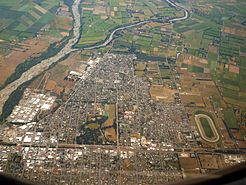
This view of Ashburton, New Zealand shows the confluence of south (on left) and north branches
|
|
| Country | New Zealand |
| Physical characteristics | |
| River mouth | Pacific Ocean 0 metres (0 ft) |
The Ashburton River / Hakatere is a river in the Canterbury region of New Zealand. It flows from the Southern Alps all the way to the Pacific Ocean. The river's official name was changed in 1998 to have two parts: Ashburton River and Hakatere. This was done as part of an agreement with the Ngāi Tahu Māori people.
The Ashburton River is also a very important place for birds. It has been named an Important Bird Area because it is home to breeding groups of the endangered black-billed gull. This means it's a special spot that helps protect these rare birds.
About the Ashburton River
The Ashburton River actually has two main parts, called branches. These two branches meet about 21 kilometres (13 mi) from the coast. This meeting point is just before the town of Ashburton.
Even after they meet, the branches stay close together. They run side-by-side for another 20 kilometres (12 mi). They are never more than 3 kilometres (1.9 mi) apart. They finally split up near a small place called Ashburton Forks.
The river flows southeast across the Canterbury Plains. It sits in a slightly lower area between two much bigger rivers, the Rakaia and Rangitata. These larger rivers have created higher areas of gravel and stones around them.
Both branches of the Ashburton River are crossed by the Rangitata Diversion Race. This is a special channel that carries water for irrigation. It helps farmers water their crops.
The river also divides the town of Ashburton from its southern suburb, Tinwald. Both the river and the town were named after Bingham Baring, 2nd Baron Ashburton. He was an important person who helped set up the Canterbury Association.
The North Branch of the River
| Ashburton River North Branch / Hakatere | |
|---|---|
| Physical characteristics | |
| Main source | Godley Peak 1,705 metres (5,594 ft) |
| Length | 98 kilometres (61 mi) |
| Basin features | |
| Tributaries |
|
The Ashburton River North Branch / Hakatere starts high up in the mountains. Its source is on the slopes of Godley Peak, which is 2,087 metres (6,847 ft) tall. The very top part of this river branch is sometimes called Petticoat Lane.
This branch first flows south, then southwest. It goes through narrow valleys with steep, rocky sides. There are almost no flat areas along the river here. The Black Hills Range and Pudding Hill Range are to its northeast. The Alford Range is to its southwest. The river leaves the hills near the Pudding Hill airfield.
The South Branch of the River
| Ashburton River South Branch / Hakatere | |
|---|---|
| Physical characteristics | |
| Main source | Ashburton Glacier 1,480 metres (4,860 ft) |
| Length | 113 kilometres (70 mi) (source – sea) |
| Basin features | |
| Tributaries |
|
The Ashburton River South Branch / Hakatere is the larger of the two branches. It begins as water flowing out of the Ashburton Glacier. This glacier is on Mount Arrowsmith, which is 2,781 metres (9,124 ft) high. The source of this branch is about 26 kilometres (16 mi) west of where the North branch starts.
At first, it flows southeast down a narrow valley. This valley is between the Big Hill Range and the Wild Man's Brother Range. About 10 kilometres (6.2 mi) from its start, the river turns south. Then it turns southeast again to cross the flat Hakatere Valley. Here, water from several small lakes, known as the Ashburton Lakes, joins the river.
The river then leaves the valley through the Ashburton Gorge. The Moorhouse Range is to the south, and the Clent Hills and Winterslow Range are to the north. Finally, it flows out onto the Canterbury Plains near Mount Somers. From there, it continues east towards Ashburton Forks.
 | Victor J. Glover |
 | Yvonne Cagle |
 | Jeanette Epps |
 | Bernard A. Harris Jr. |

