Arrowsmith Range facts for kids
Quick facts for kids Arrowsmith Range |
|
|---|---|
 |
|
| Highest point | |
| Peak | Mount Arrowsmith |
| Elevation | 2,781 m (9,124 ft) |
| Dimensions | |
| Length | 10 km (6.2 mi) |
| Geography | |
| Country | New Zealand |
| State/Province | Canterbury region |
| District | Ashburton District |
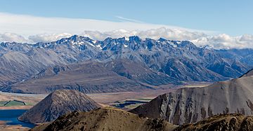
The Arrowsmith Range is a cool mountain range located on the South Island of New Zealand. It stretches from the southwest to the northeast, running alongside the much larger Southern Alps. The highest point in this range is called Mount Arrowsmith, which stands tall at 2,781 meters (about 9,124 feet).
People believe the range was named after John Arrowsmith. He was a British mapmaker who lived in the 1800s.
Tallest Mountains
The Arrowsmith Range has several important peaks. Here are some of the named mountains, listed from northwest to southeast:
| Name | Elevation (meters) |
|---|---|
| Prop Peak | 2408 |
| Jagged Peak | 2706 |
| Upham Peak | 2705 |
| Tower Peak | 2690 |
| The Twins | 2564 |
| Couloir Peak | 2642 |
| Mount Arrowsmith | 2781 |
| Ashburton Peak | 2359 |
| Hakatere Peak | 2298 |
| South Peak | 2343 |
Rivers and Waterways
Many rivers flow from the Arrowsmith Range.
- On the northwest side, the Lawrence River flows down. It eventually joins the Rangitata River.
- On the southeast side, you'll find the Ashburton River South Branch / Hakatere.
- The Cameron River also flows from this side, heading towards Lake Heron.
Glaciers and Snowfields
Even though the mountain peaks don't have ice or snow all year round, the Arrowsmith Range is home to several permanent snowfields and glaciers. These are large areas of ice and snow that stay frozen even in summer.
- Jagged Glacier
- Douglas Glacier
- Cameron Glacier
- South Cameron Glacier
- Ashburton Glacier
 | Shirley Ann Jackson |
 | Garett Morgan |
 | J. Ernest Wilkins Jr. |
 | Elijah McCoy |

