
Springfield, New Zealand facts for kids
Quick facts for kids
Springfield
Tawera (Māori)
|
|
|---|---|
|
Village
|
|

State Highway 73 passing through Springfield, with the Southern Alps beyond
|
|
| Country | New Zealand |
| Region | Canterbury |
| Territorial authority | Selwyn District |
| Ward | Malvern |
| Community | Malvern |
| Electorates |
|
| Area | |
| • Total | 1.89 km2 (0.73 sq mi) |
| Population
(June 2023)
|
|
| • Total | 370 |
| • Density | 196/km2 (507/sq mi) |
| Time zone | UTC+12 (NZST) |
| • Summer (DST) | UTC+13 (NZDT) |
| Postcode |
7681
|
| Area code(s) | 03 |
| Local iwi | Ngāi Tahu |
Springfield (also known as Māori: Tawera) is a small town in the Selwyn District of Canterbury. It is located on the South Island of New Zealand. Springfield sits at the base of the Southern Alps. It is the westernmost town on the Canterbury Plains.
Springfield is about 65 kilometers (40 miles) west of Christchurch. You can find it on State Highway 73, also called The Great Alpine Highway. The town is close to several ski fields. These include Porters Ski Area, Mount Cheeseman, and Temple Basin. Springfield has a long history with the Midland railway line.
Contents
History of Springfield

The town of Springfield began to grow around 1860. When gold was found on the West Coast, more people traveled through Springfield. The Springfield Hotel was first built in 1862. It grew to have 40 rooms. The hotel was an important stop for coaches traveling to the West Coast.
In the 1870s, water from the nearby Kowai River was used. This helped create one of the first water systems for farm animals in Canterbury.

The town has a beautiful Gothic Revival architecture church. It is named St Peter's Church. The famous architect Cyril Mountfort designed it. Springfield is also the birthplace of Rewi Alley. He was well-known for his work in China in the mid-1900s. There is a large memorial dedicated to him. It has a stone carving and panels about his life.
The Giant Doughnut
On July 15, 2007, a very special statue appeared in Springfield. It was a giant pink doughnut! This was put up to help promote The Simpsons Movie. Sadly, someone set it on fire and destroyed it in 2009. For a while, a pink-painted tire was used as a temporary replacement. A new, concrete doughnut statue was put in place on July 1, 2012.
Recent Events
In 2019, the Springfield Store and Café got a lot of attention. Some people called it the "rudest café" in New Zealand. Even the police visited to offer advice on customer service. The café is now under new ownership.
On May 29, 2021, most of Springfield had to be evacuated. This was because of heavy rain and flooding. Bishops Gully and the local water race overflowed. Many homes were flooded.
The Midland Railway Line

Springfield is an important stop on the TranzAlpine train journey. This train travels across the Southern Alps on the Midland Line. The town is also home to the Midland Rail Heritage Trust. This group works to preserve old trains. They have a base at the old railway depot. The Springfield Hotel was a popular stop for horse-drawn coaches. When trains became common, the train station's refreshment rooms were a favorite stop for travelers.
Since 2021, the Mainline Steam Heritage Trust has been moving its Christchurch depot to Springfield. They are building a new depot there.
Population Information
Springfield is considered a rural settlement by Statistics New Zealand. It covers about 1.89 square kilometers (0.73 square miles). As of 2018, Springfield had a population of 318 people. This was a big increase of 35.9% since 2013.
In 2018, there were 120 households in Springfield. There were more males (171) than females (147). About 24.5% of the people were under 15 years old. Most people (91.5%) identified as European/Pākehā. About 15.1% identified as Māori. Most people (63.2%) said they had no religion. About 29.2% were Christian.
Education
Springfield School is a primary school for students in years 1 to 6. It opened in 1872. As of 2023, the school had 63 students.
Where the Name Came From
There are a few ideas about how Springfield got its name. One idea is that J Bell named it in 1868 after an American Civil War battlefield. Another idea is that it was named like nearby towns, Darfield and Sheffield. The last idea is that the post office was named in 1870 after a spring in a field next to the local hotel.
Images for kids
-
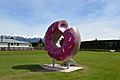
The "Springfield Doughnut"
-
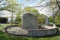
Rewi Alley memorial
-
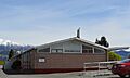
Springfield Railway Station


