
Aoraki / Mount Cook facts for kids
Quick facts for kids Aoraki / Mount Cook |
|
|---|---|

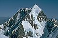
Aoraki / Mount Cook from Hooker Lake
|
|
| Highest point | |
| Elevation | 3,724 m (12,218 ft) |
| Prominence | 3,724 m (12,218 ft) Ranked 39th |
| Listing | Country high point Ultra |
| Geography | |

Aoraki / Mount Cook
Location in New Zealand
|
|
| Parent range | Southern Alps |
| Climbing | |
| First ascent | 1894 by Tom Fyfe, George Graham, Jack Clarke |
| Easiest route | glacier/snow/ice climb |
Aoraki / Mount Cook is the tallest mountain in New Zealand. It stands in the Southern Alps, a long mountain range that runs through the South Island. This amazing peak is a popular spot for tourists and a thrilling challenge for mountain climbers.
Since 2014, the mountain's height is 3,724 metres (12,218 feet). Before December 1991, it was 3,764 m (12,349 ft). This change happened because of a large rockslide and natural erosion. Aoraki / Mount Cook has three main tops: the Low Peak, Middle Peak, and High Peak. These peaks are found near the Tasman Glacier to the east and the Hooker Glacier to the southwest.
Contents
Discovering Aoraki / Mount Cook's Location
This famous mountain is located in the Aoraki/Mount Cook National Park. This park is in the Canterbury region of New Zealand. The park was created in 1953. It is part of a larger group of parks that form a UNESCO World Heritage Site.
The park is home to over 140 peaks that are taller than 2,000 metres (6,600 ft). It also has 72 named glaciers, which cover 40 percent of its 700 square kilometres (170,000 acres) area. Aoraki / Mount Cook sits at the northern end of the Kirikirikatata / Mount Cook Range. It forms a huge mountain block between the Hooker Valley and the Tasman Valley.
These two valleys offer the best and easiest views of Aoraki / Mount Cook. You can get a great view of the entire mountain from a lookout point at the end of the Hooker Valley Track. This spot is only 10 km from the peak.
The small town of Mount Cook Village is a tourist hub and a starting point for mountain adventures. It is about 7 km from the end of the Tasman Glacier. It is also 15 km south of Aoraki / Mount Cook's summit. On clear days, you can see Aoraki / Mount Cook from far away. It is visible from the West Coast, as far north as Greymouth, which is about 150 kilometers away.
You can also see it from most of State Highway 80 along Lake Pukaki. Another popular viewing spot is Lake Matheson on the West Coast. On calm days, the peaks of Aoraki / Mount Cook and Mt Tasman reflect perfectly in the lake.
Aoraki / Mount Cook's Unique Climate
Aoraki / Mount Cook gets a lot of rain and snow all year round. This happens because strong, moist westerly winds blow from the Tasman Sea. These winds bring rain clouds with them.
The weather around the mountain changes a lot. This is because of the way air moves across the Tasman Sea. The Aoraki / Mount Cook mountain range acts like a big wall. It blocks the moist air coming from the west. As this air rises over the mountains, it cools down and forms clouds.
Rain and snowfall are often heaviest around 1,200 m (3,900 ft) high. They can last for several days if the weather system moves slowly. The western side of Aoraki / Mount Cook can get over 10,000 mm (394 in) of rain each year. However, Mount Cook Village, which is only 15 km (9 mi) south, gets 4,484 mm (176.5 in) of rain or snow.
The weather on the eastern side of the mountain is usually better. But rain or snow can quickly spread there if the wind changes direction. This can cause temperatures to drop fast and make it hard to see. This makes climbing Aoraki / Mount Cook even more difficult.
At the base of the mountain, in the Hooker Valley (around 800 metres (2,600 feet) high), temperatures range from −13 °C (9 °F) to 32 °C (90 °F). Generally, the temperature drops about 1°C for every 200 meters you go higher. Above 1,000 m (3,300 ft), there are semi-permanent snow and ice fields in winter. Winter and spring usually have less stable weather than summer and autumn.
The Story of Aoraki / Mount Cook
Naming the Mountain

The name Aoraki comes from a person in the stories of the Ngāi Tahu iwi (tribe). An old name for the South Island is Te Waka o Aoraki, meaning "Aoraki's Canoe". Many people used to think Aoraki meant "Cloud Piercer". This idea came from combining ao (cloud) and raki (sky).
The Māori people knew Aoraki / Mount Cook after they arrived in New Zealand around the 14th century. The first Europeans who might have seen Aoraki / Mount Cook were part of Abel Tasman's crew. They saw a "large land uplifted high" in 1642.
The English name Mount Cook was given to the mountain in 1851 by Captain John Lort Stokes. He named it to honor Captain James Cook, who explored New Zealand in 1770. However, Captain Cook himself never actually saw the mountain.
In 1998, the mountain's name was officially changed to Aoraki / Mount Cook. This happened after an agreement between the Ngāi Tahu tribe and the New Zealand government. This change added its historic Māori name, Aoraki. It is the only place name where the Māori name comes before the English one. This shows how important Aoraki / Mount Cook is.
Climbing History

The first recorded attempt to climb Aoraki / Mount Cook was in 1882. It was made by William S. Green, Emil Boss, and Ulrich Kaufmann. They got very close to the top, perhaps within 50 meters.
The first successful climb happened on December 25, 1894. Three New Zealanders, Tom Fyfe, John Michael (Jack) Clarke, and George Graham, reached the summit. They were eager to be the first New Zealanders to climb it. They knew an American climber, Edward FitzGerald, was also trying.
The second climb was made by Swiss guide Matthias Zurbriggen in 1895. This was the first solo climb. After this, it took ten more years for someone to climb the mountain again. In 1905, Jack Clarke made his second ascent, becoming the first person to climb it twice.
The first woman to climb the mountain was Freda Du Faur from Australia in 1910. A Māori guide named George Bannister was the first Māori to reach the top in 1912. In 1913, Freda Du Faur and guides Peter and Alex Graham completed the first "grand traverse." This means they climbed all three peaks.
Sir Edmund Hillary climbed Aoraki / Mount Cook for the first time in 1948. Later that year, he made the first climb of the South Ridge. This ridge was renamed Hillary Ridge in 2011 to honor him.
Aoraki / Mount Cook is a very difficult mountain to climb. It has a lot of ice and glaciers. The conditions can change quickly due to weather, snow, and ice. Climbers face dangers like large cracks in the ice (crevasses), falling rocks and ice, and avalanches.
Since the early 1900s, about 80 people have died trying to climb Aoraki / Mount Cook. This makes it New Zealand's most dangerous peak. The climbing season is usually from November to February. Sadly, almost every season sees at least one death.
How Aoraki / Mount Cook Was Formed

The Southern Alps, where Aoraki / Mount Cook is, were formed by powerful forces. Two huge pieces of the Earth's crust, called the Pacific and Indo-Australian Plates, crashed into each other. This collision pushed the land upwards.
The mountains are still rising about 7 millimetres (0.28 in) each year. But strong forces like erosion also shape them. The mountain's harsh weather is due to its location in the path of the strong westerly winds known as the Roaring Forties. These winds blow around 45°S latitude. The Southern Alps are the first big obstacle these winds meet after crossing the Southern Ocean from South America.
The height of Aoraki / Mount Cook was first measured in the 1880s. In 1991, about 12–14 million cubic meters of rock and ice fell from the northern peak. This made the mountain about 10 metres (33 ft) shorter. Over the next twenty years, erosion of the ice cap made it even shorter. New measurements in 2013 showed its height is now 3,724 metres (12,218 ft).
Aoraki / Mount Cook sits in the middle of the Alpine Fault. This is a 650 km long active fault line in the Southern Alps. It is responsible for lifting Aoraki / Mount Cook. Scientists believe it moves every 100 to 300 years. Its last big movement was in 1717.
_from_Hooker_Glacier_Lake.jpg)
Forests and Glaciers Around the Mountain
The lowlands around Aoraki / Mount Cook, especially to the west, get a lot of rain. The average annual rainfall is around 5 to 10 metres (200 to 390 in). This heavy rainfall helps create temperate rainforests in these coastal areas. It also provides plenty of snow for the glaciers in the mountains.
These glaciers include the Tasman Glacier to the east and the smaller Hooker Glacier to the south. The plants in the valleys to the east, like the Tasman Valley, are not as green as those on the western slopes. Forests would normally grow up to about 1,300 m high here. But a lack of soil from rock falls and glaciers prevents this in many places.
Snow tussock and other alpine plants can grow as high as 1,900 m. Above the snowline, you will only find lichen among the rocks, snowfields, and ice that cover the highest parts of Aoraki / Mount Cook.
Māori Legends and Traditions

According to Māori legend, Aoraki was a young boy. He and his three brothers were the sons of Rakinui, the Sky Father. During a journey around Papatūānuku, the Earth Mother, their canoe got stuck on a reef and tipped over. Aoraki and his brothers climbed onto the high side of their canoe.
However, the south wind froze them and turned them into stone. Their canoe became Te Waka o Aoraki, which is the South Island. Their canoe's front parts became the Marlborough Sounds. Aoraki, being the tallest, became the highest peak. His brothers became the Kā Tiritiri o te Moana, which are the Southern Alps.
The Ngāi Tahu tribe, the main iwi of New Zealand's southern region, see Aoraki as their most sacred ancestor. Aoraki gives the tribe a sense of community and purpose. It remains the physical form of Aoraki and connects the worlds of spirits and nature.
Aoraki / Mount Cook Timeline
- 1642 – Abel Tasman and his crew may have seen Aoraki.
- 1770 – Captain Cook named the Southern Alps.
- 1851 – Captain Stokes named the mountain Mount Cook.
- 1894 – The first climb of Aoraki / Mount Cook happened on Christmas Day. It was by Jack Clarke, Tom Fyfe, and George Graham.
- 1910 – Freda du Faur became the first woman to climb Aoraki / Mount Cook.
- 1913 – Freda du Faur's climbing group made the first climbs of the Footstool and Mt Sefton.
- 1914 – The first deadly accident occurred when three men were caught in an avalanche on Linda Glacier.
- 1982 – Mark Inglis was trapped in a snow cave.
- 1991 – An avalanche of 10 million cubic meters of snow and rock caused the mountain to lose 10 meters from its top. Erosion over the next two decades reduced its height by another 30 meters to 3,724 meters. This was confirmed by new GPS data in 2013.
- 1998 – The Ngāi Tahu Claims Settlement Act officially recognized the original name. The mountain was renamed Aoraki / Mount Cook.
Images for kids
-
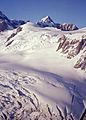
Aoraki / Mount Cook from above Franz Joseph Glacier
-
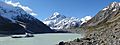
Aoraki / Mount Cook as seen from the end of the Hooker Valley Track, with the Hooker Glacier's moraine lake in the foreground.
-
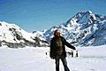
On Mt. Cook, New Zealand. 1977
-
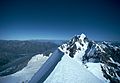
Aoraki peak from Mt Tasman summit NZ Mon 21 March 1983 wideangle
-
Aoraki peak from Mt Tasman summit NZ Mon 21 March 1983 closeup


See also
 In Spanish: Monte Cook para niños
