
Lake Pukaki facts for kids
Quick facts for kids Lake Pukaki |
|
|---|---|

Lake Pukaki
|
|

Lake Pukaki
Location in New Zealand
|
|
| Location | Mackenzie District, Canterbury region, South Island |
| Coordinates | 44°07′S 170°10′E / 44.117°S 170.167°E |
| Native name | Māori: Pūkaki |
| Primary inflows | Tasman River |
| Primary outflows | Pukaki River |
| Catchment area | 1,413 km2 (546 sq mi) |
| Basin countries | New Zealand |
| Surface area | 178.7 km2 (69.0 sq mi) |
| Average depth | 47 m (154 ft) |
| Max. depth | 70 m (230 ft) |
| Water volume | 4.66 km3 (3,780,000 acre⋅ft) |
| Surface elevation | 518.2 to 532 m (1,700 to 1,745 ft) |
| Frozen | never (winter air temperatures can reach as low as −20 °C (−4 °F) though) |
| Islands | Morgans Island |
| Settlements | Twizel |
Lake Pukaki (which is called Pūkaki in Māori) is the biggest of three large lakes in the South Island of New Zealand. These lakes are found along the northern edge of the Mackenzie Basin. The other two lakes are Tekapo and Ōhau.
All three lakes were made by glaciers. As the glaciers melted and moved back, they left behind piles of rock and dirt called moraines. These moraines blocked the valleys, creating the lakes. A fun mountain bike trail called the Alps2Ocean runs along part of Lake Pukaki.
Contents
About Lake Pukaki
The water in Lake Pukaki has a special bright blue color. This color comes from tiny rock particles called "glacial flour." These particles are made when glaciers grind rocks into a very fine powder.
Lake Pukaki covers an area of about 178.7 square kilometers. The lake's surface usually sits between 518.2 and 532 meters above sea level.
The lake gets its water from the Tasman River at its northern end. This river starts from the Tasman and Hooker Glaciers, which are near Aoraki / Mount Cook. On the west side of Lake Pukaki, you can see the Ben Ohau mountain range. On the eastern side, there are some farms between Lake Pukaki and Lake Tekapo.
You can get great views of the tall mountains in Aoraki / Mount Cook National Park from the southern shore of the lake. These mountains are about 70 kilometers away.
Himalayan Tahr Statue
Near the visitor center on the southern shore of Lake Pukaki, there is a life-sized bronze statue of a Himalayan tahr. A tahr is a type of wild goat. This statue stands on a large rock.
In 2020, this spot was where hunters protested against a plan to reduce the number of tahr in the area.
How the Lake Helps Make Electricity
Lake Pukaki is an important part of the Waitaki hydroelectric scheme. This scheme uses water to create electricity.
Originally, water flowed out of Lake Pukaki into the Pukaki River. But now, a dam holds back the water. Canals carry water from Lake Pukaki and Lake Ōhau to a power station called Ōhau A. From there, the water goes into Lake Ruataniwha.
Water from Lake Tekapo also flows into Lake Pukaki. It goes through a canal to another power station, Tekapo B, on Pukaki's eastern shore. The lake's water level has been raised twice to store more water. This happened in 1952 and again in 1976. When the lake was raised, an island called Five Pound Note Island was covered by water. This island used to be shown on New Zealand's five pound note.
Today, the lake's water level can be changed by 13.8 meters. This allows it to store a lot of energy, about 1,595 GWh. When combined with Lake Tekapo's storage, these two lakes hold more than half of New Zealand's hydroelectricity storage. This means they can store a lot of power for when it's needed.
Places Near the Lake
Long ago, the Ngāi Tahu people had a seasonal settlement on the southern shore of Lake Pukaki. It was called Punatahu and was used for gathering food.
The closest town to Lake Pukaki is Twizel, which is about 7 kilometers south of the lake. The town of Tekapo is 47 kilometers to the northeast. State Highway 8 goes along the southern end of the lake. State Highway 80 runs north along the western shore, leading to Mount Cook Village in the Aoraki / Mount Cook National Park.
Road Safety Near the Lake
State Highway 8 runs right next to Lake Pukaki. Many car crashes have happened here. Drivers often come around a bend, see the amazing view of the lake, and want to stop quickly. Sometimes they stop in unsafe places, which can cause accidents.
2020 Fire
In August 2020, a large scrub fire burned on the shores of Lake Pukaki. Both State Highway 8 and State Highway 80 had to be closed. Firefighters used 14 helicopters with water buckets, two planes, and 10 fire engines to fight the blaze.
The fire destroyed 3,500 hectares of land and took 12 days to put out. It cost $1 million to fight. Experts believe that the spread of wilding pines (trees growing where they shouldn't) and dry weather made the fire so destructive.
Pukaki Scientific Reserve
The Pukaki Scientific Reserve is a small protected area of 32 hectares. It is located on the western side of Lake Pukaki, near the road to Mount Cook. This reserve is home to a rare moth species called Izatha psychra, which is considered nationally endangered. The Lake Pukaki area also has a fly species called Anabarhynchus albipennis, but not much is known about it.
Climate Around Lake Pukaki
The weather around Lake Pukaki can be quite varied. Here is a summary of the average temperatures and rainfall:
| Climate data for Lake Pukaki, elevation 556 m (1,824 ft), (1971–2000) | |||||||||||||
|---|---|---|---|---|---|---|---|---|---|---|---|---|---|
| Month | Jan | Feb | Mar | Apr | May | Jun | Jul | Aug | Sep | Oct | Nov | Dec | Year |
| Mean daily maximum °C (°F) | 22.0 (71.6) |
22.4 (72.3) |
19.3 (66.7) |
15.3 (59.5) |
10.9 (51.6) |
6.5 (43.7) |
6.2 (43.2) |
8.5 (47.3) |
12.3 (54.1) |
15.0 (59.0) |
17.4 (63.3) |
19.7 (67.5) |
14.6 (58.3) |
| Daily mean °C (°F) | 15.9 (60.6) |
16.0 (60.8) |
13.6 (56.5) |
10.2 (50.4) |
6.4 (43.5) |
2.7 (36.9) |
2.3 (36.1) |
4.1 (39.4) |
7.3 (45.1) |
9.8 (49.6) |
11.9 (53.4) |
14.0 (57.2) |
9.5 (49.1) |
| Mean daily minimum °C (°F) | 9.7 (49.5) |
9.6 (49.3) |
7.9 (46.2) |
5.2 (41.4) |
1.9 (35.4) |
−1.1 (30.0) |
−1.7 (28.9) |
−0.3 (31.5) |
2.2 (36.0) |
4.5 (40.1) |
6.3 (43.3) |
8.3 (46.9) |
4.4 (39.9) |
| Average rainfall mm (inches) | 60.0 (2.36) |
41.0 (1.61) |
60.0 (2.36) |
58.0 (2.28) |
56.0 (2.20) |
45.0 (1.77) |
51.0 (2.01) |
43.0 (1.69) |
64.0 (2.52) |
65.0 (2.56) |
72.0 (2.83) |
58.0 (2.28) |
673 (26.47) |
| Source: CliFlo (rain 1951–1980) | |||||||||||||
Images for kids
-
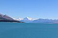
Lake Pukaki, looking towards Mount Cook, in summer
-
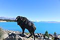
Statue of the Himalayan Tahr, introduced to New Zealand in 1904
-
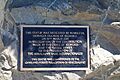
Plaque providing details about the introduction of the tahr
-
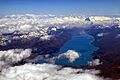
Aerial view of Lake Pukaki (2015)


